Report on Whakaari/White Island (New Zealand) — January 1999

Bulletin of the Global Volcanism Network, vol. 24, no. 1 (January 1999)
Managing Editor: Richard Wunderman.
Whakaari/White Island (New Zealand) Eruptive activity declines, alert level lowered to Level 1
Please cite this report as:
Global Volcanism Program, 1999. Report on Whakaari/White Island (New Zealand) (Wunderman, R., ed.). Bulletin of the Global Volcanism Network, 24:1. Smithsonian Institution. https://doi.org/10.5479/si.GVP.BGVN199901-241040
Whakaari/White Island
New Zealand
37.52°S, 177.18°E; summit elev. 294 m
All times are local (unless otherwise noted)
The eruptive activity on White Island (BGVN 23:10-23:12) continued but declined dramatically during the latter part of January. The alert level was lowered to Level One by the New Zealand IGNS.
Low volcanic-tremor levels rose overnight on 14-15 January to the highest levels recorded since the formation of the Metra Crater in early January (figure 39). Another tremor peak occurred during the evening of 15 January. On 16 January explosive activity in Metra Crater tossed blocks up to 400 m from the crater. Airborne observations during the explosive activity suggested multiple, differing eruptive events. Volcanic-tremor levels lessened on the 17th and later observations confirmed that no eruptions were occurring from Metra Crater. Overnight rains flooded the crater floor. A steam column rose 600 m above PeeJay Vent.
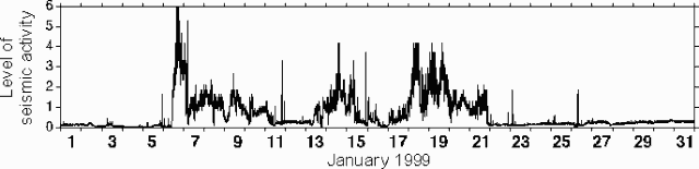 |
Figure 39. Seismic energy levels at White Island, January 1999. Courtesy IGNS. |
Activity declined dramatically after 22 January (figure 39). By 3 February activity at Metra Crater and PeeJay Vent was hydrothermal, dominated by volcanic gas-and-steam emissions and minor geysering. The alert level was lowered to Level One based on aerial observations and a review of the seismic activity. Weak to moderate gas-and-steam emissions issued from PeeJay Vent, including 300 to 400 tons/day of SO2 gas (2-3 times typical SO2 background levels). Metra Crater area was dominated by shallow pits containing small ponds, fumaroles, and geysers. On 2 February a gas plume extended >30 km from the volcano.
Geological Summary. The uninhabited Whakaari/White Island is the 2 x 2.4 km emergent summit of a 16 x 18 km submarine volcano in the Bay of Plenty about 50 km offshore of North Island. The island consists of two overlapping andesitic-to-dacitic stratovolcanoes. The SE side of the crater is open at sea level, with the recent activity centered about 1 km from the shore close to the rear crater wall. Volckner Rocks, sea stacks that are remnants of a lava dome, lie 5 km NW. Descriptions of volcanism since 1826 have included intermittent moderate phreatic, phreatomagmatic, and Strombolian eruptions; activity there also forms a prominent part of Maori legends. The formation of many new vents during the 19th and 20th centuries caused rapid changes in crater floor topography. Collapse of the crater wall in 1914 produced a debris avalanche that buried buildings and workers at a sulfur-mining project. Explosive activity in December 2019 took place while tourists were present, resulting in many fatalities. The official government name Whakaari/White Island is a combination of the full Maori name of Te Puia o Whakaari ("The Dramatic Volcano") and White Island (referencing the constant steam plume) given by Captain James Cook in 1769.
Information Contacts: Brad Scott, Wairakei Research Centre, Institute of Geological and Nuclear Sciences (IGNS) Limited, Private Bag 2000, Wairakei, New Zealand (URL: https://www.gns.cri.nz/).