Report on Kilauea (United States) — January 1999

Bulletin of the Global Volcanism Network, vol. 24, no. 1 (January 1999)
Managing Editor: Richard Wunderman.
Kilauea (United States) Pause in eruption leads to new surface flows
Please cite this report as:
Global Volcanism Program, 1999. Report on Kilauea (United States) (Wunderman, R., ed.). Bulletin of the Global Volcanism Network, 24:1. Smithsonian Institution. https://doi.org/10.5479/si.GVP.BGVN199901-332010
Kilauea
United States
19.421°N, 155.287°W; summit elev. 1222 m
All times are local (unless otherwise noted)
The eruption at Pu`u `O`o continued to deliver lava to the sea through the lava-tube system that developed on the coastal plain in August 1998 (BGVN 23:08). In early February a pause in the magma supply, number 22 in this eruption, produced changes throughout the system.
During November 1998-February 1999 there were very few surface flows on the volcano, although small pahoehoe flows continued on the active lava delta. This situation changed abruptly on 7 February following a brief pause in the supply of magma to Pu`u `O`o. When lava re-entered the tube system leading from Pu`u `O`o, lava spilled from several skylights and fed both `a`a and pahoehoe flows above and below the pali (figure 127). Some flows were still moving when photographed on 8 February.
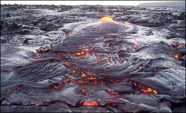 |
Figure 126. View of pahoehoe flow on the coastal plain of Kīlauea, taken 7 February 1999. Courtesy HVO; photo by H. McGiffert. |
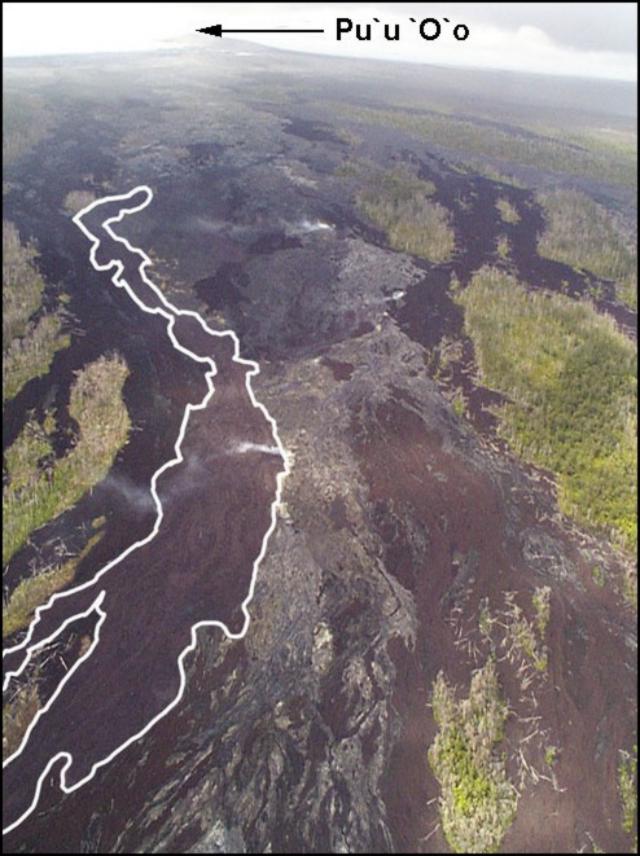 |
Figure 127. Surface flows from Kīlauea on Pulama pali as seen on 8 February 1999. The white line marks the edge of an `a`a flow that spilled down the pali (fault scarp). Courtesy HVO; photo by C. Seaman. |
Kīlauea's summit region showed significant tilt changes in early February (figure 128). The tilt record shows an episode of deflation beginning on 5 February that coincided with a cutoff of magma supply from Pu`u `O`o. Supply of lava to the tube system dwindled, and by early afternoon on 6 February the steam plume at the coast had ceased. Early on 7 February the summit underwent an abrupt 7-µrad inflation that lasted a little more than one hour and was followed by a summit deflation. About two hours later a substantial supply of magma reached the vent area. GOES satellite imagery showed a thermal spike between 0315 and 0330. By dawn, lava flows were visible from the end of the Chain of Craters road, a popular viewpoint for park visitors.
 |
Figure 128. Record showing tilt at Kīlauea along azimuth N50°W from a summit borehole tiltmeter at Uwekahuna vault. Tilt is recorded in µrad. Courtesy HVO. |
When the eruption at Pu`u `O`o resumed on 7 February, lava poured from several skylights to feed surface flows above and below Pulama pali. Spectacular explosive activity took place in mid-January at the lava delta, which was ~150 m wide on 8 February (figure 129). White fume clouds rose from areas where lava was entering the sea. The littoral cone near the SE edge of the delta was built by explosive activity in mid-January, caused when water temporarily gained access to the lava tube within the lava delta. Fumes in upper left were escaping from a lava-tube skylight.
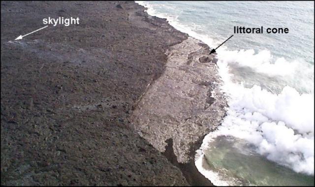 |
Figure 129. Aerial view of the lava delta (light toned surface) looking E on 8 February 1999. Courtesy HVO; photo by C. Seaman. |
Geological Summary. Kilauea overlaps the E flank of the massive Mauna Loa shield volcano in the island of Hawaii. Eruptions are prominent in Polynesian legends; written documentation since 1820 records frequent summit and flank lava flow eruptions interspersed with periods of long-term lava lake activity at Halemaumau crater in the summit caldera until 1924. The 3 x 5 km caldera was formed in several stages about 1,500 years ago and during the 18th century; eruptions have also originated from the lengthy East and Southwest rift zones, which extend to the ocean in both directions. About 90% of the surface of the basaltic shield volcano is formed of lava flows less than about 1,100 years old; 70% of the surface is younger than 600 years. The long-term eruption from the East rift zone between 1983 and 2018 produced lava flows covering more than 100 km2, destroyed hundreds of houses, and added new coastline.
Information Contacts: Hawaiian Volcano Observatory (HVO), U.S. Geological Survey, PO Box 51, Hawaii Volcanoes National Park, HI 96718, USA (URL: https://volcanoes.usgs.gov/observatories/hvo/); Hawaii Center for Volcanology, University of Hawaii, Department of Geology and Geophysics, 2525 Correa Road, Honolulu, HI 96822 USA (URL: http://www.soest.hawaii.edu/GG/hcv.html).