Report on Ol Doinyo Lengai (Tanzania) — February 1999

Bulletin of the Global Volcanism Network, vol. 24, no. 2 (February 1999)
Managing Editor: Richard Wunderman.
Ol Doinyo Lengai (Tanzania) Lava flows spilling over the crater rim in November 1998
Please cite this report as:
Global Volcanism Program, 1999. Report on Ol Doinyo Lengai (Tanzania) (Wunderman, R., ed.). Bulletin of the Global Volcanism Network, 24:2. Smithsonian Institution. https://doi.org/10.5479/si.GVP.BGVN199902-222120
Ol Doinyo Lengai
Tanzania
2.764°S, 35.914°E; summit elev. 2962 m
All times are local (unless otherwise noted)
The following report is based on photos taken between September and November 1998. Most of the photos were taken by local mountain guide Burra Ami Gadiye. Sketches and descriptions of the photos were provided by Celia Nyamweru of St. Lawrence University.
Lava from within the crater breached the rim, causing small lava flows down the outer crater wall; the breach on the NW probably occurred in late October, and the breach on the E began in early November. Small, narrow tongues of pahoehoe lava erupted continuously from vents around the upper slopes of cones T37S, T37N, and T40 (figure 55). Most of these flows moved E or NE, although a few moved W. The tops of T37S and T37N were built up into broad cones with jagged crowns. Some growth also occurred at T40. Little change was apparent on any of the other cones that were in existence in August (BGVN 23:10). In mid-November a new cone, which has been numbered T50, formed at the base of the SE wall.
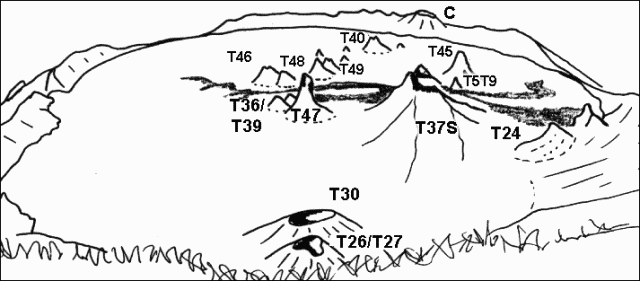 |
Figure 55. View of Ol Doinyo Lengai looking N from the summit on 29 September 1998. Traced by Celia Nyamweru from a photo by B.A. Gadiye. |
Activity during September and October. Narrow flows of pahoehoe lava emerged in late September from vents close to the summit of T37S and flowed E and W. The westward-flowing lava reached the center of the crater; the eastward-flowing lava reached the rim of T24 and the base of the crater wall. These flows were very dark in color suggesting they were still fluid or only very recently formed. The summit of T37S had a jagged profile (figure 56), replacing the broad dome seen in August.
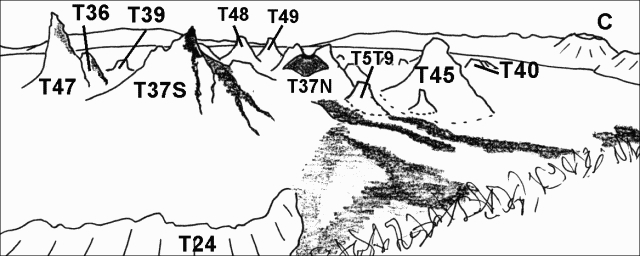 |
Figure 56. View of Ol Doinyo Lengai looking NW from SE crater rim as seen on 29 September 1998. Traced by C. Nyamweru from photographs by B. A. Gadiye. |
Small, narrow, very dark colored pahoehoe flows emerged in early October from vents close to the summits of T37S and T40 (figure 57). Behind T40 and to the right of T45, the T37 cluster showed some dark lava extending westwards from its summit past T47, the very tall narrow cone in front of the south wall. Cone T40 had fresh lava extending from the summit onto its lower slopes.
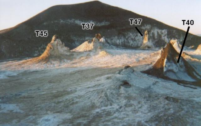 |
Figure 57. Photograph of Ol Doinyo Lengai taken on 3 October 1998 of the view S from the N crater rim. Courtesy B.A. Gadiye. |
In another photo on 7 October (figure 58), the top of T37S was dark brown, in striking contrast with the very pale brown lower slopes. Surrounding cones were pale brown. A large dark brown flow from a source between T45 and T37 extended around the eastern slope of T45. The flow showed no sign of whitening along the edges of the slabs, unlike the flow in front of it, and, therefore, might have been only a few hours old. The E crater wall was estimated to be 5 m high based on the appearance of a person in one photo. This was not an estimate of the lowest point on the crater wall.
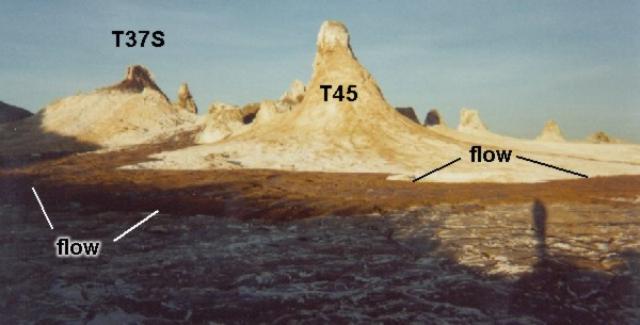 |
Figure 58. Photograph of Ol Doinyo Lengai taken on 7 October 1998 of the view SW from the E crater rim. Courtesy B.A. Gadiye. |
Activity during November. In early November fresh, black, shiny, pahoehoe lava flowed from a vent between T45 and T37S. Gadiye noted the source of the flow as the cone T5T9. Only the very top of T5T9 remained visible, since the remainder was covered by 20 m of lava. Another lava flow originated from a vent on the S slope of T40 and flowed around the E side of this cone. According to Gadiye the crater had filled and lava was pouring over the NW rim. A few weeks later he took two photographs, noting that the lava was spilling over the crater rim on the E and had burned the grass on the slope. The lava in one of these photos (taken just outside the rim) consisted of brown and gray smooth pahoehoe flows that did not seem to be more than 10 to 20 cm thick. Judging from the pale color, it had probably undergone weathering during the weeks since it flowed.
Aerial photographs taken late in November showed several narrow tongues of very dark lava over an older surface of white and pale brown lava. These dark flows originated from the slopes of T37S and from the cluster of cones around T37N1. A narrow white streak that overflowed the rim on the NW side was probably recent lava. A few days later fresh pahoehoe flows effused from T37S and T37N and flowed E toward the crater wall and the remains of the rim of T24 (figure 59). In this area was a new cone near the base of the S wall: a low circular feature, just out of view in figure 59, which Gadiye described as "a new cone near the SE rim that is boiling and giving out a lot of steam." This has been designated T50. Lava was seen to be overflowing the NW rim. T37S had a very jagged appearance and there also seemed to have been considerable growth at T37N1, between T37S and T45. Some fresh pahoehoe, very dark over the white older flows, was also visible farther west on the crater floor, near the T44/T48/T49 cone cluster.
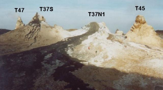 |
Figure 59. Photograph of Ol Doinyo Lengai taken on 24 November 1998 looking SW from the crater floor. Courtesy of B.A. Gadiye. |
Geological Summary. The symmetrical Ol Doinyo Lengai is the only volcano known to have erupted carbonatite tephras and lavas in historical time. The prominent stratovolcano, known to the Maasai as "The Mountain of God," rises abruptly above the broad plain south of Lake Natron in the Gregory Rift Valley. The cone-building stage ended about 15,000 years ago and was followed by periodic ejection of natrocarbonatitic and nephelinite tephra during the Holocene. Historical eruptions have consisted of smaller tephra ejections and emission of numerous natrocarbonatitic lava flows on the floor of the summit crater and occasionally down the upper flanks. The depth and morphology of the northern crater have changed dramatically during the course of historical eruptions, ranging from steep crater walls about 200 m deep in the mid-20th century to shallow platforms mostly filling the crater. Long-term lava effusion in the summit crater beginning in 1983 had by the turn of the century mostly filled the northern crater; by late 1998 lava had begun overflowing the crater rim.
Information Contacts: Celia Nyamweru, Department of Anthropology, St. Lawrence University, Canton, NY 13617 USA (URL: http://blogs.stlawu.edu/lengai/).