Report on Shishaldin (United States) — March 1999
Bulletin of the Global Volcanism Network, vol. 24, no. 3 (March 1999)
Managing Editor: Richard Wunderman.
Shishaldin (United States) Increased shallow seismicity precede April Strombolian eruptions
Please cite this report as:
Global Volcanism Program, 1999. Report on Shishaldin (United States) (Wunderman, R., ed.). Bulletin of the Global Volcanism Network, 24:3. Smithsonian Institution. https://doi.org/10.5479/si.GVP.BGVN199903-311360
Shishaldin
United States
54.756°N, 163.97°W; summit elev. 2857 m
All times are local (unless otherwise noted)
Low-level seismicity and a thermal anomaly visible in satellite imagery continued at Shishaldin during March, preceding Strombolian eruptions on 17 April. On many days no observations were obtained due to bad weather.
A new seismic net at Shishaldin recorded elevated seismicity beginning near the end of January. On 9 February a thermal anomaly appeared on satellite imagery and vigorous steam plumes were reported through the next week (BGVN 24:02). No ash was detected on the satellite imagery. Low-level tremor prompted the Alaska Volcano Observatory (AVO) to raise the Level of Concern Color Code to Yellow on 18 February. The tremor subsequently diminished, but seismicity remained above normal.
National Weather Service observers in Cold Bay, 90 km NE, reported that no steam plume was present during the first week of March, but that the upper summit was snow-free. Apparently, heating in the summit area caused the snow to melt. A shallow M 5.0 earthquake ~14 km SW of Shishaldin on 4 March was followed by hundreds of small aftershocks that persisted until late in the month.
Seismic activity, chiefly strong tremor, substantially increased above previous levels at 0800 on 7 April, causing AVO to raise the hazard status to Orange. Weather in the area was overcast with haze, preventing views of the summit area. The strong tremor declined by the afternoon and returned to previous levels. Tremor remained steady from 8 April without significant changes through 12 April, when the hazard status was decreased to Yellow. The thermal anomaly observed in satellite imagery persisted.
On 12 April a M 4.5 earthquake struck W of the volcano; aftershocks followed. Tremor increased markedly late on 13 April. This tremor episode lasted over one day and decreased somewhat for the next three days. AVO again raised the hazard status to Orange on 14 April.
AVO staff flying with Alaska State Troopers saw a minor Strombolian eruption at 1700 on 17 April. Incandescent blocks and spatter rose as high as 200 m above the vent, but at that time no lava had come over the crater rim. On the morning of 18 April, National Weather Service observers NW of the volcano both in Cold Bay and on a ship saw incandescent lava at the summit and snow melt running down the NW flank. A small steam plume with little or no ash developed as hot lava contacted snow at the summit. Tremor remained elevated.
On 19 April at 1145 a pilot saw a steam-and-ash plume that reached ~9 km altitude. In accord with this observation, tremor amplitudes increased dramatically after 1133 in the wake of a steady, two-day tremor increase. Observers interpreted these as signs of a significant eruption and raised the hazard status to Red. By early afternoon the eruption column reached at least 13.7 km altitude. The eruption lasted about 7 hours with one ash plume at higher elevations moving N and another, at lower elevations, S. Aviation warnings ("Graphic Volcanic Meteorological Impact Statements") for 0410-1610 on 19 April indicated two separate areas to avoid; one area spread ~300 km N over an elliptically shaped zone and the other, ~500 km S over a broadly spreading pattern that also included a lobe reaching ~375 km NW of Shishaldin (to Chignik). Late on the night of 19 April seismic tremor decreased substantially, but the Strombolian eruption continued at moderate levels.
On 20 April at about 0345, seismicity abruptly and significantly declined, indicating that explosive activity had subsided; still, satellite imagery after 0650 (1450 GMT) revealed a summit-crater thermal anomaly. Authorities decreased the hazard status to Orange. Seismic activity increased again about 1600. The increase in seismicity strengthened at about 2300 and on the morning of 21 April reached levels similar to those recorded in the hours before the explosive eruption on 19 April, and the hazard status returned to Red. Moderate Strombolian eruptions were thought to be occurring, though at the time satellite imagery failed to show a major ash cloud.
A moderate Strombolian eruption occurred through the night of 21 April. Seismicity became elevated and a very large thermal anomaly became visible on satellite imagery. Lava fountains shot tens of meters above the summit and satellite imagery indicated occasional steam and clouds of sparse ash extending for less than 50 km at altitudes under 5,000 m.
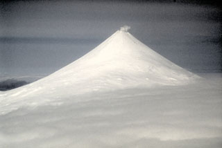
Geological Summary. The symmetrical glacier-covered Shishaldin in the Aleutian Islands is the westernmost of three large stratovolcanoes in the eastern half of Unimak Island. The Aleuts named the volcano Sisquk, meaning "mountain which points the way when I am lost." Constructed atop an older glacially dissected edifice, it is largely basaltic in composition. Remnants of an older edifice are exposed on the W and NE sides at 1,500-1,800 m elevation. There are over two dozen pyroclastic cones on its NW flank, which is covered by massive aa lava flows. Frequent explosive activity, primarily consisting of Strombolian ash eruptions from the small summit crater, but sometimes producing lava flows, has been recorded since the 18th century. A steam plume often rises from the summit crater.
Information Contacts: Alaska Volcano Observatory (AVO), a cooperative program of a) U.S. Geological Survey, 4200 University Drive, Anchorage, AK 99508-4667, USA (URL: http://www.avo.alaska.edu/), b) Geophysical Institute, University of Alaska, PO Box 757320, Fairbanks, AK 99775-7320, USA, and c) Alaska Division of Geological & Geophysical Surveys, 794 University Ave., Suite 200, Fairbanks, AK 99709, USA.