Report on Kikai (Japan) — May 1999
Bulletin of the Global Volcanism Network, vol. 24, no. 5 (May 1999)
Managing Editor: Richard Wunderman.
Kikai (Japan) 1997-99 summary; early 1999 eruption deposited 5 cm of ash at crater
Please cite this report as:
Global Volcanism Program, 1999. Report on Kikai (Japan) (Wunderman, R., ed.). Bulletin of the Global Volcanism Network, 24:5. Smithsonian Institution. https://doi.org/10.5479/si.GVP.BGVN199905-282060
Kikai
Japan
30.793°N, 130.305°E; summit elev. 704 m
All times are local (unless otherwise noted)
The following summarizes activity at Satsuma-Iwo-jima (also called Tokara-Iwo-jima), an island on the NW rim of Kikai Caldera. Information concerning events in 1997-98 was provided through communications from Yosihiro Sawada, forwarded by Dan Shackelford. More recent information is available at the Japanese Meteorological Agency (JMA) website.
JMA initiated seismic observation at Kikai in September 1997; from the beginning, several volcanic earthquakes were recorded each day. The number of earthquakes increased suddenly in April 1998 to 60-80/day with some days having more than 100 events. Earthquakes were at this high level during a field inspection on 4-5 May 1998. High numbers of earthquakes continued well into June, then gradually waned, before returning to levels seen in March (~10 events/day). Events decreased to <20/day by late June 1998, but increased again to 20-40/day during September, and to more than 60/day in late 1998.
During the inspection in May 1998, JMA staff found a newly deposited ash layer 5 cm thick around the crater, suggesting that an eruption had occurred in late-April or early-May. The Geological Survey of Japan (GSJ) analyzed the ash and concluded that it was composed of silicic and altered lava fragments of Iwo-dake lava (rhyolite). Residents of this volcanic island witnessed ash falls in August and October 1998. In early November GSJ scientists saw intermittent ash emissions from the crater and found ash deposits in the middle of the SE flank.
Volcanic earthquakes occurred 50-100 times/day during January and February 1999, and 90-130 times/day after February. Hypocenters of these earthquakes were located just below Iwo-dake. Island residents observed ash falling on 24 January [and 14 February 1999].
Geophysical activity is monitored by the Sakura-jima Volcano Observatory, Kyoto University, and JMA; geochemical data are maintained by GSJ.
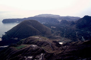
Geological Summary. Multiple eruption centers have exhibited recent activity at Kikai, a mostly submerged, 19-km-wide caldera near the northern end of the Ryukyu Islands south of Kyushu. It was the source of one of the world's largest Holocene eruptions about 6,300 years ago when rhyolitic pyroclastic flows traveled across the sea for a total distance of 100 km to southern Kyushu, and ashfall reached the northern Japanese island of Hokkaido. The eruption devastated southern and central Kyushu, which remained uninhabited for several centuries. Post-caldera eruptions formed Iodake (or Iwo-dake) lava dome and Inamuradake scoria cone, as well as submarine lava domes. Recorded eruptions have occurred at or near Satsuma-Iojima (also known as Tokara-Iojima), a small 3 x 6 km island forming part of the NW caldera rim. Showa-Iojima lava dome (also known as Iojima-Shinto), a small island 2 km E of Satsuma-Iojima, was formed during submarine eruptions in 1934 and 1935. Mild-to-moderate explosive eruptions have occurred during the past few decades from Iodake, a rhyolitic lava dome at the eastern end of Satsuma-Iojima.
Information Contacts: Yosihiro Sawada, Volcanological Division, Japan Meteorological Agency (JMA), 1-3-4 Ote-machi, Chiyoda-ku, Tokyo 100, Japan (URL: http://www.jma.go.jp/); Volcano Research Center, Earthquake Research Institute (ERI), University of Tokyo, Yayoi 1-1-1, Bunkyo-ku, Tokyo 113, Japan (URL: http://www.eri.u-tokyo.ac.jp/VRC/index_E.html); Dan Shackelford, 3124 E. Yorba Linda Blvd., Apt. H-33, Fullerton, CA 92831-2324 USA.