Report on Whakaari/White Island (New Zealand) — June 1999

Bulletin of the Global Volcanism Network, vol. 24, no. 6 (June 1999)
Managing Editor: Richard Wunderman.
Whakaari/White Island (New Zealand) Visit on 30 June reveals decreased activity
Please cite this report as:
Global Volcanism Program, 1999. Report on Whakaari/White Island (New Zealand) (Wunderman, R., ed.). Bulletin of the Global Volcanism Network, 24:6. Smithsonian Institution. https://doi.org/10.5479/si.GVP.BGVN199906-241040
Whakaari/White Island
New Zealand
37.52°S, 177.18°E; summit elev. 294 m
All times are local (unless otherwise noted)
White Island was visited on 30 June by IGNS scientists who reported that no significant eruptive activity had occurred since the explosive activity in April (BGVN 24:04). PeeJay vent was inactive and the only significant emissions of steam and gas came from the vent that formed in early May (at a spot E of PeeJay vent).
As the group arrived on 30 June a weak white steam-and-gas plume was rising 500-700 m above the volcano and moving ENE (figure 43). The plume was being fed by emissions from within the 1978/90 Crater Complex; the new vent E of PeeJay was the plume's strongest contributing source. Most of the gas and steam emitted (at high velocity) from this vent was from an inclined orifice near the S side of the vent. Other prominent sources included fumaroles near the lakeshore and in the valley wall W of the lake. PeeJay vent was inactive and had been filled by sediment that formed a flat floor about 3 m below the vent's rim. Activity had stopped in late May or early June.
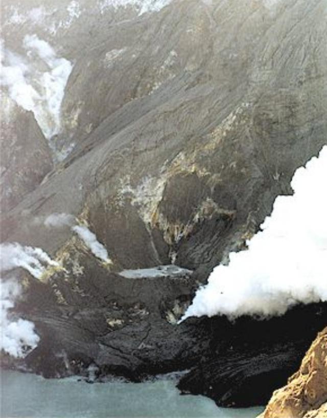 |
Figure 43. View of the 1978/90 Crater complex at White Island looking toward the NW on 30 June. Photograph courtesy of IGNS. |
The light-green colored lake within Metra Crater had enlarged and flooded into the NNE embayments of this crater. There was no evidence of further explosive activity from Metra Crater. No strong ebullition or convection was observed in the lake.
Geological Summary. The uninhabited Whakaari/White Island is the 2 x 2.4 km emergent summit of a 16 x 18 km submarine volcano in the Bay of Plenty about 50 km offshore of North Island. The island consists of two overlapping andesitic-to-dacitic stratovolcanoes. The SE side of the crater is open at sea level, with the recent activity centered about 1 km from the shore close to the rear crater wall. Volckner Rocks, sea stacks that are remnants of a lava dome, lie 5 km NW. Descriptions of volcanism since 1826 have included intermittent moderate phreatic, phreatomagmatic, and Strombolian eruptions; activity there also forms a prominent part of Maori legends. The formation of many new vents during the 19th and 20th centuries caused rapid changes in crater floor topography. Collapse of the crater wall in 1914 produced a debris avalanche that buried buildings and workers at a sulfur-mining project. Explosive activity in December 2019 took place while tourists were present, resulting in many fatalities. The official government name Whakaari/White Island is a combination of the full Maori name of Te Puia o Whakaari ("The Dramatic Volcano") and White Island (referencing the constant steam plume) given by Captain James Cook in 1769.
Information Contacts: Brad Scott, Wairakei Research Centre, Institute of Geological and Nuclear Sciences (IGNS) Limited, Private Bag 2000, Wairakei, New Zealand (URL: http://www.gns.cri.nz/).