Report on Mayon (Philippines) — June 1999

Bulletin of the Global Volcanism Network, vol. 24, no. 6 (June 1999)
Managing Editor: Richard Wunderman.
Mayon (Philippines) Explosion on 22 June sends a plume to ~10-12 km altitude
Please cite this report as:
Global Volcanism Program, 1999. Report on Mayon (Philippines) (Wunderman, R., ed.). Bulletin of the Global Volcanism Network, 24:6. Smithsonian Institution. https://doi.org/10.5479/si.GVP.BGVN199906-273030
Mayon
Philippines
13.257°N, 123.685°E; summit elev. 2462 m
All times are local (unless otherwise noted)
At 1658 on 22 June Mayon emitted an ash column that rose 7-10 km above the vent (figure 8). The emission was recorded by the seismic network of the Philippines Institute of Volcanology and Seismology (PHIVOLCS) as an explosion that lasted for 10 minutes. No volcanic earthquakes nor other visible signs of abnormal activity were observed before the explosion. During May, however, low-frequency volcanic earthquakes had been recorded intermittently, accompanied by faint crater glow.
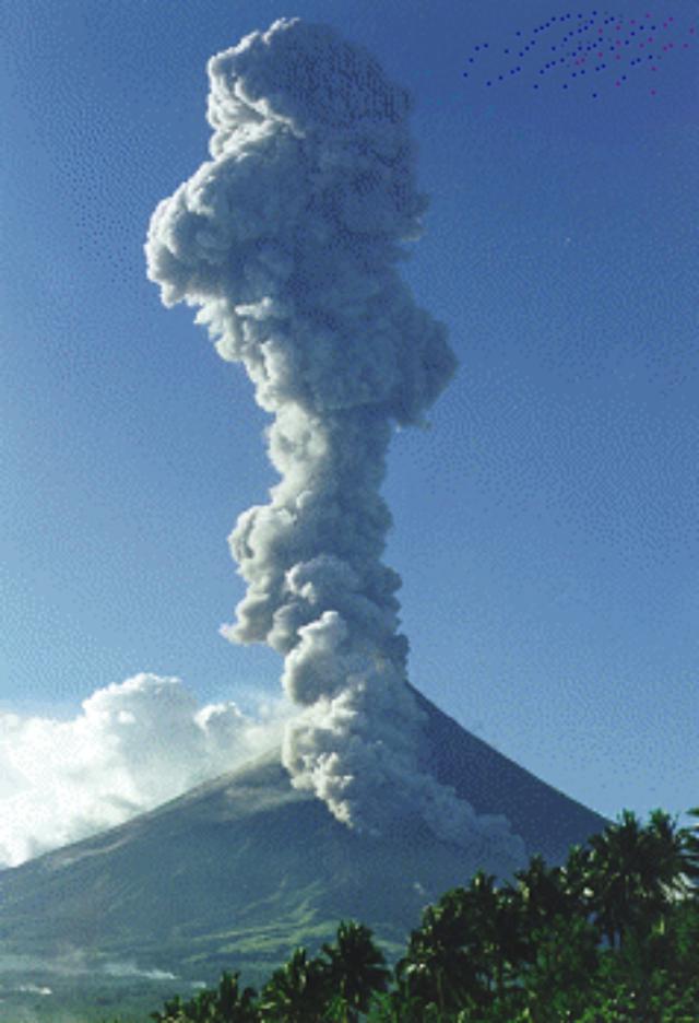 |
Figure 8. A column of steam and ash rising from Mayon's crater and a pyroclastic flow descending its SE flank during its sudden isolated explosion on 22 June. Photograph courtesy of PHILVOCS. |
The explosion represented an isolated event as activity immediately declined to typical incidents of weak steaming without measurable seismicity. Faint glow was seen the next day at the summit crater. An aerial survey noted a new explosion pit at the summit; the small diameter pit was later described as a deep hole lined with sulfur deposits (figure 9). The presence of sulfur suggested that lava had not yet ascended to the surface.
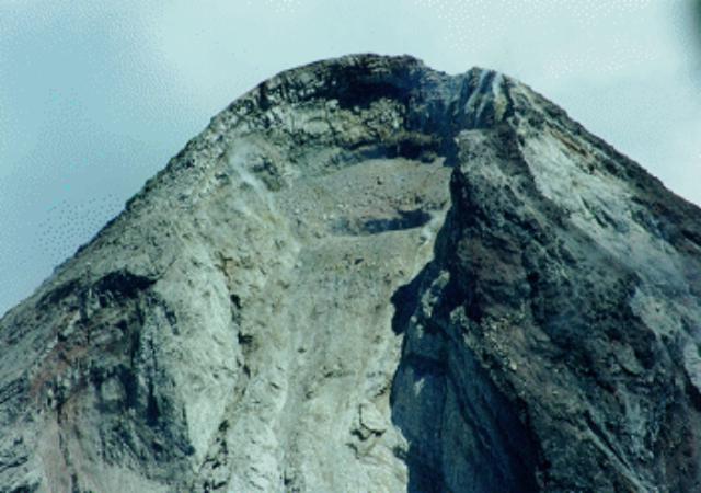 |
Figure 9. The crater of Mayon as it appeared after the 22 June explosion. A new, circular explosion pit developed on the crater floor; the shadow formed along the rim of this pit can be seen in this NW-looking photo shot through the breech. Courtesy of PHILVOCS. |
Beginning at 0700 on 25 June there was a slight increase in seismicity and SO2 emission. The COSPEC measured an SO2 flux of 4,800 tons/day, compared with 4,200 tons/day the previous day. SO2 fluxes normally average 500 tons/day. A short interval of high-frequency tremor was also recorded.
Tremor, light steaming, low-frequency volcanic earthquakes, and elevated SO2 fluxes continued for several days. Also, deformation surveys conducted with laser-ranging EDM equipment indicated sustained inflation on the SE slope.
PHIVOLCS maintained an alert status of "Level 1," advising the public not to venture within 6 km of the summit area (figure 10). In particular, residents were advised to avoid the Bonga pyroclastic fan, an area on the SE side of the volcano that contains a deep canyon and lies directly below the crater rim notch. This fan was the site of most of the fatalities in the 1993 eruption and is considered the area most vulnerable to future pyroclastic flows.
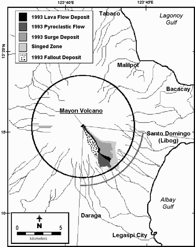 |
Figure 10. Details on Mayon and vicinity taken from a volcanic hazards map (PHILVOCS, 1999). The legend describes some effects of the 1993 eruption. The solid black circle represents the 6-km-radius safety zone currently in effect. An additional 1-km-wide precautionary zone lies to the SE of the volcano below the Bonga Pyroclastic Fan. Some local cities and river drainage are also shown. Courtesy of PHILVOCS. |
Reference. Philippine Institute of Volcanology and Seismology (PHIVOLCS), 1999, 1999 Mayon permanent danger & high susceptibility areas (map), URL: http://www.philonline.com/~seismo/Volcanoes/Mayon/MayonHazMaps.htm.
Geological Summary. Symmetrical Mayon, which rises above the Albay Gulf NW of Legazpi City, is the most active volcano of the Philippines. The steep upper slopes are capped by a small summit crater. Recorded eruptions since 1616 CE range from Strombolian to basaltic Plinian, with cyclical activity beginning with basaltic eruptions, followed by longer term andesitic lava flows. Eruptions occur predominately from the central conduit and have also produced lava flows that travel far down the flanks. Pyroclastic flows and mudflows have commonly swept down many of the approximately 40 ravines that radiate from the summit and have often damaged populated lowland areas. A violent eruption in 1814 killed more than 1,200 people and devastated several towns.
Information Contacts: Raymundo S. Punongbayan and Ronnie Torres, Philippine Institute of Volcanology and Seismology (PHIVOLCS), C.P. Garcia St. Diliman, Quezon City Philippines (URL: http://www.phivolcs.dost.gov.ph/).