Report on Cerro Negro (Nicaragua) — June 1999
Bulletin of the Global Volcanism Network, vol. 24, no. 6 (June 1999)
Managing Editor: Richard Wunderman.
Cerro Negro (Nicaragua) New map of changes to crater after 1992 and 1995 eruptions
Please cite this report as:
Global Volcanism Program, 1999. Report on Cerro Negro (Nicaragua) (Wunderman, R., ed.). Bulletin of the Global Volcanism Network, 24:6. Smithsonian Institution. https://doi.org/10.5479/si.GVP.BGVN199906-344070
Cerro Negro
Nicaragua
12.506°N, 86.702°W; summit elev. 728 m
All times are local (unless otherwise noted)
A team from Southwest Research Institute and Arizona State University visited Cerro Negro during 24 February-2 March. Their objectives were to map geomorphologic changes to the cone resulting from the 1995 eruption, estimate the respirable fraction of ash suspended above the 1992 and 1995 tephra blankets, and perform stratigraphic studies of tephra deposits.
A topographic map was prepared from 8,700 GPS measurements collected on and around the cinder cone (figures 12 and 13). Precision of individual measurements was within 1 cm and the survey had gross precision within 0.5 m.
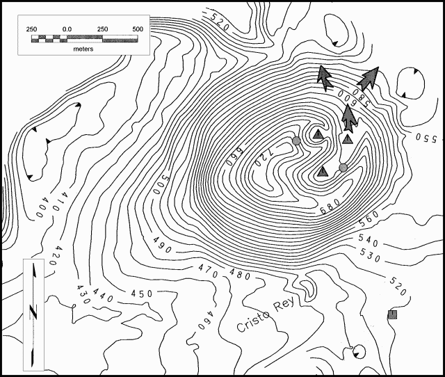 |
Figure 12. Topographic map of Cerro Negro volcano, prepared during 24 February-2 March. The contour interval is 10 m. Shaded triangles indicate the 1995 eruption vents, arrows show the direction of 1995 lava flows from the crater, shaded circles show positions of active fumarole areas, and the shaded square indicates the position of the INETER seismic station. Courtesy of Chuck Conner. |
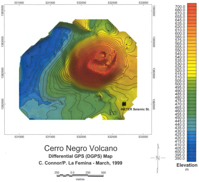 |
Figure 13. Color-shaded topographic map of Cerro Negro volcano, prepared during 24 February-2 March. The contour interval is 10 m. The black square indicates the position of the INETER seismic station. Courtesy of Chuck Conner. |
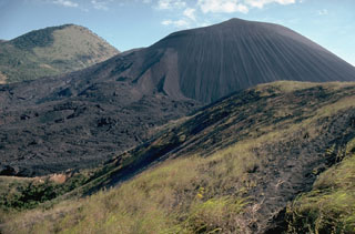
The cinder cone's morphology was changed significantly by the 1992 and 1995 eruptions. During the 1992 eruption the crater widened and now has an average diameter of 340 m. It was widest, 418 m, along its NE-SW axis because of a broad shoulder of tephra deposited on the SW side of the cone (during the 1992 and 1995 eruptions prevailing wind directions were from the NE). The diameter of the base of the cone was 945 m, measured between Cerro La Mula Ridge to the N of the cone and the Cristo Rey vent on the S. Data derived from air photos taken in 1986 revealed that this basal diameter had not changed substantially since then despite the 1992 and 1995 eruptions. The high point on Cerro Negro was measured at 728 m elevation, giving the cone a height of 258 m when measured relative to a topographic break in slope at the cone base, just west of Cristo Rey vent.
A small pyroclastic cone within the 1992 crater was created during the 1995 eruption. This new cone had a rim diameter of 124-130 m. Its crater depth was 94 m from the W rim (corresponding to the high point on Cerro Negro) and 44 m from the low point on the E side. Lava flows, emitted from at least two boccas on the 1992 crater floor during the 1995 activity, breached the N side of the 1992 cone. Because of this breach the low point on the 1992 crater rim was 9 m below the average rim elevation of 625 m.
No substantial degassing or other signs of volcanic unrest were observed during the seven days that the team was on-site and the area seemed unchanged since the cessation of the 1995 eruption. No thermal activity was observed on the 1995 lava flows, even on flow levees thicker than 3 m. These lava flows appeared to have cooled substantially as a result of the more than 3 m rainfall the region received during Hurricane Mitch in the Fall of 1998. Two fumarole areas were active; one fumarole area on the E of the crater has likely persisted since before the 1992 eruption. These fumaroles were easily accessible due to the breaching of the N crater rim by the 1992 lava flows. A new fumarole area had been established high on the W rim of the 1995 pyroclastic cone, just below the high point on Cerro Negro. Sulfur, anhydrite, and halite were deposited in these areas. Low-temperature fumaroles (<100°C) were found along arcuate fractures that paralleled the 1992 cone rim. These fractures were most prominent on the S side of the cone where they were faulted with 0.1-1.0 m displacements, down toward the outer cone flank and up toward the crater, because of slumping on the outer flank. They were radial on the SW of the cone, where the outer cone slope was buttressed by 1992 and 1995 tephra accumulations. Similar fractures and small faults also occurred on the NW rim and around the 1995 pyroclastic cone. Low-temperature fumaroles were also found on the southernmost 1995 bocca and a small mound within the 1992 crater. Fumaroles and steaming ground persisted on Cerro La Mula Ridge.
Crater fumarole measurements. The temperature of crater fumaroles has been measured during visits by Alain Creusot since 1995 (BGVN 21:11, 21:12, and 23:03). From November 1995, when a significant eruption took place, to October 1996, fumarole temperatures were as high as 700°C. On 27 November 1996, a visit to the crater found that fumarole temperatures had generally decreased by 80-100°C and the maximum temperature was only 630°C. On 23 December 1996 the maximum fumarole temperature was only 606°C. An additional decrease of fumarole temperatures was noted on a 5 September 1997 visit; the maximum temperature measured was only 405°C (previously unreported). The highest temperature found on 14 February 1998 was 340°C.
References. Hill and others, 1998, Eruptions of Cerro Negro volcano, Nicaragua, and risk assessment for future eruptions, Geological Society of America, Bulletin, v. 110, p. 1231-1241.
Connor and others, 1996, Soil 222Rn pulse during the initial phase of the June-August 1995 eruption of Cerro Negro, Nicaragua, Journal of Volcanology and Geothermal Research, vol. 73, p.119-127.
Geological Summary. Nicaragua's youngest volcano, Cerro Negro, was created following an eruption that began in April 1850 about 2 km NW of the summit of Las Pilas volcano. It is the largest, southernmost, and most recent of a group of four youthful cinder cones constructed along a NNW-SSE-trending line in the central Marrabios Range. Strombolian-to-subplinian eruptions at intervals of a few years to several decades have constructed a roughly 250-m-high basaltic cone and an associated lava field constrained by topography to extend primarily NE and SW. Cone and crater morphology have varied significantly during its short eruptive history. Although it lies in a relatively unpopulated area, occasional heavy ashfalls have damaged crops and buildings.
Information Contacts: Chuck Connor, Peter La Femina, Brittain Hill, James Weldy, Center for Nuclear Waste Regulatory Analyses, Southwest Research Institute, 6220 Culebra Rd, San Antonio, TX, 78238-5166; Kurt Roggensack and Berry Cameron, Department of Geological Sciences, Arizona State University, Tempe, AZ; Alain Creusot, Instituto Nicaraguense de Energía, Managua, Nicaragua.