Report on Tungurahua (Ecuador) — November 1999

Bulletin of the Global Volcanism Network, vol. 24, no. 11 (November 1999)
Managing Editor: Richard Wunderman.
Tungurahua (Ecuador) Explosions continue; 1998-99 summary; ~25,000 people displaced for months
Please cite this report as:
Global Volcanism Program, 1999. Report on Tungurahua (Ecuador) (Wunderman, R., ed.). Bulletin of the Global Volcanism Network, 24:11. Smithsonian Institution. https://doi.org/10.5479/si.GVP.BGVN199911-352080
Tungurahua
Ecuador
1.467°S, 78.442°W; summit elev. 5023 m
All times are local (unless otherwise noted)
Frequent explosive eruptions continued at Tungurahua volcano through 30 November (figure 1 and table 2). Ash plumes rose to maximum heights of about 5 km above the summit. Daily explosions increased during the month, reaching a peak during 16-25 November before decreasing slightly (figures 2 and 3). On 19 November 0.5 mm of ash fell on Baños, 9 km NNE of the summit at an elevation of ~1,850 m. Two millimeters of ash fell on the town of Runtún farther up slope at ~2,350 m elevation and ~6.2 km NE of the summit.
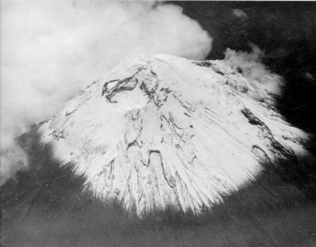 |
Figure 1. An aerial oblique photograph of Tungurahua taken from the W during July 1974 shows the morphology of the snow-and-ice-covered summit crater prior to the current eruption. Courtesy of the Geophysical Institute. |
Table 2. Explosions and other activity at Tungurahua as described in daily reports, 31 October to 30 November 1999. Courtesy of the Geophysical Institute.
| Date | Number of Explosions | Observations |
| 31 Oct 1999 | 28 | Night observations of incandescent emissions falling on upper cone; an ash-bearing plume rose ~3 km about the summit. |
| 01 Nov 1999 | 21 | A 3 km plume deposited ash in Banos and 31 km SW of the summit in Riobamba. |
| 02 Nov 1999 | 22 | On two occasions, plumes rose to ~5 km above the summit; windows vibrated 12 km from the summit. |
| 03 Nov 1999 | 34 | Ash deposited 32 km NW of the summit in Ambato. |
| 04 Nov 1999 | 25 | Plumes up to 5-km tall were produced; vibrations and explosions continued; sulfur smell noted in the city of Banos; harmonic tremor recorded. |
| 05 Nov 1999 | 22 | Weather clouds covered the plumes. |
| 06 Nov 1999 | 32 | Dense, 3-5 km plumes were seen during the day. |
| 07 Nov 1999 | 27 | ~1.5 km plume dispersed to the N and S. |
| 08 Nov 1999 | 24 | Blocky pyroclastic flows with over 1 km runout distances. |
| 09 Nov 1999 | 19 | -- |
| 10 Nov 1999 | 27 | -- |
| 11 Nov 1999 | 29 | Ash columns to 1.5 km height. |
| 12 Nov 1999 | 28 | Ash column to ~10 km altitude (~5 km above the summit); blowing E. |
| 13 Nov 1999 | 15 | Plume to about 2 km produced containing minor ash and directed NW. |
| 14 Nov 1999 | 25 | Plume heights unstated but plume visible to NNW on satellite imagery. |
| 15 Nov 1999 | 37 | Morning eruptions discharged ash plumes that moved NNW. |
| 16 Nov 1999 | 43 | Airborne observations of an ash-rich plume ascending to 5-km above the summit and blowing NW; a satellite image also showed the plume at ~5 km altitude. |
| 17 Nov 1999 | 55 | A consistent 1-km-tall ash plume directed to the N. |
| 18 Nov 1999 | 83 | Loud booming noises; continuous series of ~5-km-tall, W-directed plumes. |
| 19 Nov 1999 | 64 | Morning eruptions, plume blowing SW; in the past few days there was ~0.5 mm of ash deposited in Banos and up to ~2 mm deposited in Runtun (see text). |
| 20 Nov 1999 | 47 | A strong rain produced mud flows; some crossed roads; reports stated one mudflow was 20 m wide (see text). |
| 21 Nov 1999 | 67 | -- |
| 22 Nov 1999 | 55 | A large quantity of blocks and incandescent material found on sides of volcano; 1-2 km plume produced and inclined to the NE. |
| 23 Nov 1999 | 96 | Emissions rose to 1 km over the summit. |
| 24 Nov 1999 | 102 | Up to ~2-km-tall plumes of vapor and ash directed to the E. |
| 25 Nov 1999 | 97 | Taller plumes reached 3-4 km height; ~3,300 tons/day SO2 emitted in an interval with a constant 1-km-tall plume. |
| 26 Nov 1999 | 35 | An explosion of vapor and ash rose 1 km above the summit of the volcano; a ~5-km-tall plume formed; 1 cm ash accumulated in one sector during the past weeks. |
| 27 Nov 1999 | 16 | 4 km ash-bearing column rose after the explosion. |
| 28 Nov 1999 | 13 | A 500-m-tall vapor column was seen. |
| 29 Nov 1999 | 46 | An explosion produced a 4-km-tall column; loud noises heard. |
| 30 Nov 1999 | 62 | Observers noted strong thunder sounds; vibrations felt ~10 km away. |
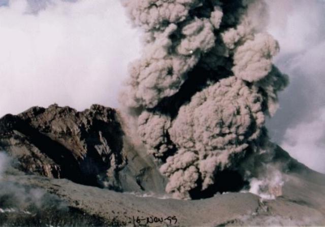 |
Figure 2. A dark ash plume rises from Tungurahua's formerly snow-covered summit crater on 16 November 1999. Courtesy of the Geophysical Institute. |
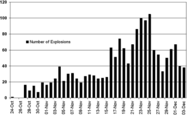 |
Figure 3. A histogram indicating the number of daily explosions at Tungurahua during 24 October to 30 December 1999. Explosions were most frequent during 22-25 November. Courtesy of the Geophysical Institute. |
A pronounced peak in monthly earthquakes during August-September diminished rapidly in October and still farther in November (figure 4). The greatest number of monthly earthquakes were volcano-tectonic, in a pattern that became prominent in September 1998 and prevailed until October 1999. The ratio of multiphase to long-period earthquakes showed significant variability. In some months (eg., February, March, May, June, and September 1999) the multiphase events dominated. August 1999 showed the extreme reversal of this pattern with 436 long-period and 58 multiphase events. The last two months shown on figure 4, October and November, portrayed a similar though less pronounced reversal in their relative abundance of the multiphase events. These months also displayed a comparative scarcity of volcano-tectonic events.
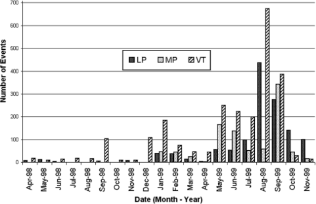 |
Figure 4. A histogram for Tungurahua showing three types of monthly earthquakes occurring between April 1998 and November 1999. For any given month, from left to right the earthquakes shown are long-period (LP), hybrid or multiphase (MP), and volcano-tectonic (VT). All three types plot on the same scale, shown on the left side of the histogram. Courtesy of the Geophysical Institute. |
SO2 flux during the crisis (figure 5) showed wide variability. Comparatively high fluxes were measured prior to the eruption. On the eruptions first day, 5 October, measured SO2-flux values reached 9,000-10,000 metric tons/day (t/d) (BGVN 24:09). The highest fluxes, seen during mid-September through early November, also showed rough, though inexact correlations with the seismic and explosion patterns.
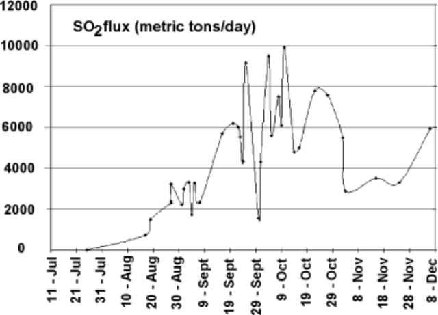 |
Figure 5. SO2 flux measured at Tungurahua during 11 July-8 December 1999. Although error bars were not provided they are typically on the order of plus or minus 10-20%. Courtesy of the Geophysical Institute. |
Two mud flows were reported on 20 November. They occurred after a strong rain that washed large tree trunks and rocks into a main highway in Baños. One of these mudflows was 20 m wide; another earlier in the day blocked part of a different highway in Baños.
1998-99 activity divided into five stages. In January 2000 the Geophysical Institute issued a summary report that divided 1998-99 activity into five stages. The first stage, December-May 1998, included swarms of small predominantly volcano-tectonic earthquakes. Tremor also continued, presumably associated with a phreatic source; this kind of tremor has been detected since 1993 and is thus here referred to as persistent or long-lived tremor.
The second stage, May 1998-15 July 1999, was an interval when seismic swarms (including volcano-tectonic (VT), long period (LP), and hybrid or multiphase (MP) earthquakes) became more energetic. Small explosion signals began to register from greater-than-shallow depths. The preponderance of VT earthquakes was interpreted as a result of stress beneath the edifice due to intruding magma. Stable-frequency tremor at that time underwent a slight increase in amplitude.
In the third stage, which began after 15 July 1999, tremor included higher frequency signals. Geophysicists noted a series of many small earthquakes of all kinds that continued until mid-December. At the end of July came the first reports of strong sulfurous odors in the vicinity of the crater. In the meantime, SO2 fluxes rose from essentially zero to 3,200 t/d (figure 5).
During 24-28 July and 8-10 September LP earthquake swarms struck with significant energy. Seismicity continued to rise considerably during August and early September. An alert was declared on 8 September 1999.
The fourth stage began 14 September 1999 when low-frequency tremor appeared, presumably associated with degassing and ascending magma. The persistent tremor increased in amplitude. On 14 September a column of vapor 2 km tall was observed. On 15 September the alert status rose to yellow. Later and until 25 October tremor reached extraordinarily high amplitudes and contained three dominant frequencies: 1, 1.7, and 2-2.5 Hz.
The first explosive activity was reported on 5 October (BGVN 24:09), when blocks and ash were ejected at 0721, 0738, and 0743 hours. This emission was associated with a comparatively big explosive seismic signal with a reduced displacement of 25 cm2 and high SO2 fluxes. The next day an ash plume rose to 2 km above the summit; small airfall ash deposits were found in Quero, Bilbao (where the thickness was given as 2 mm), and probably in Ambato. Subsequent Geophysical Institute reports described small ash-bearing or "dark" plumes to 0.5-5 km above the summit.
On 13 October observers first noted incandescence. SO2 fluxes rose to over 10,000 t/d (figure 5). Deformation at one of the tilt stations on the SW underwent significant changes. Activity increased on 16 October when an ash plume reached ~5 km above the summit and blew W. During the previous night's darkness observers saw incandescent ash and blocks deposited on the upper flanks of the volcano. On 16 October the alert status was raised from yellow to orange, prompting evacuations of Baños and settlements along Tungurahua's W and SW flanks (see below).
During the fifth stage, which began after 25 October, the persistent tremor remained near the levels seen in the third stage. Low-frequency tremor also continued. SO2 fluxes dropped to 3,500-4,000 tons/day in mid-November. Magmatic explosions became common in this stage. At night observers saw pyroclasts descending 1-2 km below the summit. Ash-charged plumes rose 3-5 km above the summit. During 1999 the Geophysical Institute tallied 2,030 explosions and emissions, 2,542 VT earthquakes, 4,086 LP earthquakes, and 1,038 MP earthquakes.
Geography and hazards. Baños sits in a narrow valley on the N margin of the volcano 75 miles S of Quito and 9 km NE of Tungurahua's summit. Baños lies along the Pastaza river (draining the N flanks) below the Chambo river (draining the W flanks over the NW to SW sector). This geography leaves Baños open to "high hazard for directed blasts and fallback pyroclastic flows" as well as lahars (Hall and others, 1999). Within this hazard zone, ~4.5 km downstream, sits the Agoyan dam, an important source of hydroelectric power.
Tungurahua is very dangerous because it has 3 km of vertical relief, 30°slopes, a record of previous sector collapses and a comparatively high propensity for future collapses, a pre-evacuation at-risk population of ~25,000 people, a major hydroelectric dam on its NNE margin, and a record of relatively violent, sudden andesitic eruptions with pyroclastic flows (Hall and others, 1999). The same authors noted that the volume of magma emitted by Tungurahua during the last 2,300 years has been ~3.45 km3. This gives it a magma flux rate similar to that at Merapi during the last century and 2- to 3-fold larger than the estimated rates seen in the Central Andes during the Late Cenozoic.
Evacuations. The newspaper El Universo reported that on 16 October when Tungurahua's volcanic activity increased and its hazard status first rose to orange, evacuations followed at cities closest to the volcano, including Baños. On 21 October the United Nations (UN) reported that the evacuations relocated "22,000 persons from some 60 locations." El Universo noted that at one point nearing the end of the evacuation one hundred buses were used.
As of late October some of the residents had moved to Ambato, 32 km NW of the volcano. Official sources indicated that 1,200-1,500 evacuees went to temporary shelters in the provinces of Tungurahua, Chimborazo, and Pastaza. Besides Ambato, individual cities that took refugees included Puyo (45 km E of the summit) and Shell (41 km E). About 100 families found shelter in a religious foundation and 200 families on a farm belonging to the Polytechnic Institute of Chimborazo. The UN further reported that ~600 military police and personnel have been deployed to the affected region to protect abandoned property. Access into this area was to be strictly prohibited.
The UN reported that 4,000 livestock, 100,000 fowl, and the animals from the zoological garden in Baños had also been evacuated. According to the Associated Press, a government census found that 40,000 chickens died from respiratory infections during early October.
According to the Associated Press, Baños had been evacuated for two months when on 13 December a caravan of residents briefly returned. During this brief visit, one resident entered his home and found it intact, although most parts of the house lay covered in ash. Residents faced an uncertain future because they did not know exactly when they would be able to return. The governor of Tungurahua province, Ignacio Vargas said, "This won't be permanent. We will have to wait until the eruption ends so that everyone can return to his normal activities."
Because of economic problems associated with leaving their homes and livelihoods, Baños area residents have been bypassing the military to plant crops and tend their farms. According to early January ABC News reports there have even been skirmishes between residents and the military. The eruptions are occurring in the context of tension and conflict between the military and some Unions and other groups as the country's economy has worsened.
Reference.: Hall, M., Robin, C., Beate, B., Mothes, P., Monzier, M., 1999. Tungurahua Volcano, Ecuador: structure, eruptive history and hazards: Journal of Volcanology and Geothermal Research, v. 91, p. 1-21.
Geological Summary. Tungurahua, a steep-sided andesitic-dacitic stratovolcano that towers more than 3 km above its northern base, is one of Ecuador's most active volcanoes. Three major edifices have been sequentially constructed since the mid-Pleistocene over a basement of metamorphic rocks. Tungurahua II was built within the past 14,000 years following the collapse of the initial edifice. Tungurahua II collapsed about 3,000 years ago and produced a large debris-avalanche deposit to the west. The modern glacier-capped stratovolcano (Tungurahua III) was constructed within the landslide scarp. Historical eruptions have all originated from the summit crater, accompanied by strong explosions and sometimes by pyroclastic flows and lava flows that reached populated areas at the volcano's base. Prior to a long-term eruption beginning in 1999 that caused the temporary evacuation of the city of Baños at the foot of the volcano, the last major eruption had occurred from 1916 to 1918, although minor activity continued until 1925.
Information Contacts: Instituto Geofísico, Escuela Politécnica Nacional, Apartado 17-01-2759, Quito, Ecuador; Embassy of Ecuador, 2535 15th Street NW, Washington, DC 20009 USA (URL: http//www.ecuador.org/); United Nations Office for the Coordination of Humanitarian Affairs (OCHA), Palais des Nations, 1211 Geneva 10, Switzerland; El Universo, Quito, Ecuador (URL: http://www.eluniverso.com/); Associated Press, International Headquarters, 50 Rockefeller Plaza, New York, NY 10020 USA (URL: http://www.ap.org/); ABC News (URL: http://abcnews.go.com/).