Report on Rotorua (New Zealand) — October 2000
Bulletin of the Global Volcanism Network, vol. 25, no. 10 (October 2000)
Managing Editor: Richard Wunderman.
Rotorua (New Zealand) Additional details about the 18 September 2000 hydrothermal eruption
Please cite this report as:
Global Volcanism Program, 2000. Report on Rotorua (New Zealand) (Wunderman, R., ed.). Bulletin of the Global Volcanism Network, 25:10. Smithsonian Institution. https://doi.org/10.5479/si.GVP.BGVN200010-241816
Rotorua
New Zealand
38.08°S, 176.27°E; summit elev. 757 m
All times are local (unless otherwise noted)
This report provides more details on the previously reported, small-scale hydrothermal eruption on private property that occurred on 18 September 2000 (BGVN 25:08). That report contained an ambiguous statement. Brad Scott refined the statement that several small-scale hydrothermal eruptions "were reported" in the past year; the passage should have read that such eruptions "have occurred" in the past year. Scott noted further: "The increase in activity is related to the closure of many geothermal wells within Rotorua City as part of a management scheme designed to preserve the surface geothermal features." For further details see Scott and Cody (2000).
Surface features resulting from the eruption can be seen in figure 1. The twisted metal pipes are related to an old bath house, which used to stand near the clothes line mentioned in BGVN 25:08. The pipes fed water to the bath house and were excavated by the eruption. The original clothes line was completely removed off site before the eruption occurred.
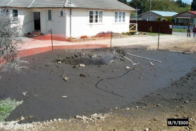 |
Figure 1. A photo showing the disrupted area caused by a small hydrothermal eruption at Rotorua on 18 September 2000, as seen later that day. The eruption left this collapse vent and fine mud. The eruption also brought up and deformed some previously buried metal pipes. Courtesy of Brad Scott, GNS. |
Ron Keam contributed the following hazards assessment to the GOSA electronic list (geysers@wwc.edu). "If the area of an average house at Tarewa Road were one tenth of the average section area, the probability that the focus of one of these revived activities would occur beneath a dwelling is roughly 10%. So far, with three or four incidents having occurred, I think that the houses themselves were spared from direct participation in the initial events. With the average craterlet enlarging itself somewhat, there must be a comparable probability that an average sized house would in due course find itself partially overhanging the craterlet. So, in all, there appears to be something like a 20% probability that an outbreak on an average property would make a dwelling there uninhabitable.
A search of an index to the Geyser Observation and Study Association (GOSA) newsletter revealed two articles referring to Rotorua breakouts due to hydrothermal activity (see References below). Ashley Cody also discussed Rotorua hydrothermal features (Cody, 1998). Note that the elevation of Rotorua city is about 320 m; the 575 m stated in the header above refers to the highest point on one of the young domes within the caldera. All of New Zealand's recognized Holocene volcanoes lie on North Island or just to its N. Rotorua sits in the northern part of the Taupo volcanic zone between Lake Taupo and the Bay of Plenty. The Okataina lava domes lie ~20 km E of Rotorua.
In related hydrothermal activity on Rotorua, the Pohutu Geyser at the active geyser area Whakarewarewa has been in continuous eruption for 251 days, a new and continuing record for New Zealand.
References. Cody, A., 1998, GOSA Transactions, The Rotorua Geothermal Field, New Zealand: Geysers in New Zealand, v. VI, p. 34-49.
Geyser Observation and Study Association (GOSA) newsletter, 1998, "The Geyser Gazer Sput." (v. 12, no. 3, p. 23; v. 12, no. 4, p. 11) (December 1998).
Monteith, David, 2000, Index of "The Geyser Gazer Sput," December 1987 - December 1998 (http://www.geocities.com/Yosemite/1407/Sputind.htm).
Scott, B.J., and Cody, A.D., 2000, Response of the Rotorua geothermal system to exploitation and varying management regimes: Geothermics, v. 29, p. 573-592.
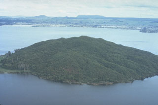
Geological Summary. The 22-km-wide Rotorua caldera is the NW-most caldera of the Taupo volcanic zone. It is the only single-event caldera in the Taupo Volcanic Zone and was formed about 220,000 years ago following eruption of the more than 340 km3 rhyolitic Mamaku Ignimbrite. Although caldera collapse occurred in a single event, the process was complex and involved multiple collapse blocks. The major city of Rotorua lies at the south end of the lake that fills much of the caldera. Post-collapse eruptive activity, which ceased during the Pleistocene, was restricted to lava dome extrusion without major explosive activity. The youngest activity consisted of the eruption of three lava domes less than 25,000 years ago. The major thermal areas of Takeke, Tikitere, Lake Rotokawa, and Rotorua-Whakarewarewa are located within the caldera or outside its rim, and the city of Rotorua lies within and adjacent to active geothermal fields.
Information Contacts: Brad Scott, Wairakei Research Center, Institute of Geological and Nuclear Sciences (IGNS), Private Bag 2000, Wairakei, New Zealand (URL: http://www.gns.cri.nz/); Ron Keam, The Physics Department, The University of Auckland, Private Bag 92-019, Auckland, New Zealand.