Report on Popocatepetl (Mexico) — December 2000

Bulletin of the Global Volcanism Network, vol. 25, no. 12 (December 2000)
Managing Editor: Richard Wunderman.
Popocatepetl (Mexico) December set records in tremor, dome extrusion rates, SO2 flux, and tilt
Please cite this report as:
Global Volcanism Program, 2000. Report on Popocatepetl (Mexico) (Wunderman, R., ed.). Bulletin of the Global Volcanism Network, 25:12. Smithsonian Institution. https://doi.org/10.5479/si.GVP.BGVN200012-341090
Popocatepetl
Mexico
19.023°N, 98.622°W; summit elev. 5393 m
All times are local (unless otherwise noted)
Around the end of the year 2000 and in January 2001 Popocatépetl extruded dome lavas at record-setting rates and amassed the largest active dome ever recorded on the volcano. The seismic energy released in one 25-hour interval in mid-December was greater than the accumulated energy for any entire year for which measurements are available. The highest plume of the interval rose to ~8 km above the summit crater.
During late 2000 into January 2001, but particularly in December, tremor reached the biggest amplitudes yet recorded during this multi-year crisis; it was felt by people 12-14 km distant, and one tremor episode prevailed for ~10 hours. Another episode saturated instruments to the point of damage and drove tiltmeters in dramatic oscillations.
Although impressive plumes had been seen before in this crisis, for the first time hot ash and gases began escaping the summit crater regularly, accompanied by pyroclastic flows and mudflows. The longest pyroclastic flow reached a runout distance of ~8 km. Preliminary photo analysis made during episodes of harmonic tremor in mid-December led to lava extrusion-rate estimates that were more than an order of magnitude higher than those typically seen at stratovolcanoes. During mid-December, sulfur dioxide (SO2) fluxes reached ten to twenty times larger than the volcano's typical ~5,000 tons/day.
Although later Bulletin reports will provide more details, what follows here are critical highlights for assessing the behavior through 29 January. The report was provided by Servando de la Cruz-Reyna, Carlos Valdés-Gonzalez, Roberto Quaas-Weppen, and affiliated CENAPRED scientists noted below.
Relative quiet followed by unrest. The previous episode of dome growth took place in February 2000, resulting in the smallest of all domes grown since 1996 (see BGVN 25:01). After a period of relative quiescence, unrest followed at Popocatépetl in early September 2000 (BGVN 25:10). This marked the beginning of a new episode.
September unrest was marked by two seismic observations. First, harmonic tremor appeared in the peak of the exhalation signals. Second, tectono-volcanic earthquakes below the crater were followed by long-duration explosive eruptions that generated higher-altitude plumes. GOES satellite imagery depicted strong thermal anomalies in the crater. Still, only comparatively minor dome growth was detected in mid-September, and this same pattern continued during early November. A variable, somewhat reduced level of activity continued into early December.
Escalation in December 2000. As discussed below, RSAM values climbed precipitously during a 7-day interval in mid-December. Prior to that, on 2 December an ash emission of moderate-to-large size lasted about 90 minutes. On 6 December, nine low-magnitude earthquakes (M ~1.7-2.4) occurred followed by a similar swarm on 8-9 December. These earthquakes, in turn, were followed by a period of low-frequency harmonic tremor that lasted about 5 minutes. Although brief, this tremor had the largest amplitude recorded since this eruptive period began in 1994.
Particularly during December, tiltmeters, for the first time since their installation, registered all of the large tremor signals (figure 30). Tilt oscillation amplitudes were typically in the range of 100 µrad, reaching peak-to-peak values near 200 µrad. Seismicity during 11-18 December was extremely high (figures 31 and 32).
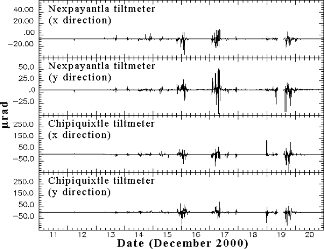 |
Figure 30. Tilt at Popocatépetl recorded by various stations for 11-20 December 2000. The large tilt displacements occurred in conjunction with high-amplitude tremor. The x and y directions are neither radial nor strictly tangential in orientation. The two axes lie at right angles on a horizontal plane such that a line 45 degrees away and bisecting both these axes trends through the center of the volcano. Courtesy of CENAPRED. |
Eruptive activity increased on 12 December 2000 with frequent ash-bearing emissions (up to 200 per day), some of them reaching about 5-6 km above the volcano's summit. During the following night observers saw incandescence and small amounts of hot debris. Similar activity and longer-duration eruptions during 13-15 December produced light ashfalls on towns around the volcano.
Early on 15 December more episodes of high-amplitude, low-frequency harmonic tremor were detected, lasting a few minutes. At 1404, the low-frequency harmonic tremor grew to a continuous signal, with amplitudes peaking on all the monitoring stations, including the most distant one. These signals were strong enough to be felt by residents 12-14 km away, and to be detected at stations of the Mexican Seismological Network as far as 150 km from the volcano. This tremor episode remained at constant intensity for about 10 hours, and may have stemmed from very high rates of lava extrusion.
Starting early on 16 December activity underwent a dramatic drop that was reversed 16 hours later by a return of low-frequency harmonic tremor of increasing amplitude. This tremor again saturated all monitoring stations; it lasted about 9.5 hours. The amplitudes of the signals were so high that pen drivers and several styli of the paper-drum recorders were damaged. A still-larger tremor episode took place on 18-19 December.
Figures 31 and 32 illustrate the seismic traces and cumulative RSAM data. RSAM peaked during an interval of slightly over 7 days in mid-December, when low-frequency tremor prevailed for ~25 hours and the seismic energy released exceeded that of the rest of the year 2000. Actually, the peak surpassed that accumulated during any previous entire year for which records exist (including 1997, see figure 32).
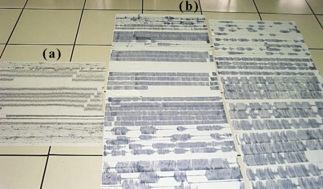 |
Figure 31. Paper-drum records from Popocatépetl photographed while laid out on a flat surface. The records depict the record-setting seismic signals at Canario station (PPPN) on 30 June 1997 (labeled "a") and on 18-19 December 2000 (labeled "b"). Some of the records in the latter set (b, central to upper left) were re-scaled when the maximum pen displacement was shifted from 8 cm to 4 cm in order to stop damaging pens and motors during ongoing saturating oscillations. It is clear that the amplitude and duration of the 18-19 December 2000 events greatly exceeded those from 30 June 1997. Prior to mid-December, the 30 June 1997 events represented the largest amplitude tremor seen since 1994. Courtesy of CENAPRED. |
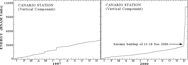 |
Figure 32. Real-time seismic amplitude measurement (RSAM) plots for two Popocatépetl stations for the years 1997-8 and 2000, illustrating the extremely high seismic energy release seen in a time interval just over 7 days long (11-18 December 2000). This interval includes the acute increase seen on 18 December 2000. This ~7-day interval's energy release was eightfold larger than the total annual release in 1997. Courtesy of CENAPRED. |
The episodes of quiescence and high-amplitude, low-frequency harmonic tremors occurred in such a pattern that they could be described as a load-and-discharge model, as suggested by the time-predictable model of Shimazaki and Nagata (1980). Using this paradigm, workers forecast the onset of the 18 December eruption and tremor episode.
Aerial photos taken on 16 December showed significant dome growth inside the crater (figure 33) and allowed correlation of the episodes of high amplitude, low-frequency harmonic tremor with periods of lava extrusion at very high rates. Analysis of the photos indicated that the dome grew at an average rate of ~180-200 m3/s during the episodes of intense harmonic tremor. This rate, which was not sustained, was about two orders of magnitude higher than any other previously observed.
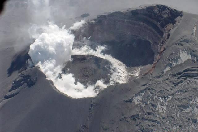 |
Figure 33. A photograph taken looking into the crater at Popocatépetl, as viewed from the N on 16 December 2000. The substantial glacier on the N side lies covered by ash. Courtesy of CENAPRED. |
At Popocatépetl, correlation spectrometer (COSPEC) measurements of SO2 flux have had yearly averages on the order of 5,000 metric tons/day (t/d). In contrast, during 13-19 December the estimates were in excess of 50,000 t/d. On 19 December the reported value was near 100,000 t/d.
Civil authorities were made aware of the high magnitude of the monitoring signals, the very high rate of lava production, and the growth of the largest dome yet observed. This motivated them to constitute, on 15-16 December, an emergency board. They declared a further increase in the alert level and defined a security radius of 13 km. This radius was suggested to include at least some of the most vulnerable towns, like Santiago Xalitzintla (centered ~15 km NE of the crater) and San Pedro Benito Juarez (with a few residences 10 km SE of the crater, but the main town at 12 km from it). Santiago Xalitzintla sits downstream of the E side of the largest glacier along one of the main N-flank drainages. San Pedro Benito Juarez lies on a fracture zone on the SE flank, an area where many of the largest tectono-volcanic earthquakes were located. Additionally, increased deformation was also detected using the geodetic network located on that fault. San Pedro Benito Juarez is an isolated town closest to a notch in the SE crater rim. This notch is believed to have formed by collapse on 24 February 1664 during an eruption similar to the current one.
Preventive evacuation of Santiago Xalitzintla, San Pedro Benito Juarez, and other towns began on late 15 December and early 16 December. The decisions regarding which other towns should be evacuated were made by authorities at the state and municipal level. This caused some towns, well outside the security radius of 13 km, to also be evacuated by decision of their mayors. About 41,000 people left the area. Around half left the region by their own will and means. The other half used resources provided by local civil protection authorities. Of these, ~14,000 accepted transportation to shelters where they remained for about 10 days. Others moved to stay with relatives or friends.
The total volume of fresh lava accumulated within the crater of Popocatépetl was estimated to be between 15 and 19 million cubic meters on 18 December, exceeding the combined volume of all the previous domes (figures 33 and 35). The estimated vertical growth rate of the dome was such that another 20 or 30 hours of tremor associated with the above-mentioned lava production rate could potentially have enabled the dome to begin escaping the confines of the crater. The rate slowed, however, and the dome's upper surface remained well within the crater (figures 33 and 35).
As anticipated by the applying the above-mentioned model, after a three-day period of relative quiescence, on the afternoon of 18 December, a new eruption began. The relatively low-explosivity, yet long-lasting eruption of 18-19 December (figure 34) ejected large amounts of hot debris on the flanks of the volcano in three episodes of incandescent fountaining. Ejected hot debris is believed to have ultimately flowed a maximum distance of 5-6 km from the crater. Some images of these eruptions were distributed by some news media, which had installed cameras around the volcano and broadcast images in real time. After 19 December activity decreased noticeably. The next expected period of unrest, suggested by the time-predictable model to ensue near 23 December (figure 35), did not occur, likely indicating that the rate of magma supply had changed. What was believed to be the first dome-destruction explosion of this episode occurred on 24 December, ejecting incandescent debris to a distance of 3.5 km from the volcano, and producing an ash plume estimated to reach 5 km above the crater. When the nature and size of this event was understood, authorities reduced the security radius to 12 km. No towns lie within that radius, and accordingly many people returned to their homes.
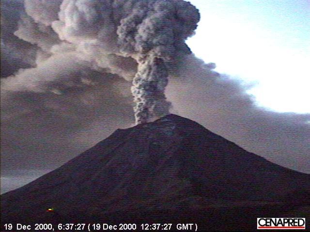 |
Figure 34. An ash-bearing eruption column rises from Popocatépetl on 19 December 2000, viewed from the N. This kind of activity was common during the energetic mid-December time interval and stimulated international attention (e.g. the media and websites of Reuters, Stromboli Online, and others). Courtesy of CENAPRED. |
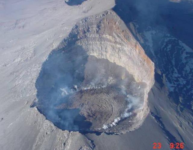 |
Figure 35. Aerial photograph taken looking into the crater at Popocatépetl, as seen from the NE on 23 December. Courtesy of CENAPRED. |
Later explosive events failed to excavate substantial portions of the new dome. The current estimate as of 16 January 2001 was that ~10-20% of the new dome volume has been blown out by explosions recorded after 18 December 2000. In many of the previous dome growth-and-destruction episodes since 1996, most of the dome mass has been removed by small to moderate (VEI <= 2) explosions; a similar scenario may play out in the near future.
After several weeks of relative calm, significant activity resumed at Popocatépetl on 22 January. At 1458 a M 2.8 volcano-tectonic earthquake occurred on the E flank. This event was possibly a precursor to a large ash emission that started at 1615, and initially produced an ash plume several kilometers in height. Eight minutes later observers saw a more explosive phase throwing incandescent fragments around the crater. After several more minutes, pyroclastic flows were generated and moved 4-6 km down several ravines on the N flank. Ash emission from the crater was continuous and punctuated by intermittent explosions. By 1640, the ash plume towered more than 8 km above the summit crater. At 1800 fluctuating harmonic tremor, similar to that of December, was registered. At times the signals again reached saturation amplitudes; the tremor could have been associated with magma intrusion into the base of the crater, an idea also suggested to explain previous tremor events. Harmonic tremor lasted for ~30 minutes. Ashfall was documented in Santiago Xalitzintla, Atlixico, and parts of Puebla and Tetela del Volcán. At 2200 it was possible to see ejected incandescent fragments that fell up to 1 km from the crater. On 29 January (figure 36), pyroclastic flows caused some glacial melting. The pyroclastic flows initially reached up to 8 km from their source, halting in the drainage upstream of Santiago Xalitzintla. They triggered some glacial melting and in early February their deposits were remobilized and came to rest about 15 km from the crater, about 2 km upstream of Santiago Xalitzintla. As of 29 January Popocatépetl remained at a Stage 3 Yellow alert.
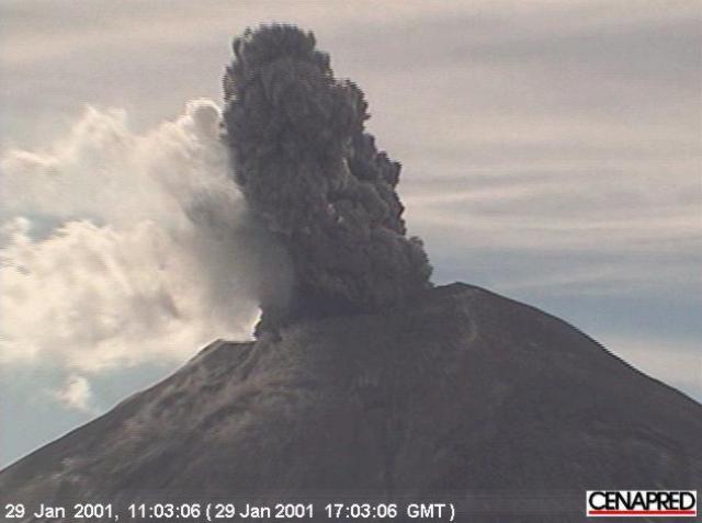 |
Figure 36. Popocatépetl on 29 January photographed looking S. The image captured the forceful ejection of an ash-laden cloud. Courtesy of CENAPRED. |
Reference. Shimazaki and Nagata,1980, Time-predictable recurrence model for large earthquakes: Geophys Res. Lett. 7, p. 279-282.
Geological Summary. Volcán Popocatépetl, whose name is the Aztec word for smoking mountain, rises 70 km SE of Mexico City to form North America's 2nd-highest volcano. The glacier-clad stratovolcano contains a steep-walled, 400 x 600 m wide crater. The generally symmetrical volcano is modified by the sharp-peaked Ventorrillo on the NW, a remnant of an earlier volcano. At least three previous major cones were destroyed by gravitational failure during the Pleistocene, producing massive debris-avalanche deposits covering broad areas to the south. The modern volcano was constructed south of the late-Pleistocene to Holocene El Fraile cone. Three major Plinian eruptions, the most recent of which took place about 800 CE, have occurred since the mid-Holocene, accompanied by pyroclastic flows and voluminous lahars that swept basins below the volcano. Frequent historical eruptions, first recorded in Aztec codices, have occurred since Pre-Columbian time.
Information Contacts: Carlos Valdés-Gonzalez, Roberto Quaas-Weppen, E. Guevara, A. Martinez, G. Castelán, S. Alcocer, C. Gutiérrez, G. Espitia, F. Galicia, M. Galicia, A. Gomez, G. Jiménez, C. Morquecho, J. Ortiz, E. Ramos, H. Romero, Centro Nacional de Prevencion de Desastres (CENAPRED), Delfin Madrigal 665, Col. Pedregal de Santo Domingo, Coyoacán, 04360, México D.F. (URL: https://www.gob.mx/cenapred/); Servando de la Cruz-Reyna, Instituto de Geofisica, UNAM, Coyoacán 04510, México D.F., México.