Report on Deception Island (Antarctica) — May 2001
Bulletin of the Global Volcanism Network, vol. 26, no. 5 (May 2001)
Managing Editor: Richard Wunderman.
Deception Island (Antarctica) Moderate seismicity; magnetic and geochemical studies gather new data
Please cite this report as:
Global Volcanism Program, 2001. Report on Deception Island (Antarctica) (Wunderman, R., ed.). Bulletin of the Global Volcanism Network, 26:5. Smithsonian Institution. https://doi.org/10.5479/si.GVP.BGVN200105-390030
Deception Island
Antarctica
62.9567°S, 60.6367°W; summit elev. 602 m
All times are local (unless otherwise noted)
During the most recent austral summer, December 2000-March 2001, the Spanish Antarctic Programme (SAP) carried out its yearly survey of Deception Island. Researchers from Spain, Italy, and México took part in the seismological, magnetic, and geochemical study of the entire island.
The seismic network's stations were deployed in a variety of configurations (figure 15). The instruments used were as follows: two dense seismic antennas each with 16 short-period seismometers, two small antennas each with four seismometers, three short-period seismometers, two broadband seismic stations, and four autonomous three-component short-period seismic stations.
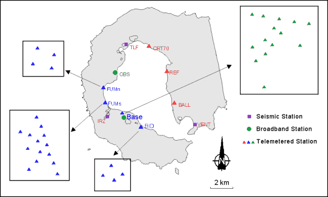 |
Figure 15. Seismic instruments deployed in the December 2000-March 2001 field survey of Deception Island. Seismic arrays are detailed in large squares. Courtesy of SAP. |
Seismicity is summarized in figure 16. Registered seismic events featured volcano-tectonic earthquakes (VT), a few episodes of volcanic tremor, long-period events (LP), and hybrid events (VT + LP). More than 75 VT, 500 LP, and 20 hybrid events were recorded; this constituted moderate activity compared to previous surveys. Hybrid events, which were difficult to detect in previous studies, peaked at the end of January 2001. Volcanic tremor episodes occurred with durations between hours and a few days; workers interpreted these events, together with the LP events, as a consequence of hydrothermal activity.
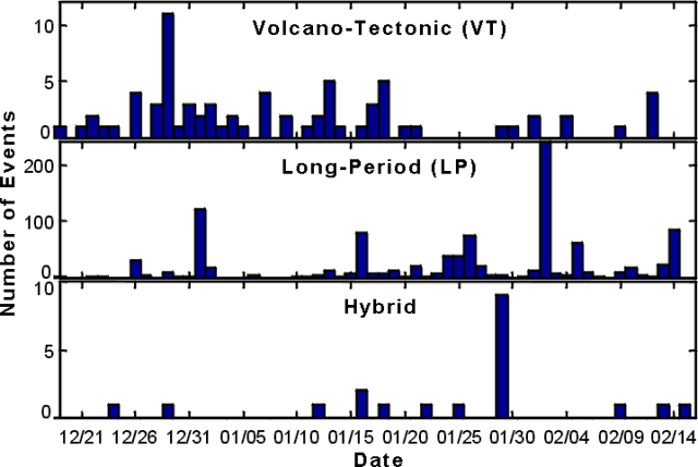 |
Figure 16. Histogram of the volcano-tectonic (VT), long period (LP), and hybrid events recorded during 20 December 2000-15 February 2001. Courtesy of SAP. |
The magnetic field in the area was monitored using a proton magnetometer deployed near the Argentinean base, which is the position used in previous surveys (figure 17). The recorded values of the magnetic field are being processed and corrected according to external variations in order to observe whether volcano-magnetic effects produced variation in the local magnetic field.
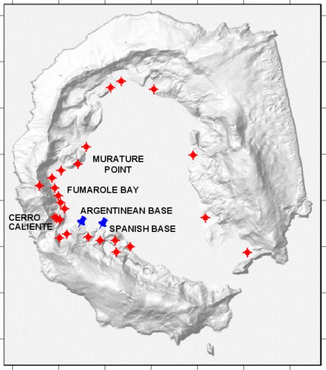 |
Figure 17. Map showing morphological features, bases, and the sites selected to measure CO2 flux. Courtesy of the SAP. |
Geochemical investigations consisted of recording gas composition and temperature of the fumaroles in Fumarole Bay and measuring CO2 flux at 26 points around the island (figure 16). The chemical analyses of the fumarolic samples are being processed. Fumarole temperatures averaged ~100°C, similar to values of previous years. The majority of points, including those bordering Fumarole Bay, had a very low flux of CO2. Two of them, however, Murature Point and Cerro Caliente hill (figure 17), had high fluxes. Future studies will conduct similar surveys in order to establish a CO2 flux map for the entire island.
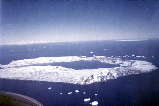
Geological Summary. Ring-shaped Deception Island, at the SW end of the South Shetland Islands, NE of Graham Land Peninsula, was constructed along the axis of the Bransfield Rift spreading center. A narrow passageway named Neptunes Bellows provides an entrance to a natural harbor within the 8.5 x 10 km caldera that was utilized as an Antarctic whaling station. Numerous vents along ring fractures circling the low 14-km-wide island have been reported active for more than 200 years. Maars line the shores of 190-m-deep Port Foster caldera bay. Among the largest of these maars is 1-km-wide Whalers Bay, at the entrance to the harbor. Eruptions during the past 8,700 years have been dated from ash layers in lake sediments on the Antarctic Peninsula and neighboring islands.
Information Contacts: Alicia García and Ramón Ortiz, Dpto. Volcanología, Museo Nacional de Ciencias Naturales, CSIC, José Gutierrez Abascal 2, 28006, Madrid, Spain; Jesús M. Ibáñez, Enrique Carmona, José Benito Martín, and Carmen Martínez, Instituto Andaluz de Geofísica, Apartado 2145, University of Granada, 18071 Granada, Spain; José Luis Pérez-Cuadrado, Universidad de Cartagena, 30202 Murcia, Spain; Mauricio Bretón, Universidad de Colima, Colima, Col., 28045, México; Mario La Rocca, Osservatorio Vesuviano, Via Diocleziano 328, 80124 Napoli, Italy.