Report on Kavachi (Solomon Islands) — November 2001
Bulletin of the Global Volcanism Network, vol. 26, no. 11 (November 2001)
Managing Editor: Richard Wunderman.
Kavachi (Solomon Islands) Daily eruptions August to mid-September 2001; eruption 27 November
Please cite this report as:
Global Volcanism Program, 2001. Report on Kavachi (Solomon Islands) (Wunderman, R., ed.). Bulletin of the Global Volcanism Network, 26:11. Smithsonian Institution. https://doi.org/10.5479/si.GVP.BGVN200111-255060
Kavachi
Solomon Islands
8.991°S, 157.979°E; summit elev. -20 m
All times are local (unless otherwise noted)
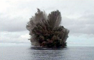
The last report (BGVN 25:04) described the submarine eruption that occurred in May 2000. During August through mid-September 2001, Corey Howell of the Wilderness Lodge (adjacent Peava village, Gatokae Island; 8° 47'S, 158° 14'E) reported that Kavachi erupted daily. During August ash and volcanic projectiles were observed rising ~400 m above sea level and the glow from the volcano was visible from the coast of Gatokae Island 32 km away. [According to Howell, the current phase of eruptive activity has been in progress since at least November 1999, with eruptions ranging from a minimum of once a week to eruptions from 5-15 minutes sustained over several days.]
Howell reported that activity waned in late September. As of 1 November no eruptive activity had been observed at Kavachi for about five weeks, but the observation post sat at the coast of Gatokae (also written Nggatokae) Island ~26 km NE of the volcano (see regional maps, CSLP Card 8028; BGVN 16:04). Low-level activity may have occurred that was not visible from the observation post.
A visit on 25 November revealed upwelling sulfur, mud, and tiny pieces of volcanic rock. The pieces of rock covered the sea surface over an area ~200 m across. A brownish green stain clouded the seawater. No explosive eruptions were seen during 6 hours of observation. Howell further noted that on 27 November Kavachi resumed explosive activity with columns reaching ~2 km high.
Reference. Johnson, W., and Tuni, D., Kavachi, 1987, An active forearc volcano in the western Solomon Islands: reported eruptions between 1950 and 1982, in Taylor, B., and Exon, N.F. (eds.), Marine geology, geophysics, and geochemistry of the Woodlark Basin, Solomon Islands: Circum-Pacific Council Energy Min Resour Earth Sci Ser, v. 7, p. 89-112.
Geological Summary. Named for a sea-god of the Gatokae and Vangunu peoples, Kavachi is located in the Solomon Islands south of Vangunu Island. Sometimes referred to as Rejo te Kvachi ("Kavachi's Oven"), this shallow submarine basaltic-to-andesitic volcano has produced ephemeral islands up to 1 km long many times since its first recorded eruption during 1939. Residents of the nearby islands of Vanguna and Nggatokae (Gatokae) reported "fire on the water" prior to 1939, a possible reference to earlier eruptions. The roughly conical edifice rises from water depths of 1.1-1.2 km on the north and greater depths to the SE. Frequent shallow submarine and occasional subaerial eruptions produce phreatomagmatic explosions that eject steam, ash, and incandescent bombs. On a number of occasions lava flows were observed on the ephemeral islands.
Information Contacts: Corey Howell, The Wilderness Lodge, PO Box 206, Honiara, Solomon Islands (URL: http://www.thewildernesslodge.org).