Report on Marapi (Indonesia) — January 2002
Bulletin of the Global Volcanism Network, vol. 27, no. 1 (January 2002)
Managing Editor: Richard Wunderman.
Marapi (Indonesia) Explosions during 2001; April ash plume reaches 2.0 km above the summit
Please cite this report as:
Global Volcanism Program, 2002. Report on Marapi (Indonesia) (Wunderman, R., ed.). Bulletin of the Global Volcanism Network, 27:1. Smithsonian Institution. https://doi.org/10.5479/si.GVP.BGVN200201-261140
Marapi
Indonesia
0.38°S, 100.474°E; summit elev. 2885 m
All times are local (unless otherwise noted)
On 11 March 2000, an explosion at Marapi ejected thick black ash that rose 1.4 km above the summit (BGVN 25:11). Explosive activity occurred again in 2001, peaking during 13-18 April, when a total of 150 explosions occurred that sent ash plumes to 2 km above the summit.
From January to February 2001, monthly A-type earthquakes had decreased from 15 to 8, and B-type earthquakes had decreased from 24 to 14. Gas-and-steam emissions, however, had increased from 11 events during January to 41 times during February. B-type earthquakes were registered on 7 April and continuous volcanic tremor occurred on 9 April.
On 14 April at 1600 a thick dark ash plume was visible from Bukittinggi, 15 km NW of Marapi's summit. On 16 April at 0600 an explosion sent a thick black ash plume to 700 m above the summit. At 0814 the same day a loud explosion was heard 8 km from the volcano, and a black mushroom-shaped ash plume rose to 2 km above the summit. Ejected incandescent fragments were seen clearly from Bukittinggi and then fell back to the crater rim. Ash fell over the villages of Sungai Puah, Air Angeh, and Andala, and in District X Koto, District Batipuh, District V Koto, Tanah Datar Regency, and Padang Panjang City in the zone S and SW of the summit. Ash deposits 1-4 km from the summit were 2-3 cm thick.
The Marapi Volcano Observatory increased the Alert Level from 1 to 2 following the activity that began on 13 April and a recommendation was issued by the local government to prevent people from traveling to the summit area.
Volcanic activity at Marapi continued through at least June 2001 (table 1). On 8 May at 2240, an explosion was accompanied by a moderate booming sound heard from the Tandikat observatory. Ash from the explosion spread to the NW, to Kota Bary, Padangpanjang, Lo Koto, and around the Tandikat observatory.
Table 1. Earthquakes and plumes reported at Marapi during 23 April-10 June 2001. Courtesy of VSI.
| Date | Deep volcanic (A-type) | Shallow volcanic (B-type) | Explosion | Tectonic | Observation (plume heights are above summit) |
| 23 Apr-29 Apr 2001 | 58 | -- | 30 | -- | Gray-black plume to 3.0 km; volcanic materials fell 4.0 km from volcano. Five explosion earthquakes were accompanied by loud noise. |
| 30 Apr-06 May 2001 | 27 | 22 | 4 | -- | Gray plume to 1.2 km above summit. |
| 07 May-13 May 2001 | 16 | 46 | 14 | 1 | Whitish-gray thick plume to 1.5 km above summit. |
| 04 Jun-10 Jun 2001 | 2 | -- | 2 | 2 | Explosion earthquakes had 33.6 mm maximum amplitudes. |
An explosion that began at 0445 on 5 June sent ash to the SSW. The ash was 0.5-2 mm thick in places. Merapi remained at Alert Level 2 through at least 10 June 2001.
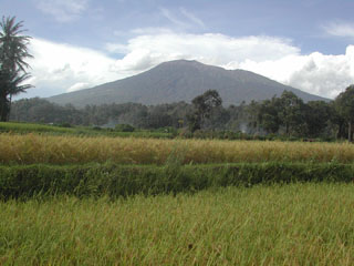
Geological Summary. Gunung Marapi, not to be confused with the better-known Merapi volcano on Java, is Sumatra's most active volcano. This massive complex stratovolcano rises 2,000 m above the Bukittinggi Plain in the Padang Highlands. A broad summit contains multiple partially overlapping summit craters constructed within the small 1.4-km-wide Bancah caldera. The summit craters are located along an ENE-WSW line, with volcanism migrating to the west. More than 50 eruptions, typically consisting of small-to-moderate explosive activity, have been recorded since the end of the 18th century; no lava flows outside the summit craters have been reported in historical time.
Information Contacts: Dali Ahmad, Volcanological Survey of Indonesia (VSI) (URL: http://www.vsi.esdm.go.id/).