Report on Etna (Italy) — March 2002
Bulletin of the Global Volcanism Network, vol. 27, no. 3 (March 2002)
Managing Editor: Richard Wunderman.
Etna (Italy) Overview of Etna's much-photographed July-August 2001 flank eruption
Please cite this report as:
Global Volcanism Program, 2002. Report on Etna (Italy) (Wunderman, R., ed.). Bulletin of the Global Volcanism Network, 27:3. Smithsonian Institution. https://doi.org/10.5479/si.GVP.BGVN200203-211060
Etna
Italy
37.748°N, 14.999°E; summit elev. 3357 m
All times are local (unless otherwise noted)
The last flank eruption at Etna occurred in 1993, but eruptive activity has been nearly continuous in the summit area since late July 1995. Unusually vigorous eruptions in early June 2001 (BGVN 26:08) were followed by still more energetic behavior. An earthquake swarm took place in mid-July, and large SSE-flank eruptions vented lavas in late July and early August on a scale not seen since 1983 (BGVN 26:09). Though this activity has been reported in previous Bulletin reports, what follows is a more detailed description of the summer 2001 activity.
Precursory phases. During the first half of 2001 most activity occurred at the Southeast Crater (SEC), starting with very slow lava extrusion from a vent on the NNE flank of its cone in late January. During the next three months the lava emission rate progressively increased and, in late April, weak ejections of lava fragments began to build small spatter cones (also known as hornitos) in the vent area. Strombolian activity resumed at the SEC's summit vent on 7 May, followed by an episode of vigorous Strombolian activity and lava fountaining two days later.
The activity then returned to lower levels, but for the next two months the SEC was the site of very picturesque continuous and persistent activity, with mild, discontinuous Strombolian explosions from the summit vent and vigorous lava emission (at times accompanied by lava spattering) from vent(s) on the NNE flank. At this spot, a large, steep-sided cone consisting of overlapping lava flows and spatter began to grow, and it was informally named "Levantino." From Levantino (figure 93, upper part), lava flowed NE (toward the Valle del Leone), E, and SE (toward the Valle del Bove), forming a composite lava field with numerous overlapping flow lobes. The longest flows extended up to 2 km from the vent(s). From late May to early June the continuous and relatively harmless activity attracted many visitors.
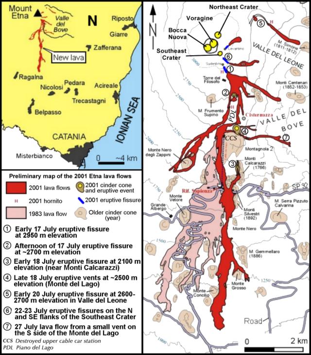 |
Figure 93. Inset map (upper left) and sketch map showing Etna's July-August 2001 lava flows, fissures, and related features. The 1983 lava flow-field on the S flank (lighter shading) is shown for comparison. The legend is also linked to numbers near the vents and fissures, as a way to indicate the sequence of activity. The pattern of activity lacked a simple spatial progression. For the time citations, note that the eruption occurred during daylight saving time (UTC + 2 hours). The sketch map is preliminary; it is a composite based on both fieldwork by Behnke and others, and already available maps appearing on the web, including those on the site of INGV-Sezione di Catania. Courtesy of Boris Behnke and Marco Neri, INGV. |
The prelude to the main eruption began in early June, with the first strong phase on 7 June, which was mostly confined to lava fountaining at the Levantino, whereas only mild Strombolian activity occurred at the SEC summit vent. During the following six weeks the vigor of the eruptive episodes gradually increased and at times culminated in true lava fountaining from the summit vent. Fourteen such episodes occurred between 7 June and 13 July (7, 9, 11, 13, 15, 17, 19, 22, 24, 27-28 and 30 June; 4, 7 and 13 July), ending with the most violent outburst of the series. Immediately after its cessation, vigorous seismicity began, including shocks that were felt as far as the cities of Acireale and Catania (figure 93 index map).
Between the early mornings of 13 and 17 July, about 2,600 tremors, mostly unfelt, were recorded instrumentally. During this same time interval, severe ground cracking and faulting occurred in various places on the W rim of the Valle del Bove and near the "Cisternazza" pit crater on the Piano del Lago ("PDL," figure 3), a flat area at ~2,500 m elevation to the N of the Montagnola. Press sources cited local volcanologists saying that magma was rising through a dike and stagnating about 1 km below the surface. Steaming was observed at some of the new fractures, but as of the late evening of 16 July no magma had reached the surface. Seismicity continued at a slightly decreased rate.
Shortly after midnight on 17 July, yet another paroxysmal episode occurred at the SEC. This was similar to its 13 July predecessor, with vigorous lava fountaining from the summit vent and the Levantino. It was the last event that could be considered part of the prelude to the main eruption. Figure 93 shows a sketch map of the lava flows that ultimately resulted from the July-August 2001 eruption. The inset at upper left shows the 2001 lavas and locations of various towns on Etna's S, SE, and E flanks.
Eruption of 17 July-9 August 2001. As defined here, the main eruption lasted nearly 24 days, from early 17 July to late 9 August 2001. It began a few hours after the last paroxysmal eruptive episode at the SEC.
An eruptive fissure opened at about 0700 on 17 July at the SSE base of the SEC at ~ 2,950 m elevation (point 1 on figure 93). Vigorous lava spattering occurred at a number of vents, while lava flows advanced toward SE, in the direction of the Valle del Bove rim. Several hours later, at 2200, another fissure opened at an elevation of ~ 2,700 m (point 2 on figure 93), a bit to the W of a panoramic point on the W rim of the Valle del Bove known as "Belvedere," and lava began to extend S from there, across the Piano del Lago, and in the direction of the cable car and ski lifts (shown by the vertical dotted line just beneath PDL on figure 93).
At 0120 on 18 July, a third eruptive fissure became active on the S flank of the Montagnola at ~ 2,100 m elevation, slightly uphill of the Monti Calcarazzi (point 3 on figure 93). Activity at this fissure was initially weak, and a sluggish lava flow began to move from the lower end of the fissure toward the Monte Silvestri superiore, a large complex cinder cone formed in 1892. During the day, the activity gradually increased; lava flowed around the W side of the Monte Silvestri, crossed the road (which connected the Rifugio Sapienza-cable car area with the town of Zafferana) and passed close to buildings. By late evening on 18 July the flow front was at 1,800 m elevation. On 19 July, the lava flow fed by the vents at 2,100 m elevation continued to pass between numerous older cinder cones along the E margin of the 1983 lava flow-field. At the same time eruptive activity continued unabated at all eruptive fissures.
On the evening of 19 July at about 1900, a new vent opened on the Piano del Lago at ~2,570 m elevation, ~ 500 m N of the Montagnola (point 4 on figure 93; "Montagnola 2", "Monte del Lago" or "Cono del Laghetto", unfortunately, all three names are in common usage). The activity was characterized by violent phreatomagmatic explosions that produced a black, ash-laden column and ejected large blocks of older volcanic rocks. This phreatomagmatic activity might have been the result of magma-water interactions with shallow ground water. (The name, Piano del Lago, the "plain of the lake," derives from the fact that frequently during the spring snow-melt a small meltwater lake had formed in that area.) To observers familiar with footage of the 1963 Surtsey (Iceland) eruption, the steam-and-ash columns rising from the new vent appeared strikingly similar. After nightfall spectacular lightning flashed through the plume and ash fell over inhabited areas including the NE, E, SE, and S flanks. Close observation of the vent at 2,570 m elevation revealed a simple, though constantly eroding, pit. Rumors spread that the pit would eventually "make the Montagnola cave in;" however, it remained intact.
The front of the lava flow emitted at 2,100 m elevation (point 3 on figure 93) was at 1,350 m late on the evening of 19 July. It still advanced vigorously, though at reduced speed (~45 m/hour). Soon after, authorities declared a state of emergency.
By the evening of 20 July the front of the lava flow had reached 1,220 m elevation, but it had slowed in a gently sloping area. Nonetheless, the threat to Nicolosi had become international news. The main risk now came from forest and bush fires. Helicopters began to drop large quantities of water onto the burning forest (not onto the lava flow, as was widely reported). Fortunately, no fires broke out. By late 21 July the lava flow's front had reached 1,050 m elevation.
During the night of 19-20 July, the SEC reactivated, and lava began to issue from the NNE side of the Levantino, forming a small flow that advanced in the direction of the Valle del Bove.
At about 1100 on 21 July, yet another eruptive fissure formed (point 5 on figure 93). It emerged on the NE flank, far away from the earlier fissures (below the Pizzi Deneri on the floor of the Valle del Leone). Figure 93 portrays the impressive arcuate fracture system that developed. The lava first issued from the fissure's uppermost portion at ~ 2,700 m elevation, then from its eastern extension ~50 m further downslope. A fracture system formed between this northeasternmost fissure and the E side of the summit crater area, and fissures up to 1 m wide opened on the slope between the Bocca Nuova and the SEC, and began emitting dense vapor plumes.
The large pit crater on the Piano del Lago at 2,570 m elevation continued to produce dense, ash-laden plumes. In late July ash fell over the area between Zafferana and Acireale (inset, figure 93).
On 21 July, the eruption continued with unabated vigor at all eruptive fissures. Late that day, the lava from the vents at 2,700 m had not further advanced on the steep slope above the tourist complex of the Rifugio Sapienza area (shown as Rif. Sapienza, figure 93).
The next day, 22 July, a shift in the wind direction drove the dense ash plume produced by the phreatomagmatic vent at 2,570 m elevation directly over the Catania area, paralyzing the city's Fontanarossa International Airport, and dropping large amounts of fine, black, sand-sized tephra over streets and buildings. Eruptive activity continued without significant variations at all fissures, although the main lava flow directed toward Nicolosi had slowed significantly and advanced only a few meters per hour, still 4 km from the outskirts of the town. That evening, minor, though fast-moving lava tongues fed by the vents at 2,700 m elevation spilled down the steep slope above the tourist complex, destroying part of the ski lifts and threatening to overwhelm some of the poles of the cable car. However, none of these flows made it further than about halfway down that slope. Vigorous Strombolian activity continued at the fissure at 2,100 m elevation, and a cone about 20-30 m high had formed around the largest of its vents, while minor lava spattering from four vents in the lower part of the fissure was building a low-spatter rampart. The lava flow from this fissure moved as a single, broad unit (point 6 on figure 93). Throughout 23 July the activity showed little variation.
On 24 July it became clear that something was changing at the Piano del Lago crater, which until then had displayed only phreatomagmatic activity. Loud detonations came from the Piano del Lago vent on the morning of 25 July, as the activity there had now become purely magmatic.
A new cone was growing on the former Piano del Lago on 26 July produced near-continuous explosions accompanied by loud detonations that could be heard ten's of kilometers away. The cone received bombs ejected from at least three vents within it. Lava began flowing from vents on its S and N sides, spilling around the N and NW sides of the Montagnola and down the steep slope on the W side of that cone toward the Rifugio Sapienza. The new lava flow passed E of the lower cable car station, covered another portion of the road and advanced a few hundred meters further. Vigorous eruptive activity continued on 26 July at the eruptive fissure at 2,950 m elevation, while the fissure at 2,700 m elevation continued to emit lava but pyroclastic activity there had ended. Weak activity continued at the Valle del Leone fissure, with lava flowing toward Monte Simone (in the N part of the Valle del Bove), and the fissure at 2,100 m elevation showed no significant changes in its activity with respect to the previous days.
During 27-30 July the eruption produced some outstanding displays (figures 94 and 95) and caused the greatest impact on human structures. While the fissure in the Valle del Leone showed ever-lower levels of activity and the fissures at 2,900, 2,700, and 2,100 m elevation continued to erupt in a manner almost identical to the previous days, the Montagnola 2 cone and several nearby vents not only provided a show, but vents on its N and S flanks delivered vigorous lava flows that spilled down the steep slope to the W of the Montagnola in surges, presenting a continuous threat to the Rifugio Sapienza area.
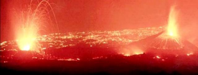 |
Figure 94. At Etna, a night view taken from high on the S flanks near Torre del Filosofo documenting the erupting vents at 2,700 m elevation (left) and a lava fountain at the Piano del Lago cone (right), probably taken on 30 July 2001. The camera was aimed SE. Lights of towns between Acireale and Giarre are visible in the background. Photo was published in the 1 August 2001 issue of the "La Sicilia" newspaper. |
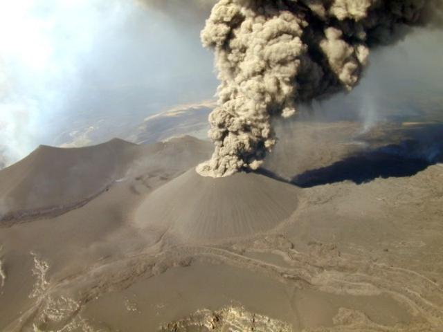 |
Figure 95. Spectacular aerial view of the largest cone formed in Etna's eruption during July-August 2001, built on what used to be the "Piano del Lago" at ~ 2,500 m elevation on the S flank. View is to the SW. Most of the cone grew in a few days in late July; this photo shows the waning phase around 2 August when only ash was emitted. After the end of the activity the summit of the cone stood nearly 100 m higher than its base, but then partially collapsed leaving the cone ~ 80 m higher. To the left of the cone is the 1763 Montagnola crater. Between the two lies a fuming vent; it emitted one of the latest lava flows in the area (black ribbon extending to the left margin of the photo). Other lava flows that were emitted from vents at ~ 2,700 m elevation (out of the photo to the right) can be seen in the right foreground. Yet another lava lobe extends toward the lower left corner of the photo; it emerged at the E base of the Piano del Lago cone. Photograph by volcanologists of the INGV (National Institute of Geophysics and Volcanology); published on 6 August 2001 in the "La Sicilia" newspaper. |
A lava flow from the southern base of the Piana del Lago cone on 27 July remained active for about 2 days (point 7 of figure 93). This cone produced three distinct lava flow units from three different vents on its SW, S, and NW sides; those from the SW vent were the most damaging. On the evening of 30 July, the eruption claimed the upper cable car station, which burst into flames as a tongue of lava invaded its interior. Behind it, the rapidly growing cone of the Piano del Lago sent its lava fountains hundreds of meters into the sky, producing ground-shaking detonations.
During late July, the rate of lava emission in the direction of the Rifugio Sapienza area diminished as a new vent opened on the S side of the Piano del Lago cone, from which a lava flow spilled over the crest of the Valle del Bove and flowed to the bottom of the Valle, covering a portion of lava erupted in 1991-1993. The Valle del Leone fissure ceased emitting lava. The Montagnola 2 had become a large cone. It again shifted from magmatic to phreatomagmatic activity. Although the level of activity at this cone was decreasing, ash columns developed, and the wind carried the ash again in the direction of Catania, again closing the Fontanarossa airport. Vigorous eruptive activity continued during the first days of August at the fissure at 2,100 m elevation, but the lava effusion rate had dropped, and only the central portion of the original flow remained active, feeding a flow that advanced on top of the larger earlier flow from the same fissure. Strong phreatomagmatic explosions occurred from time to time at the upper vents on this fissure. Lava also continued to pour from the fissure at 2,700 m elevation, and numerous active flow lobes extended SE toward Monte Nero.
Beginning on 3 August the activity at the fissure at 2,100 m elevation showed a marked decrease. During the last week of the eruption (4-10 August) lava continued to flow from that fissure at a rapidly diminishing rate, explosive activity ended, and the fissures at 2,950 and 2,700 m elevation ceased erupting. Ash emission from the Piano del Lago cone ended around 6 August. Lava was last seen flowing from the fissure at 2,100 m elevation on late 9 or early 10 August. The eruption ended after almost 24 days, much earlier than its vigorous onset had suggested.
Products of the eruption and morphological changes. The July-August 2001 eruption emitted at least eight distinct lava flows which mostly affected the S and SSW flanks of Etna. The most damaging flows came from vents near the Piano del Lago cone at 2,570 m elevation. This cone produced most of the pyroclastic material, of which the most fine-grained portion (ash) caused widespread distress.
Petrographically, the lavas fall into two main groups, one of which is essentially similar to the historical products of Etna (porphyric hawaiites with phenocrysts of plagioclase, clinopyroxene and olivine), while the other shows characteristics not seen in any Etnean lavas during the past millennia (alkalic basalts).
Several major pyroclastic edifices grew during the eruption. The largest, the Piano del Lago cone at ~2,570 m elevation, is a nearly symmetrical cone, ~80 m high, which grew mostly between 25 and 31 July. It is crowned by a large crater ~150 m across and 50-60 m deep with near-vertical walls. During a visit on 30 August a few fumaroles located on the SEC walls emitted vapor and gas without forming a visible plume. A spectacular dike was exposed at the base of the E crater wall, and a less conspicuous dike was visible at the base of the WNW crater wall. Several faults or groups of faults were visible in the E and NE crater walls; a narrow graben developed on top of the E crater wall dike. The second-largest pyroclastic edifice lies in the upper part of the fissure at 2,100 m elevation.
Extensive (non-eruptive) fracture systems formed between the various eruptive fissures. Some of them began to form before the eruption, others developed during its first week. Many of these fractures are arranged in an en echelon pattern, which is especially notable in the Valle del Leone, between the northeastern (2,600 m) vents and the SEC. Other spectacular fractures opened between the Piano del Lago cone and the eruptive fissure at 2,100 m elevation. However, the most impressive fractures developed on the E side of the former Central Crater (now occupied by the Voragine and the Bocca Nuova), where they attained widths of more than 1 m. These fractures were vigorously steaming when visited in late-August and mid-September 2001. Fracturing also affected the southern face of the SEC cone.
About 5.5 km2 of Etna's upper and middle slopes were covered with new lava (compared to 7.6 km2 in the 1991-1993 flank eruption). The total volume of lavas and pyroclastics emitted during the eruption is ~ 30-35 x 106 m3 (25 x 106 m3 of lava and 5-10 x 106 m3 of pyroclastics, all calculated as dense rock equivalent), which makes this eruption a relatively modest-sized one for Etna (the 1991-1993 eruption had produced ~ 235 x 106 m3 of lava). Yet the fairly high proportion of pyroclastic material distinguishes this eruption from most other recent Etnean flank eruptions.
The most productive vents were those at 2,100 m elevation, which produced the longest (~ 7 km) and most voluminous (slightly less than 14 x 106 m3) single lava flow. The average combined effusion rate at all eruptive fissures throughout the eruption was ~11 m3/s, with peak rates of 14-16 m3/s. It is assumed that much of the magma that accumulated in one or more reservoirs below the base of the volcano in the years preceding the eruption was not erupted and remains available for future eruptions.
Geological Summary. Mount Etna, towering above Catania on the island of Sicily, has one of the world's longest documented records of volcanism, dating back to 1500 BCE. Historical lava flows of basaltic composition cover much of the surface of this massive volcano, whose edifice is the highest and most voluminous in Italy. The Mongibello stratovolcano, truncated by several small calderas, was constructed during the late Pleistocene and Holocene over an older shield volcano. The most prominent morphological feature of Etna is the Valle del Bove, a 5 x 10 km caldera open to the east. Two styles of eruptive activity typically occur, sometimes simultaneously. Persistent explosive eruptions, sometimes with minor lava emissions, take place from one or more summit craters. Flank vents, typically with higher effusion rates, are less frequently active and originate from fissures that open progressively downward from near the summit (usually accompanied by Strombolian eruptions at the upper end). Cinder cones are commonly constructed over the vents of lower-flank lava flows. Lava flows extend to the foot of the volcano on all sides and have reached the sea over a broad area on the SE flank.
Information Contacts: Boris Behncke, Dipartimento di Scienze Geologiche (Sezione di Geologia e Geofisica), Palazzo delle Scienze, Corso Italia 55, 95129 Catania, Italy.