Report on Soufriere Hills (United Kingdom) — June 2002

Bulletin of the Global Volcanism Network, vol. 27, no. 6 (June 2002)
Managing Editor: Richard Wunderman.
Soufriere Hills (United Kingdom) During 19-29 February large spines and plumes occurred at tidal maxima
Please cite this report as:
Global Volcanism Program, 2002. Report on Soufriere Hills (United Kingdom) (Wunderman, R., ed.). Bulletin of the Global Volcanism Network, 27:6. Smithsonian Institution. https://doi.org/10.5479/si.GVP.BGVN200206-360050
Soufriere Hills
United Kingdom
16.72°N, 62.18°W; summit elev. 915 m
All times are local (unless otherwise noted)
Stephen O'Meara and four Volcano Watch International (VWI) team members (Robert Benward, Tippy D'Auria, Scott Ireland, and Larry Mitchell) visually monitored Soufrière Hills for 10 days beginning on 19 February 2002. The observations took place on Jack Boy Hill, a spot at ~180 m elevation 6 km N of the volcano. In addition, for 3 hours on the night of 25 February, the group joined Montserrat Volcano Observatory (MVO) scientists Peter Dunkley and Richard Herd on the runway at Bramble Airport. Except for a storm on 20 February, the weather facilitated exceptionally clear views of the dome during both day and night. The team employed a variety of telescopes and other optical equipment and had an interest in astronomy as well as the volcano (O'Meara, 2002).
Benward brought along a homemade night-vision scope (near-infrared image intensifier) that captured images of the dome, even through local atmospheric conditions where visible light was weakened or scattered. The intensifier was coupled to camera lenses. It could be used visually or attached to a video camera (figure 47). The camera's phosphor viewing screen yielded green-colored images of the hot portions of the dome.
 |
Figure 47. The night-vision scope (image intensifier) put together by Robert Benward and used to obtain images of Soufriere Hills' growing dome. In this configuration the intensifier lies between two other components: a telephoto camera lens (left) and a video camera (right). Courtesy of Steve O'Meara, Robert Benward, and Sky and Telescope magazine. |
One purpose of the VWI team's visit to Montserrat was to chronicle changes in the volcano's visible behavior with approach to the time of the full Moon and its perigee (when the Moon is closest to the Earth). The idea was that the tidal influence associated with the full Moon and its perigee might lead to enhanced activity. With approach of the full Moon, there did seem to be a rise in visible indicators, particularly plume height, a strong pulse of extruded spines, and less-substantial increases in the numbers of rockfalls and pyroclastic flows.
As background on tidal forces, the paths of both the Moon around the Earth, and Earth around the Sun are elliptical throughout the lunar cycle (29.53 days) and solar cycle (the year), meaning that the separations and resulting gravitational forces vary with time. The Earth-Moon separations change by ~50,000 km; when they are smallest (perigee) and largest (apogee) the respective tidal forces are higher or lower than usual. In addition, the gravitational attractions of Moon and Sun on the Earth may act along a common line or at changing angles relative to each other. Particularly large tides affect the Earth's crust and oceans when the Sun and the Moon are lined up with the Earth; this occurs at the new and full phases of the Moon. These orientations lead to what are called spring tides (a name not associated with the season of Spring, but which implies a "welling up"). The amount of tidal enhancement is roughly the same whether the Sun and Moon are lined up on opposite sides of the Earth (full Moon) or on the same side of the Earth (new Moon). In contrast, when the Moon is at first quarter or last quarter (meaning that it is located at right angles to the Earth-Sun line), the Sun and Moon produce tidal bulges called neap tides. These are generally weaker than the above-described spring tides.
A two-month record of seismicity and tides at the volcanically active Axial seamount on the Juan de Fuca ridge during 1994 found both bi-weekly and diurnal patterns in earthquakes and volcanic tremor (Tolstoy and others, 2002). The authors concluded that microearthquakes took place at tidal minima.
Montserrat, Moon, and magma. The full Moon occurred at 0518 on 27 February; perigee, ~11 hours later, at 1630. The team's 10-day stay was too short to see more than a partial lunar cycle, but soon after full Moon and perigee, the numbers for the observed visible indicators appeared to drop considerably.
After an initial study of dome activity on 19 February and a storm on 20 February, the group began taking regular visible observations on 21 February. At that time, activity appeared to be on the increase and a high-level of activity was sustained throughout the observation period. According to MVO: "The level of volcanism at Soufrière Hills during 22 February-1 March was higher than it had been in previous weeks." The growing dome was quite active, displaying near continuous rockfall and small pyroclastic flows, most of which traveled E to the Tar River Valley, though some activity was directed to the S and W. During the 10-day observation interval, the dome also rapidly extruded very large spines.
By midnight on 27 February the team had recorded and tabulated 440 observations of notable rockfalls and pyroclastic flows. On the whole during this interval, the number of these events per hour stood well below 10, typically ranging from ~4 to ~8. One low, late on 23 February, only reached 1 event per hour. The average number of these events per hour reached a low of ~5 during 21-23 February rising to ~8 on 27 February. The highest hourly total recorded during the observing period occurred on 27 February with 13 of these events during 0000-0100 and 10 during 1120-1320. These times fall on either side of the full Moon; the second total lies at the midpoint between the full Moon and lunar perigee.
Visible activity decreased sharply on 28 February. The team, which departed on 3 March, made sporadic observations until 1 March. Their observations on and after 28 February suggested dome activity had remained substantially lower than during 21-27 February.
During their interval of observation the team found a direct correlation between the number of large visible events and the size of the dome's emerging and collapsing spines. The mass of each spine also increased during the observation period; the largest spine was observed on 26 February, the day before the full Moon and perigee.
Each of the spines collapsed in less than a day, only to regrow rapidly. The largest (shown on figures 48-53) reached 90 m tall; it enabled the summit to attain 1,080-m elevation, the highest the summit has been during the entire eruption to date (according to the MVO weekly update). It grew rapidly; specifically, it was not present from 1830 to 2100 on the evening of 25 February, but was fully grown by 0600 the following morning. When seen at 0330 on 26 February the new spine appeared as an incandescent obelisk about one-fifth its maximum size. The majority of this massive spine then grew to its record height in 3 hours.
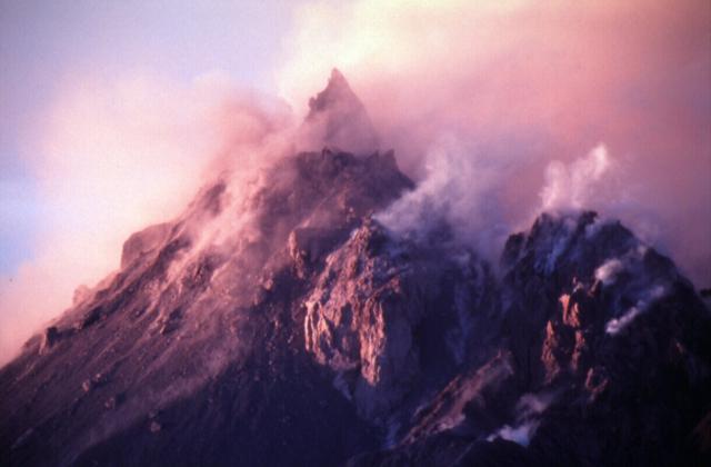 |
Figure 48. A S-view taken from Jack Boy Hill of Soufrière Hills dome shown with the yet-highest-reaching spine seen to date, which was photographed shortly after sunrise on 26 February 2002. The spine appears as a triangular peak at the summit; it soon began to collapse. Courtesy of Steve and Donna O'Meara, Volcano Watch International. |
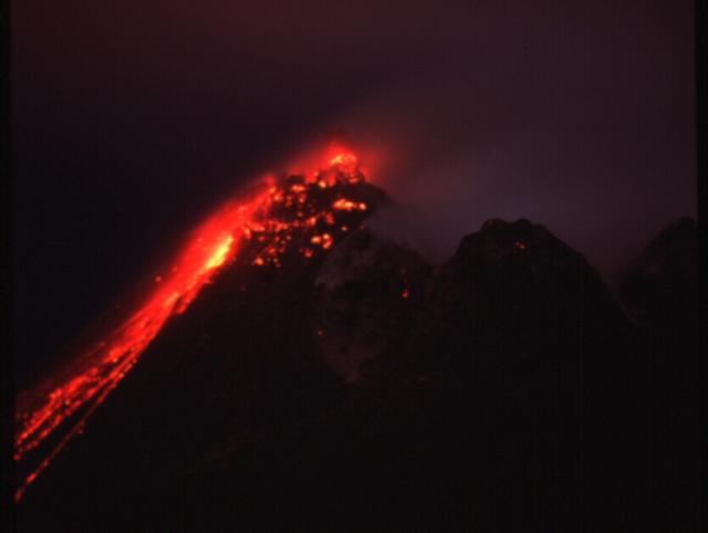 |
Figure 49. A S-looking night shot taken from Jack Boy Hill at 0300 on 26 February that depicts Soufriere Hills in a highly incandescent state, with a large and growing spine extruding out of the top of the dome. Disrupted and displaced dome materials, including falling blocks, incandescent rockfalls, and pyroclastic flows, have left a conspicuous apron of hot material on the dome's left (W) side. Surprisingly little ash and steam appear to be present. Courtesy of Steve and Donna O'Meara, Volcano Watch International. |
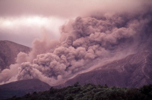 |
Figure 50. A daytime shot taken from Jack Boy Hill showing part of a comparatively large pyroclastic flow at Soufriere Hills on 24 February 2002. Courtesy of Steve and Donna O'Meara, Volcano Watch International. |
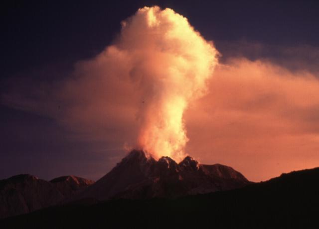 |
Figure 51. The ragged summit of the dome at Soufriere Hills as it lies beneath a small plume at sunset. Taken from Jack Boy Hill looking S on 25 February 2002. Courtesy of Steve and Donna O'Meara, Volcano Watch International. |
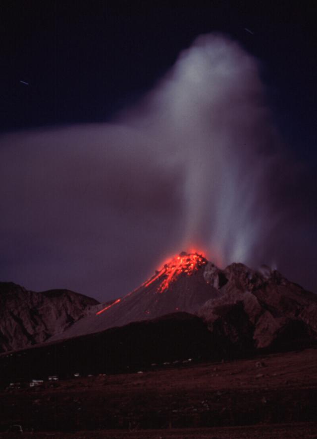 |
Figure 52. A night shot of the dome at Soufriere Hills showing the summit dome that was soon to extrude a large spine (not yet visible). This photo was taken from the airport (several kilometers NE of the dome) in conditions of moonlight on 25 February at about 2100. Courtesy of Steve and Donna O'Meara, Volcano Watch International. |
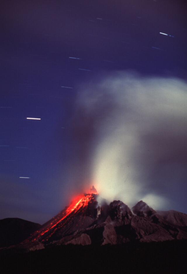 |
Figure 53. Soufriere Hills' glowing dome showing triangular spine in the moonlight with stars in the night sky. Taken from the airport (several kilometers NE of the dome). Courtesy of Steve and Donna O'Meara, Volcano Watch International. |
Figure 54 is one of several plots constructed to illustrate the results. It was made by omitting the smaller events, which the team judged from small to medium using a qualitative visual scale that ran from S1 to S3 and continued upwards from M1 to M3 (where event sizes are abbreviated as S for "small" and M for "medium" and termed as S-class or M-class, respectively). Thus, the largest events seen were M3 (i.e., they saw no events in these time periods that they classified as "large"). On their scale, events of size S3 and M1 were judged to be of very similar magnitude. Figure 54 shows the increase in larger event size seen during 21-26 February, culminating in the highest numbers late on 26 February to early on 27 February.
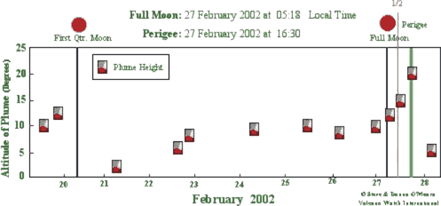 |
Figure 54. A plot of the number of larger observed rockfall and pyroclastic-flow events seen at Soufrière Hills during 21-27 February 2002. The events counted in this plot excluded the smallest two categories (S1 and S2 classes, see text). High tides were shown (thin vertical lines) for those cases where they occurred during an interval in which observations were conducted; otherwise they are absent. The symbols along the top of the plot indicate processes described in the key. The symbol sizes were increased or reduced for events judged to be of larger or smaller size. For example, the largest spine grew on 26 February (large dark triangle). Courtesy of Steve and Donna O'Meara, Volcano Watch International. |
Figure 54 shows six high tides that occurred at times when observations were conducted (on 21, 22, 24, 26 and 27 February). Five of the six of these tides coincided with observation intervals with the day's highest number of the largest events (the M-class events).
Plume height. As shown on figure 55, an increase in plume height took place around the time of first quarter Moon followed by a decrease, then a gradual rise in plume height, until it reached a maximum at the time of perigee on 27 February. Although atmospheric conditions could clearly affect the extent and height of a plume, the team found the pattern of the plotted data compelling. The plot may disclose tidal effects.
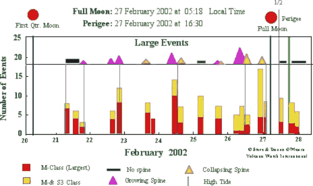 |
Figure 55. Plume heights (in degrees above a reference horizon) at Soufriere Hills plotted against time as observed during 19-28 February 2002. Courtesy of Steve and Donna O'Meara, Volcano Watch International. |
References. O'Meara, S., 2002, Firelight nights: Stargazing from the Caribbean's Emerald Isle; A group of American amateur astronomers helps residents of Montserrat and its neighboring island explore the universe: Sky & Telescope, August 2002, p. 79-83.
Tolstoy, M., Vernon, F.L., Orcutt, J.A., and Wyatt, F.K., 2002, Breathing of the seafloor, tidal correlations of seismicity at Axial Volcano: Geological Society of America (GSA), Geology, v. 30, no. 6, p. 503-506.
Geological Summary. The complex, dominantly andesitic Soufrière Hills volcano occupies the southern half of the island of Montserrat. The summit area consists primarily of a series of lava domes emplaced along an ESE-trending zone. The volcano is flanked by Pleistocene complexes to the north and south. English's Crater, a 1-km-wide crater breached widely to the east by edifice collapse, was formed about 2000 years ago as a result of the youngest of several collapse events producing submarine debris-avalanche deposits. Block-and-ash flow and surge deposits associated with dome growth predominate in flank deposits, including those from an eruption that likely preceded the 1632 CE settlement of the island, allowing cultivation on recently devegetated land to near the summit. Non-eruptive seismic swarms occurred at 30-year intervals in the 20th century, but no historical eruptions were recorded until 1995. Long-term small-to-moderate ash eruptions beginning in that year were later accompanied by lava-dome growth and pyroclastic flows that forced evacuation of the southern half of the island and ultimately destroyed the capital city of Plymouth, causing major social and economic disruption.
Information Contacts: Steve and Donna O'Meara, Robert Benward, Tippy D'Auria, Scott Ireland, and Larry Mitchell, Volcano Watch International, PO Box 218, Volcano, Hawaii 96785.