Report on Witori (Papua New Guinea) — August 2002
Bulletin of the Global Volcanism Network, vol. 27, no. 8 (August 2002)
Managing Editor: Richard Wunderman.
Witori (Papua New Guinea) Eruption that began on 3 August 2002 continues through at least mid-September
Please cite this report as:
Global Volcanism Program, 2002. Report on Witori (Papua New Guinea) (Wunderman, R., ed.). Bulletin of the Global Volcanism Network, 27:8. Smithsonian Institution. https://doi.org/10.5479/si.GVP.BGVN200208-252080
Witori
Papua New Guinea
5.5745°S, 150.5161°E; summit elev. 724 m
All times are local (unless otherwise noted)
The eruption that began at Pago on 3 August 2002 (BGVN 27:07) continued through at least mid-September. The Darwin VAAC reported that on 14 August around 1030 a very thin, low-level ash plume was visible on satellite imagery. The plume extended N to NNW from Pago and was probably below ~2.1 km altitude. On 16 August, intermittent eruptions with low ash content produced low-level plumes.
The United Nations Office for the Coordination of Humanitarian Affairs (OCHA) reported on 16 August that small earthquakes and tremors had occurred in early July and as of 5 August the volcano was ejecting thick dark gray ash and sulfurous fumes. The Rabaul Volcanological Observatory (RVO) reported that five vents on the NW flank were active and releasing short lava flows in the crater. RVO indicated that the eruptions were of small magnitude, but the situation could deteriorate rapidly. More than 10,000 people were evacuated from villages surrounding Pago to the provincial capital of Kimbe, 50 km N of the volcano. Airports in Kimbe and in nearby Hoskins were closed due to ashfall. OCHA reported that, should the eruption continue, local crops could be severely damaged by ash.
On 21 August several news articles reported that surface deformation had been recorded at Pago by RVO staff. They also reported that Ima Itikarai, a RVO seismologist, stated that lava appeared to be topographically constrained within the Witori caldera.
MODIS imagery on 22 August showed a NNW-trending plume coming from Pago. An image that day disclosed a narrow, cigar-shaped plume conspicuous for ~20 km, becoming broken and extending for perhaps another ~20 km.
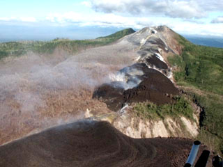
A Japanese Disaster Relief Team visited Pago during 25 August-3 September and provided a brief initial report and sensational photos of the scene there (figures 2 and 3), showing abundant lava emitted from a series of vents. Figures 2 and 3 show the NW-SE alignment of vents extending radially NW from the central vent. The Team found that lava had erupted from four of the five emission points NW of the central vent.
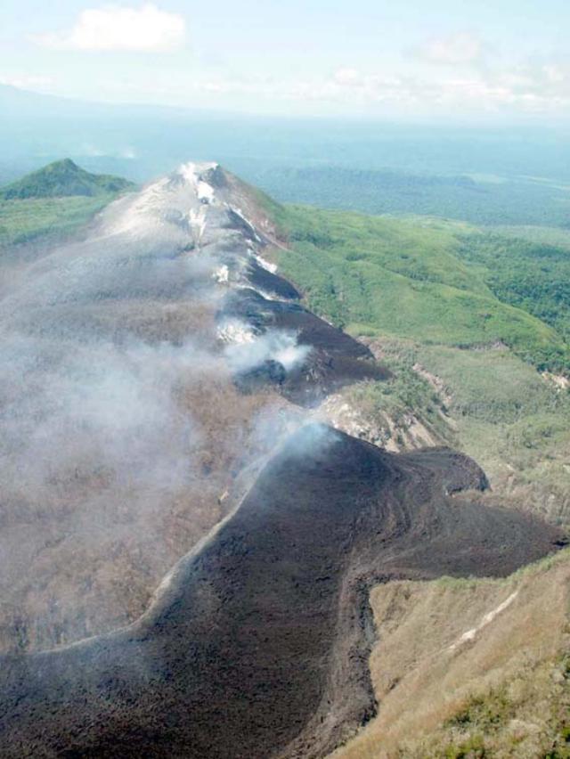 |
Figure 2. NW view showing the chain of vents and the new lava flows at Pago taken during the 28-29 August 2002 visit of the Japanese Disaster Relief Team. Courtesy Mitsuhiro Yoshimoto, VRC-ERI. |
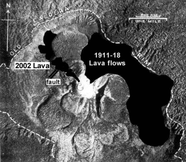 |
Figure 3. Vertical photo showing distribution of new lava flows from August 2002, compared with the previous lava flows from the 1911-18 eruption. Courtesy Mitsuhiro Yoshimoto, VRC-ERI. |
The Team noted that the largest quantity of lava was emitted from the outermost and lowest vent. Lava discharged there flowed hundreds of meters NNW, and then, after it encountered the Witori caldera's wall, it began advancing NE and SW. Lava flowing NE was constrained by both the caldera's wall and an older, large, sub-circular flow on its E side (figure 3). Lava-flow composition and other details will be discussed in future reports.
Two faults were visible; one was parallel to the line of craters, and the other was perpendicular to it (figure 3). No eruption column was observed, only blue-white fumarolic gas was emitted. The thickest ash deposits the Team saw were 2 mm thick 3 km N of the craters, and less than 1 mm thick at Hoskins airport.
A satellite image on 6 September 2002 showed a NW-trending plume from Pago (figure 4). The Darwin VAAC reported that on 7 September at 0656 a low-level (~1.5 km altitude) ash-and-steam plume was visible on satellite imagery drifting NW. A news article reported that an explosive event occurred at Pago during 7-8 September. Another news article reported that monitoring equipment coming from the US and Japan would serve to monitor volcanoes in the region, including Pago.
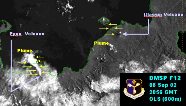 |
Figure 4. Satellite imagery taken on 6 September 2002 at 2056 (UTC) shows a NW-trending plume from Pago. The plume is conspicuous for 30-40 km, dispersing over Kimbe Bay and the Bismark Sea. A smaller and less distinct plume can be seen coming from Ulawun to the ENE. Courtesy US Air Force Weather Agency. |
Geological Summary. The active Pago cone has grown within the Witori caldera (5.5 x 7.5 km) on the northern coast of central New Britain contains the active Pago cone. The gently sloping outer caldera flanks consist primarily of dacitic pyroclastic-flow and airfall deposits produced during a series of five major explosive eruptions from about 5,600 to 1,200 years ago, many of which may have been associated with caldera formation. Pago cone may have formed less than 350 years ago; it has grown to a height above the caldera rim, and a series of ten dacitic lava flows from it covers much of the caldera floor. The youngest of these was erupted during 2002-2003 from vents extending from the summit nearly to the NW caldera wall. The Buru caldera cuts the SW flank.
Information Contacts: Ima Itikarai, Rabaul Volcano Observatory (RVO), PO Box 386, Rabaul, E.N.B.P., Papua New Guinea; Japanese Disaster Relief Team, including these three members: (a)Kohichi Uhira, Volcanological Division, Seismological and Volcanological Department, Japan Meteorological Agency, 1-3-4 Ote-machi, Chiyoda-ku, Tokyo 100-8122 Japan, (b)Akimitsu Takagi, Meteorological Research Institute of Japan Meteorological Agency, 1-1 Nagamine, Tsukuba, Ibaraki 305-0052 Japan, and (c)Mitsuhiro Yoshimoto, Volcano Research Center (VRC), Earthquake Research Institute (ERI), University of Tokyo, 113-0032 1-1-1, Yayoi, Bunkyo-ku, Tokyo (URL: http://www.eri.u-tokyo.ac.jp/VRC/index_E.html); Darwin Volcanic Ash Advisory Center (VAAC), Bureau of Meteorology, Northern Territory Regional Office, PO Box 40050, Casuarina, NT 0811, Australia (URL: http://www.bom.gov.au/info/vaac/); United Nations Office for the Coordination of Humanitarian Affairs (OCHA), United Nations, New York, NY 10017 USA (URL: http://www. reliefweb.int); Charles Holliday, Air Force Weather Agency (AFWA), Satellite Applications Branch, Offutt AFB, NE 68113-4039; Reuters; Associated Press; Australian Associated Press; Papua New Guinea Post Courier; The National.