Report on Etna (Italy) — October 2002
Bulletin of the Global Volcanism Network, vol. 27, no. 10 (October 2002)
Managing Editor: Richard Wunderman.
Etna (Italy) A flank eruption started on 27 October; lava vented at N- and S-flank fissures
Please cite this report as:
Global Volcanism Program, 2002. Report on Etna (Italy) (Wunderman, R., ed.). Bulletin of the Global Volcanism Network, 27:10. Smithsonian Institution. https://doi.org/10.5479/si.GVP.BGVN200210-211060
Etna
Italy
37.748°N, 14.999°E; summit elev. 3357 m
All times are local (unless otherwise noted)
At 2225 on 26 October 2002 a swarm of earthquakes was recorded by the seismic network of the National Institute of Geophysics and Volcanology (INGV) in the Catania sector. Three hours after the swarm began, Etna started a new flank eruption. Until 1 November, ~500 shocks registered. The seismic swarm preceded and accompanied explosive activity in the summit area.
A survey at 0400 on 27 October found that two eruptive fissures had opened on Etna's N and S flanks; they were still propagating up- and down-slope when observed. Fire fountains escaped at both fissures.
At that time, lava flows started to pour from the lower part of the N-flank fissure, causing concern on Etna's N flank around Piano Provenzana. At the lower end of this fissure, two major flows spread NE and E. The NE flow stopped on 31 October after having traveled 2 km, behavior congruent with an observed decline in the effusion rate.
The E flow slowed down until 1 November, but it continued moving and crusting over in the middle portion of the flow field until 3 November. Scientists from INGV-CT conducted a helicopter-based aerial survey, using helicopters from the Civil Protection, and deploying a FLIR TM 695 thermal camera. Survey results showed a few sectors of solid crust and suggested the initial formation of a lava tube on this lava flow, which completely stopped on 5 November. The ski station and tourist shops on Piano Provenzana were first destroyed by the earthquakes, and then surrounded by lava flows. The flows also caused fire that engulfed parts of the pine forest. Flow mapping (shown on the INGV website) was limited by both the presence of fire around the flow fronts and ash clouds masking most of the flow field, and only the use of the FLIR TM 695 thermal camera allowed views of the active lava flows.
The N fissure opened between 2,500 and 2,350 m elevation, an area close to the fissure developed in the year 1809. The current N-flank fissure is a few kilometers long and expanded NE following the NE Rift Zone.
A lava flow from the S-flank fissure started ~12 hours after the N one. It spread SW and split in two branches around Monte Nero, following the same path as one of the 2001 lava branches. The S flows stopped on 31 October, having reached a total length of about 2 km. Fire fountains and phreatomagmatic activity decreased in intensity with time and disappeared at the N fissure, but were still continuing on the S fissure.
The S fissure, which opened at 2700 m elevation, traveled N20°W, and occurred a few hundred meters W of the 2001 S-fissure field, between Monte Frumento Supino and Cisternazza (a map appears at the INGV website, see below). Spatter falling around the S-fissure's vents formed two cinder cones at about 2,030 m elevation. Fire fountains from these vents were initially 100-300 m high, producing an ash plume and abundant ashfall on Etna's S flank. In 3 days the city of Catania received ~2.5 kg/m2 of ash due to strong winds from the N. This disrupted the local airport and caused problems with travel.
The high amount of gas released by the summit vents and at the 2,750-m cone (up to 25,000 tons/day), and the continuing explosive activity at the S vent, suggest a long duration for this eruptive event (figure 96).
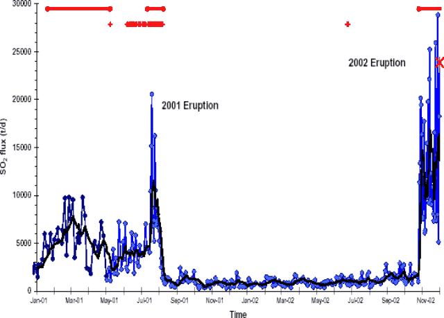 |
Figure 96. SO2 released from Etna during January 2001-1 December 2002. Courtesy INGV. |
Editor's note: Summaries of Etna activity from recent issues of the Bulletin have been prepared by our staff without the benefit of crafted summaries in English. As such, the contributors found them deficient in clarity of translation. For greater clarity and more technical details consult journal publications and the INGV website.
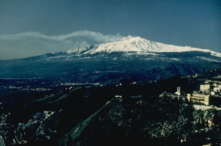
Geological Summary. Mount Etna, towering above Catania on the island of Sicily, has one of the world's longest documented records of volcanism, dating back to 1500 BCE. Historical lava flows of basaltic composition cover much of the surface of this massive volcano, whose edifice is the highest and most voluminous in Italy. The Mongibello stratovolcano, truncated by several small calderas, was constructed during the late Pleistocene and Holocene over an older shield volcano. The most prominent morphological feature of Etna is the Valle del Bove, a 5 x 10 km caldera open to the east. Two styles of eruptive activity typically occur, sometimes simultaneously. Persistent explosive eruptions, sometimes with minor lava emissions, take place from one or more summit craters. Flank vents, typically with higher effusion rates, are less frequently active and originate from fissures that open progressively downward from near the summit (usually accompanied by Strombolian eruptions at the upper end). Cinder cones are commonly constructed over the vents of lower-flank lava flows. Lava flows extend to the foot of the volcano on all sides and have reached the sea over a broad area on the SE flank.
Information Contacts: Sonia Calvari, Istituto Nazionale di Geofisica e Vulcanologia Sezione di Catania, Piazza Roma 2, 95123 Catania (URL: http://www.ct.ingv.it/).