Report on Ruang (Indonesia) — October 2002
Bulletin of the Global Volcanism Network, vol. 27, no. 10 (October 2002)
Managing Editor: Richard Wunderman.
Ruang (Indonesia) Eruption on 25 September 2002 sends ash to at least 5 km
Please cite this report as:
Global Volcanism Program, 2002. Report on Ruang (Indonesia) (Wunderman, R., ed.). Bulletin of the Global Volcanism Network, 27:10. Smithsonian Institution. https://doi.org/10.5479/si.GVP.BGVN200210-267010
Ruang
Indonesia
2.3°N, 125.37°E; summit elev. 725 m
All times are local (unless otherwise noted)
The last reported activity at Ruang occurred when Qantas Airlines pilots observed an eruption around 1600 on 27 June 1996 (BGVN 21:08). A resulting plume moved W and reached an altitude of ~6 km. However, the eruption was not visible in GMS satellite imagery. The last known confirmed eruption at Ruang occurred in 1949.
A drastic increase of seismic events - from 3 to 24 events/day - was observed on 24 September by the Volcanological Survey of Indonesia (VSI). The next day, people near the volcano reported hearing a noise, and ash eruptions began by 0100. By 0300 ash emissions were continuous, and ash began falling around Ruang island and the nearby island of Tagulandang. Observers reported that the sounds accompanying the eruption were weak. By 0400 more than 1,000 people living near the volcano were evacuated to a nearby island. Around 0800, the Alert Level advanced to the highest status (level 4).
The first strong eruption commenced at 1140 on 25 September, producing thick black clouds that rose 3 km. Ten minutes later, a second eruption sent ash clouds rising 5 km. At 1210 the activity subsided enough to observe glowing material on E flank. The specific eruption site has not been firmly established. It has been presumed by VSI that it originated from "Crater II" or "where the 1949 lava originated (E side of summit)." The eruption column was reported from ground-based observations as rising to at least 5 km, and by Darwin VAAC advisories as rising to about 17 km. According to the Darwin VAAC, satellite imagery revealed that the ash cloud drifted westward to Borneo and Sumatra. Satellite images from NOAA showed the plume drifting SW with other components drifting W (figure 1). By 30 September the volcano was quiet with only a thin white plume rising about 100 m. The Alert Level was reduced from 4 to 3 on 30 September 2002.
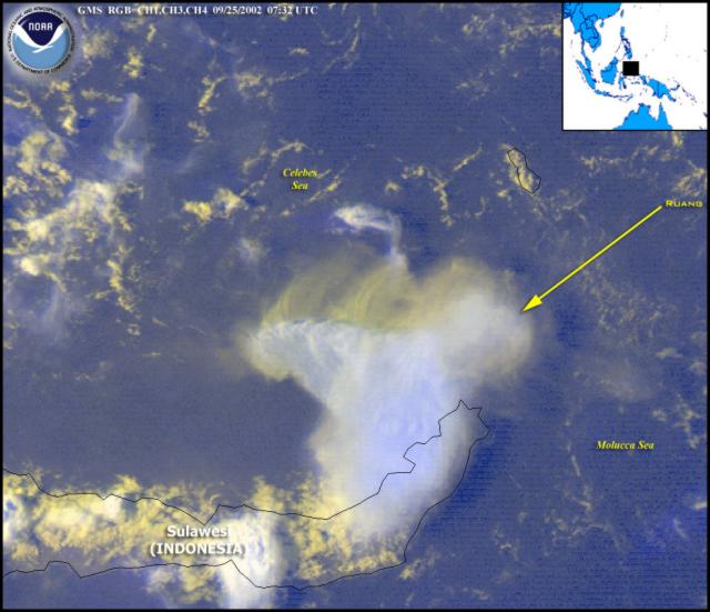 |
Figure 1. Satellite imagery on 25 September 2002 showed a large eruption plume from Ruang. The volcano's location is shown by the arrow. The plume appears to branch into SW- and W-drifting components. Courtesy NOAA. |
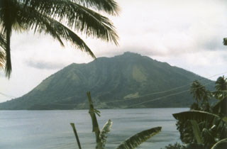
Geological Summary. Ruang volcano is the southernmost volcano in the Sangihe Island arc, north of Sulawesi Island; it is not the better known Raung volcano on Java. The 4 x 5 km island volcano is across a narrow strait SW of the larger Tagulandang Island. The summit contains a crater partially filled by a lava dome initially emplaced in 1904. Explosive eruptions recorded since 1808 have often been accompanied by lava dome formation and pyroclastic flows that have damaged inhabited areas.
Information Contacts: Volcanological Survey of Indonesia (VSI), Jalan Diponegoro No. 57, Bandung 40122, Indonesia (URL: http://www.vsi.esdm.go.id/); Darwin Volcanic Ash Advisory Center (VAAC), Bureau of Meteorology, Northern Territory Regional Office, P.O. Box 735, Darwin, NT 0801 Australia; NOAA/NESDIS Satellite Analysis Branch, Room 401, 5200 Auth Road, Camp Springs, MD 20746, USA.