Report on Niuafo'ou (Tonga) — April 2003
Bulletin of the Global Volcanism Network, vol. 28, no. 4 (April 2003)
Managing Editor: Edward Venzke.
Niuafo'ou (Tonga) Fumarolic and hot spring activity in the caldera during October 2002
Please cite this report as:
Global Volcanism Program, 2003. Report on Niuafo'ou (Tonga) (Venzke, E., ed.). Bulletin of the Global Volcanism Network, 28:4. Smithsonian Institution. https://doi.org/10.5479/si.GVP.BGVN200304-243110
Niuafo'ou
Tonga
15.6°S, 175.63°W; summit elev. 260 m
All times are local (unless otherwise noted)
Niuafo'ou is Tonga's most active volcano with at least 10 periods of activity, both explosive and effusive, since the early 1800s. The most recent period of activity in 1946 (Taylor 1999) resulted in the complete evacuation of the island. This volcanic center, ~450 km N of Tongatapu, is an isolated volcanic island located in the N-central Lau Basin (figure 4). In May 1999 a vent was producing hot water and H2S, and dead fish were observed near the vent (BGVN 26:05). Paul W. Taylor visited the volcano in October 2002 and noted fumarolic activity in two areas of the central caldera. On 20 October fumarolic and hot spring activity was noted in the NE part of the caldera.
 |
Figure 4. Locality map of the Lau Basin region, showing the location of Niuafo'ou. The symbols indicate centers with recorded eruptions (circles with stars); centers with no recorded activity (black stars); and probable submarine centers (white stars). Bathymetric contours are in kilometers. Courtesy of Paul Taylor. |
Form and structure. Niuafo'ou is a subaerial shield volcano formed by submarine explosive and effusive activity during the Holocene. The island is approximately 8 km in diameter with a central caldera ~4 km in diameter with two lakes, Vai Lahi and Vai Si'i (figures 5 and 6). Periods of explosive activity have formed several small cinder cone complexes within the caldera. A detailed description of the geological features of Niuafo'ou is provided in Taylor (1991). Niuafo'ou rises to a height of 213 m above sea level at a point on the N rim of the caldera, a point known to the Niuafo'ouans as Piu Ofahifa.
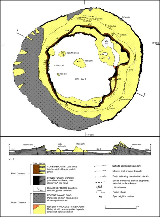 |
Figure 5. Geological map of Niuafo'ou (after Taylor, 1991) showing the major features of the island. Courtesy of Paul Taylor. |
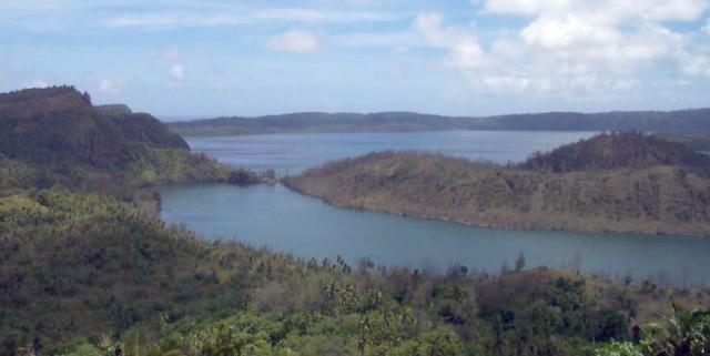 |
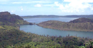
Figure 6. Photograph of Niuafo'ou looking approximately W across the caldera. Both caldera lakes, Vai Lahi (background) and Vai Si'i (foreground) are visible. Courtesy of Paul Taylor. |
Activity during October 2002. During a visit to Niuafo'ou in October 2002 to conduct a series of community workshops, it was noted that fumarolic activity was occurring in two areas of the central caldera. On 14 October Cecile Quesada (a French anthropologist) and Chris Simard visited the Vai Kona and Vai Sulfa areas along the S edge of the caldera (figure 6) and observed continued activity at the site. On 20 October, Taylor, Alejandra Meija-restrepo, Quesada, and Simard visited the Vai Si'i area in the NE part of the caldera and observed continued fumarolic and hot spring activity.
Vai Kona/Vai Sulfa Area. The Vai Kona/Vai Sulfa area of Niuafo'ou has been the site of persistent fumarolic and hot spring activity for many years. Activity was reported in 1958 (Richard, 1962) and again during 1982-83 and 1984 (Taylor, 1991). The level of Vai Kona fluctuates periodically. When Quesada and Simard visited the site on 14 October 2002, areas of persistent activity were observed.
Activity at Vai Kona was concentrated along the S shores of the lake (figure 7). Quesada and Simard observed numerous active vents on the floor of the lake, with large quantities of bubbles reaching the surface. The water temperature was estimated to be 25-30°C. Thick dark mud was present on the bottom of the lake and the temperature of the mud around the vents was estimated to be 35-40°C. Several active hot springs were also observed along the W shore of Vai Kona. These observations suggest that activity at the site has intensified since observed in 1958 and 1983.
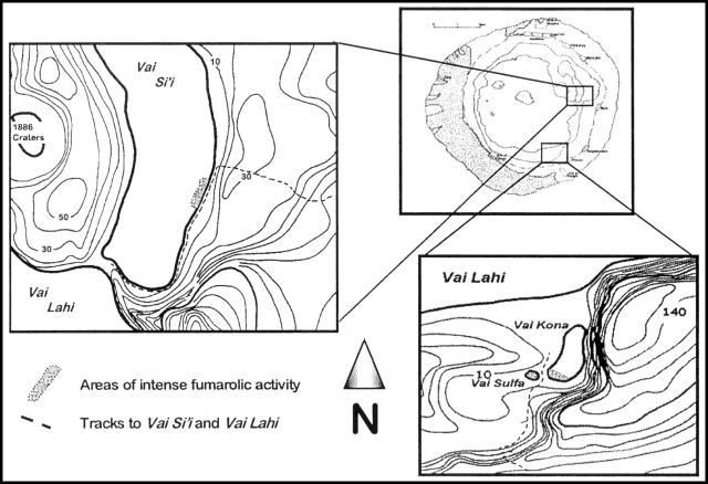 |
Figure 7. Niuafo'ou Island showing the location of fumarolic activity observed during October 2002. Courtesy of Paul Taylor. |
Vai Sulfa occupies a small depression W of the southern end of Vai Kona (figure 7). The entire feature covers an area of about 30 m2 and consists of two sections. The W part of the depression is occupied by a small lake, while the E section is dry. At the center of this dry area is a vent ~40 cm across and 20-30 cm deep filled with mud and leaves. When leaves were removed from the hole during the visit it began to fill with water, and a boiling sound was heard. Extensive deposits of sulfur existed around the entire depression, and a strong smell of sulfur was present. Similar activity was also occurring when Quesada and Simard visited the area during July and September 2001. However, activity was less intense at those times.
Vai Si'i Area. A new site of fumarolic activity was first reported during May 1999 and observed during June 1999 (BGVN 26:05). When the site was visited on 20 October the focus of activity had moved to an area along the E shore of Vai Si'i. Numerous vents were present on the floor of the lake along the shoreline. The affected area stretched along the shoreline for ~25-30 m from where the vents were concentrated (figure 7). Active vents were aligned along the shoreline. Although the temperature of the lake water was an estimated 30°C (the prevailing air temperature), the temperature just below the surface of the sediment around the vents had increased to an estimated 65-75°C.
The vents were producing gas that was bubbling to the surface. A strong sulfur smell was noted, and large deposits of sulfur were present in the mud that comprised the floor of the lake around the vents. The deposits formed three elongated lobes that stretched S from the vents. The lobe-like distribution was probably the result of wind-induced currents. Vegetation along the shoreline was dead and encrusted with white sulfur (?). The observations suggests a net increase in activity at the Vai Si'i site since June 1999.
Conclusions. The observed fumarolic activity on Niuafo'ou indicates that the volcanic system is still active. Although not widespread, the fumarolic manifestations observed during 1999-2002 probably represent a net increase in the activity of the system since the last eruption in 1946. At this stage the level of activity is not of concern, but it should be monitored for signs of increase.
References. Richard, J.J., 1962, Kermadec, Tonga and Samoa: Catalogue of Active Volcanoes of the World, part 13.
Taylor, P.W., 1991, The Geology and Petrology of Niuafo'ou Island, Tonga: Subaerial Volcanism in an Active Back-arc Basin: Unpublished MSc thesis, Macquarie University, AVI Occasional Report, No. 91/01.
Taylor, P.W., 1999, The 1946 Eruption of Niuafo'ou: AVI Occasional Report, No. 99/03.
Geological Summary. Niuafo'ou ("Tin Can Island") is a low 8-km-wide island that forms the summit of a largely submerged basaltic shield volcano in the north central Lau Basin about 170 km W of the northern end of the Tofua volcanic arc. The circular island encloses a 5-km-wide caldera that is mostly filled by a lake whose bottom extends to below sea level. The inner walls of the caldera drop sharply to the lake, named Big Lake (or Vai Lahi), which contains several small islands and pyroclastic cones on its NE shore. Eruptions recorded since 1814, mostly from circumferential fissures on the west-to-south side of the island, have often damaged villages. A major eruption in 1946 forced evacuation of most of its 1,200 inhabitants.
Information Contacts: Paul W. Taylor, Australian Volcanological Investigations, PO Box 291, Pymble, NSW 2073 Australia.