Report on Chikurachki (Russia) — May 2003
Bulletin of the Global Volcanism Network, vol. 28, no. 5 (May 2003)
Managing Editor: Edward Venzke.
Chikurachki (Russia) Eruption continued through May; long plumes and some ashfall
Please cite this report as:
Global Volcanism Program, 2003. Report on Chikurachki (Russia) (Venzke, E., ed.). Bulletin of the Global Volcanism Network, 28:5. Smithsonian Institution. https://doi.org/10.5479/si.GVP.BGVN200305-290360
Chikurachki
Russia
50.324°N, 155.461°E; summit elev. 1781 m
All times are local (unless otherwise noted)
The eruption that began on 18 April 2003 (BGVN 28:04) continued throughout May and into early June. According to observers, ash fell on the town of Severo-Kurilsk (~60 km from the volcano) on 1 May. Observers from Vasiliev Cape noted weak fumarolic activity on 3 May and satellite data from the USA and Russia that day revealed a gas-and-steam plume more than 150 km long and moving towards the ESE and S. Satellite data continued to show gas-and-steam plumes, possibly containing ash, throughout the remainder of May (table 1). Satellite imaging was obscured by clouds on other days. On 13 May, ash deposits were reported on the ENE and SSE flanks of the volcano and near the summit. At 1800 on 15 May, observers on Paramushir Island reported a strong ashfall at Podgorny settlement.
Table 1. Satellite data reports of gas-and-steam and ash plumes emanating from Chikurachki, May 2003. Courtesy of KVERT.
| Date | Time (UTC) | Estimated Plume Length (km) | Direction |
| 05 May 2003 | -- | 50 | NW |
| 07/08 May 2003 | -- | 150 | E-SE |
| 12 May 2003 | 0019 | 20 | SE |
| 12 May 2003 | 0449 | 156 | E |
| 13 May 2003 | 0043 | 100 | E |
| 13 May 2003 | 0102 | 70 | SE |
| 13 May 2003 | 0200 | 50 | E |
| 13 May 2003 | 0423 | 178 | E-SE |
| 13 May 2003 | 0639 | 400 | E-SE |
| 17 May 2003 | -- | 50 | SW |
| 18 May 2003 | -- | 50 | NE |
| 21 May 2003 | -- | 10 | NW |
| 27 May 2003 | 0600 | 100 | NE |
| 27 May 2003 | 2200 | 100 | NE |
| 29 May 2003 | AM | 15-20 | NE |
During the period 1930 to 2310 on 27 May, Leonid Kotenko on Paramushir Island reported that ash explosions attaining heights of 500 m above the crater were observed from Shelekhov Bay. The ash plume at 0900 on 28 May (2200 UTC, 27 May), rose 4,000 m above the crater. On 29 May an ash plume rose ~1,200 m above the crater and ash fell on the town of Severo-Kurilsk.
Additional information about the 2002 eruption. Previous KVERT reports indicated that the eruption that began on 25 January 2002 had continued through 16 March (BGVN 27:04), but no further reports were made about that activity. However, later information was received that showed the eruption continuing through at least 22 April. According to satellite data from AVO for 18 March, two consecutive GMS infrared images (1732 and 1832 UTC) showed a narrow, ~150-km-long cloud, which extended SE from Paramushir Island. There was no indication of ash based on the split-window technique. On the afternoon of 20 March, a gas-and-steam plume with some ash extended 200 km SE. Paramushir Island was obscured by clouds during the next 2 weeks. On 6 May L. Kotenko (A KVERT contact on the island) reported that hunters had observed fresh ash deposits on the SW flank on 22 April and that ashfall was also noted in Severo-Kurilsk.
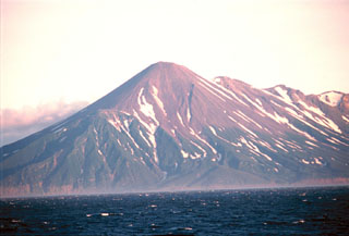
Geological Summary. Chikurachki, the highest volcano on Paramushir Island in the northern Kuriles, is a relatively small cone constructed on a high Pleistocene edifice. Oxidized basaltic-to-andesitic scoria deposits covering the upper part of the young cone give it a distinctive red color. Frequent basaltic Plinian eruptions have occurred during the Holocene. Lava flows have reached the sea and formed capes on the NW coast; several young lava flows are also present on the E flank beneath a scoria deposit. The Tatarinov group of six volcanic centers is located immediately to the south, and the Lomonosov cinder cone group, the source of an early Holocene lava flow that reached the saddle between it and Fuss Peak to the west, lies at the southern end of the N-S-trending Chikurachki-Tatarinov complex. In contrast to the frequently active Chikurachki, the Tatarinov centers are extensively modified by erosion and have a more complex structure. Tephrochronology gives evidence of an eruption around 1690 CE from Tatarinov, although its southern cone contains a sulfur-encrusted crater with fumaroles that were active along the margin of a crater lake until 1959.
Information Contacts: Olga Girina, Kamchatka Volcanic Eruptions Response Team (KVERT), a cooperative program of the Institute of Volcanic Geology and Geochemistry, Far East Division, Russian Academy of Sciences, Piip Ave. 9, Petropavlovsk-Kamchatsky, 683006, Russia, the Kamchatka Experimental and Methodical Seismological Department (KEMSD), GS RAS (Russia), and the Alaska Volcano Observatory (USA); Alaska Volcano Observatory (AVO), a cooperative program of a) U.S. Geological Survey, 4200 University Drive, Anchorage, AK 99508-4667, USA (URL: http://www.avo.alaska.edu/), b) Geophysical Institute, University of Alaska, PO Box 757320, Fairbanks, AK 99775-7320, USA, and c) Alaska Division of Geological and Geophysical Surveys, 794 University Ave., Suite 200, Fairbanks, AK 99709, USA.