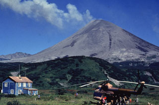
Report on Karymsky (Russia) — May 2003
Bulletin of the Global Volcanism Network, vol. 28, no. 5 (May 2003)
Managing Editor: Edward Venzke.
Karymsky (Russia) Frequent ash plumes generated from October 2002 through May 2003
Please cite this report as:
Global Volcanism Program, 2003. Report on Karymsky (Russia) (Venzke, E., ed.). Bulletin of the Global Volcanism Network, 28:5. Smithsonian Institution. https://doi.org/10.5479/si.GVP.BGVN200305-300130
Karymsky
Russia
54.049°N, 159.443°E; summit elev. 1513 m
All times are local (unless otherwise noted)
According to the Kamchatka Volcanic Eruptions Response Team (KVERT), the alert level Color Code remained at Yellow (volcano is restless; eruption may occur) from October 2002 to 27 February 2003, when it was dropped to Green (volcano is dormant; normal seismicity and fumarolic activity). The level was raised again to Yellow in March, lowered to Green on 29 March, and raised to Yellow on 18 April, where it remained through May. Seismicity was above background levels until 20 February, after which it fluctuated between at and above background levels until 16 May, when seismicity remained above background levels. All times are local (= UTC + 11 hours, + 12 hours after 26 October).
Activity during October 2002. From 4 to 31 October, ~200-250 local shallow seismic events occurred per day. The character of the seismicity indicated ash-and-gas explosions to heights of 1,000 m above the volcano (~2,500 m altitude) and gas blow-outs. A faint 10-km-long plume extending SSE was visible in an AVHRR satellite image; no ash was detected. Seismicity on 25-26 October indicated possible vigorous gas emissions lasting 5-10 minutes, with the probability of a lava flow. At 1350 on 31 October, pilots reported that an ash plume rose 4 km and extended SE. According to seismic data from the Kamchatka Experimental and Methodical Seismological Department (KEMSD), the character of seismicity after 1400 on 31 October indicated a moving lava flow. At 1314 on 31 October, the MODIS satellite image showed a large bright thermal anomaly at the volcano and a plume ~60 km long that extended WSW. At 1100 on 1 November, pilots reported that an ash plume rose 4 km and extended SE.
Activity during November 2002. Local shallow seismic events totaled ~200-250 each day. The character of the seismicity indicated ash-and-gas explosions to heights of 1,000-2,000 m above the volcano and vigorous gas emissions lasting 5-10 minutes. At 1605 on 1 November, a 50-km-long plume was observed extending E in satellite imagery; no ash was detected. According to data from KEMSD, at 2357 on 20 November, a seismic event lasting 20 minutes indicated that ash explosions to heights of 1,000 m above the crater and hot avalanches possibly occurred. On 27 November, a >100-km gas-and-steam plume extending ESE from the crater of the volcano was observed in MODIS satellite imagery. Helicopter observations by KVERT scientists at 1151 on 1 December identified an ash plume to ~500 m above the crater extending SE.
Activity during December 2002. Local shallow seismic events totaled ~190-230 each day. The character of seismicity indicated that ash-gas explosions to heights of 1,000 m above the volcano (~2,500 m altitude) and vigorous gas emissions lasting 5-10 minutes were possibly occurring. The top of the volcano and its SE flank were covered with recent ashfall and debris from continuing Vulcanian / Strombolian eruptions. The old crater was covered by the new cinder-ash cone. On 12 December, two sectors of ash falls extending S and SE from the volcano were noted in a MODIS satellite image.
Activity during January 2003. Local shallow seismic events totaled ~110-200 each day. The character of seismicity indicated that ash-gas explosions to heights of 1,000 m above the volcano (~2,500 m or 8,200 ft. ASL) and vigorous gas emissions lasting 5-10 minutes were possibly occurring. From 1559 until 1609 on 8 January, a series of shallow events that possibly indicated hot avalanches were registered. On 9 January, a ~50-km plume extending ESE from the volcano was noted.
Activity during February 2003. The alert level Color Code remained at Yellow until 27 February, when it was lowered to Green (volcano is dormant; normal seismicity and fumarolic activity). According to satellite data from Russia, a weak thermal anomaly was noted on 3 February. Seismic activity was at background levels on 20-23 February.
Activity during March 2003. The alert level Color Code was raised to Yellow as the activity of the volcano slightly increased. Seismic activity was at background levels on 13-18 March and slightly above background levels on 19 March when seismic data indicated possible hot avalanches. Weak volcanic earthquakes were also registered on this day. According to MODIS-satellite data from Russia and the USA, ash deposits extending more than 30 km SW from the volcano on 17-20 March and gas-steam plumes drifting more than 15 km NW and SW on 18 March and on 20 March, respectively, were noted. Seismic activity dropped to background levels for the week of 20 March. According to satellite data from Russia, a weak thermal anomaly was observed on 25 March, and a gas-and-steam plume extending 10 km ESE was noted on 28 March. According to helicopter observations on 31 March by the Institute of Volcanology (IV), Far East Division, Russian Academy of Sciences, the large old active crater of the volcano and its black ESE flank were noted, but the new cinder-ash cone was not seen. This cone was probably destroyed and its products formed ash-deposits extending >35 km ESE, which were noted on the 17-18 March MODIS-satellite images.
Activity during April 2003. The alert level Color Code was dropped to Green during the week of 29 March-4 April, when seismic activity was at background levels. Seismicity rose above background levels during the week of 18-24 April, when ~40-100 volcanic earthquakes per day were recorded, and the hazard status was raised to Yellow. The character of the seismicity indicated ash-and-gas explosions up to 1,000 m above the crater. According to satellite data from Russia, ash deposits up to 35 km or longer extended in different directions on 19-22 April. According to observers from IV, on 18-24 April occasional ash-gas explosions up to 2,500 m above the crater occurred each day, and on 21 April, an ash-gas plume rose 1,500 m. Seismic activity was above background levels on 24-27 April and at background levels on 27-30 April. During 24-26 April 50-100 volcanic earthquakes per day were registered. The character of the seismicity indicated that three eruption events (possibly ash-and-gas explosions and rock avalanches) occurred on 24 April. According to satellite data from Russia, wide ash deposits longer than 35 km and three narrow ash deposits less than 5 km long extending SE and W and SW from the volcano, respectively, were noted on 25 April and 28-29 April. According to observers from IV FED RAS, on 24 April, an ash-gas plume rose 2,500 m above the crater.
Activity during May 2003. The alert level Color Code remained at Yellow for the month, with intermittent explosive eruptions continuing. Occasional explosions up to 1,500 m above the volcano, producing ash, were considered to be possible, as well as ashfall within a few tens of kilometers. Seismic activity was at background levels during 3-16 May. According to satellite data from Russia, the summit of the volcano was black on 4 May. For the week of 10-16 May, seismic data indicated that 10 ash-and-gas explosions reached heights up to 1,000 m above the crater, and hot avalanches possibly occurred. According to satellite data from the USA and Russia, a weak 1-pixel thermal anomaly on 14 May, and strips of ash deposits extending >10 km to the S, SSE and SE on 14-15 May were noted. Seismicity was above background levels on 16-30 May.
During 18-21 May, 150-320 local shallow events occurred per day. The character of the seismicity indicated ash-and-gas explosions to heights of 1,000 m above the volcano, gas blow-outs and hot avalanches. According to satellite data from the USA and Russia, a 2-4-pixel thermal anomaly was observed during 18-22 May. Ash deposits on snow E and SE of the volcano were noted on 18 May. Gas-steam plumes extending up to 45 km NE and N of the volcano on 19 and 21 May were noted. For the week of 24-30 May, 280-330 local shallow seismic events occurred per day. The character of the seismicity indicated ash-and-gas explosions to heights of 1,000 m and gas blow-outs. A thermal anomaly continued to be observed. On 25-26 May, gas-and-steam plumes extending 15-115 km SSE from the volcano were noted. Ash deposits on the snow in a different direction from the volcano were noted on 26-27 May.
Geological Summary. Karymsky, the most active volcano of Kamchatka's eastern volcanic zone, is a symmetrical stratovolcano constructed within a 5-km-wide caldera that formed during the early Holocene. The caldera cuts the south side of the Pleistocene Dvor volcano and is located outside the north margin of the large mid-Pleistocene Polovinka caldera, which contains the smaller Akademia Nauk and Odnoboky calderas. Most seismicity preceding Karymsky eruptions originated beneath Akademia Nauk caldera, located immediately south. The caldera enclosing Karymsky formed about 7600-7700 radiocarbon years ago; construction of the stratovolcano began about 2000 years later. The latest eruptive period began about 500 years ago, following a 2300-year quiescence. Much of the cone is mantled by lava flows less than 200 years old. Historical eruptions have been vulcanian or vulcanian-strombolian with moderate explosive activity and occasional lava flows from the summit crater.
Information Contacts: Olga Girina, Kamchatka Volcanic Eruptions Response Team (KVERT), a cooperative program of the Institute of Volcanic Geology and Geochemistry, Far East Division, Russian Academy of Sciences, Piip Ave. 9, Petropavlovsk-Kamchatsky, 683006, Russia, the Kamchatka Experimental and Methodical Seismological Department (KEMSD), GS RAS (Russia), and the Alaska Volcano Observatory (USA); Alaska Volcano Observatory (AVO), a cooperative program of a) U.S. Geological Survey, 4200 University Drive, Anchorage, AK 99508-4667, USA (URL: http://www.avo.alaska.edu/), b) Geophysical Institute, University of Alaska, PO Box 757320, Fairbanks, AK 99775-7320, USA, and c) Alaska Division of Geological and Geophysical Surveys, 794 University Ave., Suite 200, Fairbanks, AK 99709, USA.