Report on Anatahan (United States) — June 2003

Bulletin of the Global Volcanism Network, vol. 28, no. 6 (June 2003)
Managing Editor: Edward Venzke.
Anatahan (United States) Small lava dome in inner crater destroyed by explosion; activity declines
Please cite this report as:
Global Volcanism Program, 2003. Report on Anatahan (United States) (Venzke, E., ed.). Bulletin of the Global Volcanism Network, 28:6. Smithsonian Institution. https://doi.org/10.5479/si.GVP.BGVN200306-284200
Anatahan
United States
16.35°N, 145.67°E; summit elev. 790 m
All times are local (unless otherwise noted)
The first historical eruption of the small volcanic island Anatahan began at about 1700 on 10 May 2003 (BGVN 28:04). The island is in the Commonwealth of the Northern Mariana Islands (CNMI) and has been uninhabited since it was evacuated on 29 May 1993 as the result of an earthquake swarm (BGVN 18:05 and 18:08). Shortly after the eruption began, the Emergency Management Office (EMO) of CNMI invited U.S. Geological Survey (USGS) scientists to provide assistance in tracking the volcano's activity and assessing potential hazards. This report discusses a seismically detected phreatic stage during 10-20 May followed by a new lava discharge on 4 June. After mid-July seismicity and volcanism declined.
Records from a broadband seismograph installed by Washington University 6.5 km W of the Anatahan crater on 6 May 2003 were retrieved on 20 May. F.A. Trusdell and R. White (USGS) reviewed the records and plotted estimate of the numbers of volcano-tectonic (VT) events and their maximum magnitudes, and an estimate of the background and/or tremor level for 9-11 May 2003 (figure 8). No VT events or tremor appeared during 6-9 May. Unrecorded precursory activity may have occurred prior to the seismograph installation. Trusdell and White described their findings as follows in their report of 5 June 2003.
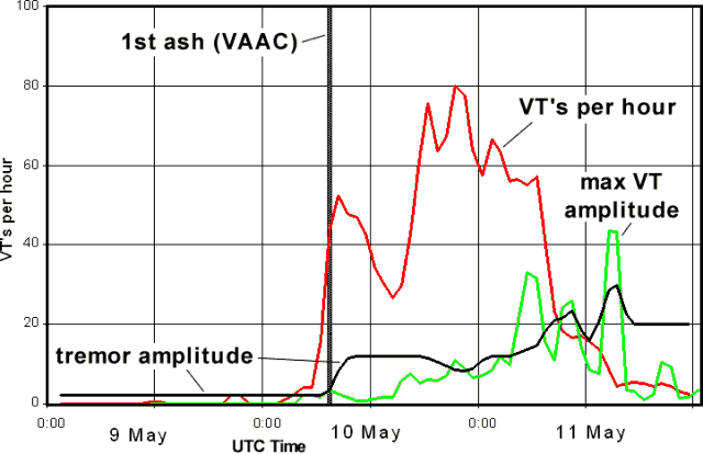 |
Figure 8. Plot of several seismic parameters at Anatahan, 9-11 May 2003. Estimates of numbers of VT events/hour (left-side scale) and their maximum magnitudes (arbitrary scale), and the tremor magnitudes (arbitrary scale). Courtesy of F.A. Trusdell, USGS. |
"Beginning on May 10, the number of hourly events increases from 0-1 the first couple of hours to 20-33 by [1400 and 1500 hours local time]—then surges to more than 100 events/hr beginning at [1600]. These events are all VTs, with impulsive P and S phases that decay rapidly. The largest events didn't exceed about M 2 on May 10. The spectra are broadband with dominant frequencies between 8 and 10 Hz, the higher frequencies probably attenuated by the 6.5 km travel path (the distance between the crater and the Washington University seismograph). Note that late on the 10th, the number of events begins to decrease rapidly and about this same time, the amplitude of the largest events increases rapidly. The largest VT of all (through the last record available, of May 20) had a magnitude of about M 3.1 and occurred a little after noon on the 11th. After that event, both the numbers and amplitudes of the VTs dropped off rapidly (and remained very low through the last record available, on May 20.
"The background noise level remained very low until [1700] on May 10, when the level increased by 2.5x and by [1800] the tremor level was ~6x above the background level. We infer that the rising tremor level corresponds to the approximate onset of gas and ash emission into the atmosphere. The [Washington VAAC (Volcanic Ash Advisory Center)] estimates that the ash first appeared about [1730]. The tremor level increased further and peaked on May 11.
"Notes on May 11-20: The tremor level remained very high for a couple of days before decreasing by about half (10 arbitrary units on the figure) by May 20. By about May 15, unambiguous LP's [(long-period events)] begin to appear. By May 19 and 20, there appear brief moments (several seconds) when the tremor level drops to near background immediately prior to the largest LP's which often contain air phases. Even the largest LP's are not particularly large, maybe M 2-2.5. All of this activity from May 10-20 is compatible with an aggressive phreatic stage."
The spiny surface of a lava flow was first observed in the inner crater on 4 June. The flow appeared to form a mound-shaped lava dome, but its volume is unknown. Scientists also noted the presence of new fault scarps and slump features within the E crater, as well as additional faulting to its W. Such features commonly develop around active vents due to the rise and subsequent eruption of magma. On 5 June the EMO seismic station was repaired and ash samples were collected from the site. Through 12 June, the seismic records showed only continuous ground shaking (tremor) to varying degrees. The most intense periods of tremor lasted 3-10 hours and occurred about every 24-36 hours. On 12 June, three LP earthquakes were recorded, the largest about M 2. Other earthquakes followed on the late afternoon and early evening of 13 June.
Two strong explosions on 14 June removed much of the small new dome in the inner crater. Just before noon on that day, earthquakes began to occur every 1-2 minutes. For the next two days, several episodes of intense tremor and earthquakes lasting ~1.5 hours occurred about every 12 hours. These episodes of increased seismic activity accompanied strong ash emissions from the E crater, with eruption columns higher than 2 km. Quiet intervals in which the eruption column consisted of little ash were accompanied by continuous low tremor. At 1613 on 16 June observers noticed that the light-colored, steam-dominated, eruption cloud got darker and rose very quickly (20-40 seconds) to ~2.5 km altitude (figure 9). At this time, the seismic amplitude went from "small" to "large" (a 5-10x increase). Since 16 June seismic activity has consisted only of low-level tremor, and even that low level was gradually shrinking.
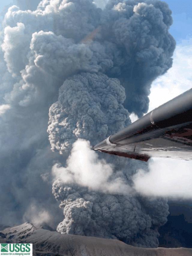 |
Figure 9. Ash cloud rising from Anatahan on 16 June 2003. Courtesy USGS Hawaiian Volcano Observatory. |
As of 9 July the eruption continued to wane, as shown by decreasing amplitudes of volcanic tremor. Observations from a helicopter on that day revealed only white steam low in the E crater and a minor amount of light brown fume without ash emission.
Geological Summary. The elongate, 9-km-long island of Anatahan in the central Mariana Islands consists of a large stratovolcano with a 2.3 x 5 km compound summit caldera. The larger western portion of the caldera is 2.3 x 3 km wide, and its western rim forms the island's high point. Ponded lava flows overlain by pyroclastic deposits fill the floor of the western caldera, whose SW side is cut by a fresh-looking smaller crater. The 2-km-wide eastern portion of the caldera contained a steep-walled inner crater whose floor prior to the 2003 eruption was only 68 m above sea level. A submarine cone, named NE Anatahan, rises to within 460 m of the sea surface on the NE flank, and numerous other submarine vents are found on the NE-to-SE flanks. Sparseness of vegetation on the most recent lava flows had indicated that they were of Holocene age, but the first historical eruption did not occur until May 2003, when a large explosive eruption took place forming a new crater inside the eastern caldera.
Information Contacts: Juan Takai Camacho and Ramon Chong, Commonwealth of the Northern Mariana Islands Emergency Management Office, P.O. Box 10007, Saipan, MP 96950 USA (URL: http://www.cnmihsem.gov.mp/); Frank Trusdell, U.S. Geological Survey, Hawaiian Volcano Observatory (HVO), PO Box 51, Hawaii National Park, HI 96718, USA (URL: https://volcanoes.usgs.gov/nmi/activity/); Randal A. White, U.S. Geological Survey, 345 Middlefield Road, MS 910, Menlo Park, CA 94025 USA.