Report on Gamalama (Indonesia) — July 2003
Bulletin of the Global Volcanism Network, vol. 28, no. 7 (July 2003)
Managing Editor: Edward Venzke.
Gamalama (Indonesia) Ashfall from 31 July eruption coats Ternate; pyroclastic flow
Please cite this report as:
Global Volcanism Program, 2003. Report on Gamalama (Indonesia) (Venzke, E., ed.). Bulletin of the Global Volcanism Network, 28:7. Smithsonian Institution. https://doi.org/10.5479/si.GVP.BGVN200307-268060
Gamalama
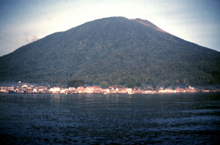
Indonesia
0.81°N, 127.3322°E; summit elev. 1714 m
All times are local (unless otherwise noted)
According to the Volcanological Survey of Indonesia (VSI), at 0300 on 31 July 2003, six type-A volcanic earthquakes were recorded. At 0600 the cloud issuing from the crater became thicker, but the gas pressure remained modest and similar to that normally seen. A series of explosive eruptions that began at 1434 sent a dark gray ash column 500-1,000 m high that drifted E toward Sultan Baabulah airport. A second explosion at 1625 produced a dark-gray ash column with strong gas pressure. The ash column rose 1-2 km above rim and drifted E carrying glowing material.
At 1627 a pyroclastic flow into Togorar valley on the NE flank traveled as much as 1 km but did not reach the village. A continuous blasting sound accompanied a series of ash emissions. Between 1704-1812, a dark gray ash column rose to 1,000-1,500 m, then during 1850-2200 a white-gray ash plume rose to 500 m. Several white gas plumes rose 10-150 m from 2209 through 0600 on 1 August. A steady glow was observed from 0200-0400.
After the initial outbursts, during 0000-1430 on 1 August, seismometers registered seven tectonic earthquakes, 16 shallow volcanic earthquakes, and two deep volcanic earthquakes. Continuous tremor also registered, with a maximum amplitude of 29-30 mm. Ashfall was 1-3 cm thick in the E part of the area, and some of the local population was evacuated.
According to local officials, Ternate (the regional capital, ~7 km E of Gamalama) was covered with thick ash. There were no reports of casualties or damage. The hazard status was set at level 3 starting at 1250 on 31 July and raised to the maximum, level 4, at 0000 the next day.
VSI reported that the last eruption occurred in 1996 from the main crater, followed by a pyroclastic flow to the E.
Geological Summary. Gamalama is a near-conical stratovolcano that comprises the entire island of Ternate off the western coast of Halmahera, and is one of Indonesia's most active volcanoes. The island was a major regional center in the Portuguese and Dutch spice trade for several centuries, which contributed to the extensive documentation of activity. Three cones, progressively younger to the north, form the summit. Several maars and vents define a rift zone, parallel to the Halmahera island arc, that cuts the volcano; the S-flank Ngade maar formed after about 14,500–13,000 cal. BP (Faral et al., 2022). Eruptions, recorded frequently since the 16th century, typically originated from the summit craters, although flank eruptions have occurred in 1763, 1770, 1775, and 1962-63.
Information Contacts: Dali Ahmad, Volcanological Survey of Indonesia (VSI), Jalan Diponegoro No. 57, Bandung 40122, Indonesia (URL: http://www.vsi.esdm.go.id/).