Report on Yellowstone (United States) — July 2003
Bulletin of the Global Volcanism Network, vol. 28, no. 7 (July 2003)
Managing Editor: Edward Venzke.
Yellowstone (United States) Geyser basin heats up, affecting thermal features
Please cite this report as:
Global Volcanism Program, 2003. Report on Yellowstone (United States) (Venzke, E., ed.). Bulletin of the Global Volcanism Network, 28:7. Smithsonian Institution. https://doi.org/10.5479/si.GVP.BGVN200307-325010
Yellowstone
United States
44.43°N, 110.67°W; summit elev. 2805 m
All times are local (unless otherwise noted)
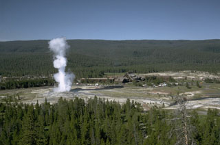
Yellowstone National Park press releases indicated unusual hydrothermal activity at the Norris geyser basin in the NW-central portion of the Park. A press release on 22 July 2003 announced that high ground temperatures and increased thermal activity had resulted in the temporary closure of a portion of the Back Basin.
The press release noted "Norris is the hottest and most seismically active geyser basin in Yellowstone. Recent activity in the Norris geyser basin has included formation of new mud pots, an eruption of Porkchop geyser (dormant since 1989), the draining of several geysers, creating steam vents and significantly increased measured ground temperatures (up to 200°F [93°C]). Additional observations include vegetation dying due to thermal activity and the changing of several geysers' eruption intervals. Vixen geyser has become more frequent and Echinus geyser has become more regular."
A press release on 7 August advised of a hydrothermal monitoring program by the Yellowstone Volcano Observatory to begin at Norris geyser basin. The Observatory is a collaborative partnership between the US Geological Survey, the University of Utah, and Yellowstone National Park. It was deploying a temporary network of seismographs, Global Positioning System receivers, and temperature loggers. Goals included identification of hydrothermal steam sources, the relationship of the behavior of Norris geyser basin to the general seismicity, and locating crustal deformation in the caldera.
Geological Summary. The Yellowstone Plateau volcanic field developed through three volcanic cycles spanning two million years that included some of the world's largest known eruptions. Eruption of the over 2,450 km3 Huckleberry Ridge Tuff about 2.1 million years ago created the more than 75-km-long Island Park caldera. The second cycle concluded with the eruption of the Mesa Falls Tuff around 1.3 million years ago, forming the 16-km-wide Henrys Fork caldera at the western end of the first caldera. Activity subsequently shifted to the present Yellowstone Plateau and culminated 640,000 years ago with the eruption of the over 1,000 km3 Lava Creek Tuff and the formation of the present 45 x 85 km caldera. Resurgent doming subsequently occurred at both the NE and SW sides of the caldera and voluminous (1000 km3) intracaldera rhyolitic lava flows were erupted between 150,000 and 70,000 years ago. No magmatic eruptions have occurred since the late Pleistocene, but large hydrothermal events took place near Yellowstone Lake during the Holocene. Yellowstone is presently the site of one of the world's largest hydrothermal systems, including Earth's largest concentration of geysers.
Information Contacts: Yellowstone Volcano Observatory, a cooperative arrangement that includesRobert L. Christiansen, U.S. Geological Survey, 345 Middlefield Road, Menlo Park, CA 94025; Robert B. Smith, Department of Geology and Geophysics, University of Utah, Salt Lake City, Utah 84112 USA; Henry Heasler, National Park Service, P.O. Box 168, Yellowstone National Park, WY 82190-0168 USA; and others (URL: https://volcanoes.usgs.gov/observatories/yvo/).