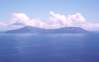
Report on Anatahan (United States) — September 2003
Bulletin of the Global Volcanism Network, vol. 28, no. 9 (September 2003)
Managing Editor: Edward Venzke.
Anatahan (United States) Very low seismicity with no ash emissions; geothermal activity in the crater
Please cite this report as:
Global Volcanism Program, 2003. Report on Anatahan (United States) (Venzke, E., ed.). Bulletin of the Global Volcanism Network, 28:9. Smithsonian Institution. https://doi.org/10.5479/si.GVP.BGVN200309-284200
Anatahan
United States
16.35°N, 145.67°E; summit elev. 790 m
All times are local (unless otherwise noted)
The first recorded historical eruption at Anatahan, which began on 10 May 2003, continued through that month with nearly continuous ash plumes (BGVN 28:04 and 28:05). Two strong explosions on 14 June removed much of a small lava dome that had been extruded in the crater; dark ash plumes were last reported on 16 June, after which time seismicity decreased significantly (BGVN 28:06). Only steaming without ash emissions was reported by scientists doing fieldwork immediately afterwards (BGVN 28:07) and on overflights in July. Volcanic tremor and other seismicity reported by the Commonwealth of the Northern Mariana Islands (CNMI) Emergency Management Office (EMO) persisted into early August at a relatively low level. This report covers observed activity from 4 August to 5 October 2003.
Seismicity was low throughout the report period and no apparent eruption signals or potential precursory events occurred. Tremor and seismic energy release were at low levels. During 2-6 August, small long-period (LP) events occurred regularly. At the end of that interval, the number of small LP events increased to several hundred in 24 hours, compared to a couple dozen per day earlier in the swarm, but the overall energy release increase was not significant. No LP events were reported again until mid-September. On 5 September, tremor and seismic energy release were reported to be at their lowest levels since early July.
Overflights of the volcano were made by USGS and EMO personnel on 30 August and 8, 9, and 11 September. Observations on these days revealed no ash emissions, and the feeble plume was dominated by steam and lesser amounts of volcanic gases, mainly SO2. Sporadic emissions sometimes rose above the crater rim. The E crater floor was covered by dirty, sediment-laden, steaming water, and an active geothermal system had mud pots, mini-geysers, and steam jets. Steaming water and sulfurous gases were emitted from the crater walls and floor. Observations during an 18 September overflight were similar to those earlier in the month, although the crater floor appeared to be covered by muddy water instead of a shallow lake. A distinct odor of SO2 and blue fume were noted during a helicopter inspection of the E crater lake on 27 September. On 29 September, geysering was seen and the odor of H2S was present in addition to SO2.
By 12 September USGS and EMO had reestablished the original, pre-eruption Anatahan seismic station (ANAT) on the SW caldera rim. On 15 September, several, small-amplitude, LP events lasting up to 15 seconds were visible on the ANAT records with dominant frequencies of 4-5 Hz. Some of the larger events had a short burst of 6-7 Hz energy about 2.5 seconds after the onset. The largest events were barely above background at the E Anatahan station (ANA2) and may have been occurring undetected for the past several weeks. The LP events at the ANAT station continued over the next two days at a rate of several per hour.
Geological Summary. The elongate, 9-km-long island of Anatahan in the central Mariana Islands consists of a large stratovolcano with a 2.3 x 5 km compound summit caldera. The larger western portion of the caldera is 2.3 x 3 km wide, and its western rim forms the island's high point. Ponded lava flows overlain by pyroclastic deposits fill the floor of the western caldera, whose SW side is cut by a fresh-looking smaller crater. The 2-km-wide eastern portion of the caldera contained a steep-walled inner crater whose floor prior to the 2003 eruption was only 68 m above sea level. A submarine cone, named NE Anatahan, rises to within 460 m of the sea surface on the NE flank, and numerous other submarine vents are found on the NE-to-SE flanks. Sparseness of vegetation on the most recent lava flows had indicated that they were of Holocene age, but the first historical eruption did not occur until May 2003, when a large explosive eruption took place forming a new crater inside the eastern caldera.
Information Contacts: Juan Takai Camacho and Ramon Chong, Commonwealth of the Northern Mariana Islands Emergency Management Office, P.O. Box 10007, Saipan, MP 96950 USA (URL: http://www.cnmihsem.gov.mp/); Frank Trusdell, U.S. Geological Survey, Hawaiian Volcano Observatory (HVO), PO Box 51, Hawaii National Park, HI 96718, USA (URL: https://volcanoes.usgs.gov/nmi/activity/).

