Report on NW Rota-1 (United States) — March 2004
Bulletin of the Global Volcanism Network, vol. 29, no. 3 (March 2004)
Managing Editor: Richard Wunderman.
NW Rota-1 (United States) Minor submarine eruption seen at depth; quiet at West Rota caldera
Please cite this report as:
Global Volcanism Program, 2004. Report on NW Rota-1 (United States) (Wunderman, R., ed.). Bulletin of the Global Volcanism Network, 29:3. Smithsonian Institution. https://doi.org/10.5479/si.GVP.BGVN200403-284211
NW Rota-1
United States
14.601°N, 144.775°E; summit elev. -517 m
All times are local (unless otherwise noted)
The research vessel Thomas G. Thompson conducted a survey of the Mariana Arc in the Commonwealth of the Northern Mariana Islands from 9 February to 5 March 2003 (Embley and others, 2004). That survey identified a number of hydrothermal systems (plumes) on the arc volcanoes. One volcano, detected in 2003 and named "NW Rota 1," was revisited in 2004 and again found to be actively venting (figure 1). That submarine volcano sits ~ 64 km NW of the island of Rota, with its summit at 14°36.048'N, 144°46.519'E (14.601°N, 144.775°E). Another volcano visited in 2003-2004 was an apparently quiet, non-erupting caldera lacking eruptive age constraints called "West Rota" (discussed at the end of this report). Most of the information gleaned from the 2004 cruise remains preliminary, coming from scientists still at sea.
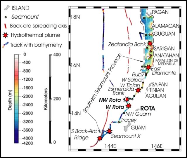 |
Figure 1. A map showing part of the Northern Mariana Islands and vicinity (an area roughly midway between the main island of New Guinea on the S, and Tokyo, Japan on the N). The islands shown include Guam, Rota, Saipan, and others. The map emphasizes the location of the active submarine volcano NW Rota 1 and the currently quiet submarine caldera West Rota. After Embley and others, 2004; courtesy of the American Geophysical Union. |
The ship towed a conductivity-temperature-depth (CTD)/rosette system to map and sample hydrothermal plumes over NW Rota 1. The 2003 tow data detected a vigorous, 200-m-thick layer of hydrothermal plumes above the volcano's summit. Chemical analysis of the 2003 plumes found high concentrations of particulate aluminum, sulfur, iron, and manganese, along with elevated 3He, a helium isotope considered diagnostic of a magmatic source and associated hydrothermal discharge. The active crater's summit depth was ~ 517 m.
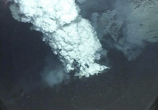
[During 27 March-18 April 2004], the RV Thompson revisited the Mariana Arc and found NW Rota 1 still vigorously active. William Chadwick and Robert Embley, National Oceanographic and Atmospheric Agency (NOAA), members of the cruise scientific staff, notified GVN that some video images from NW Rota 1 were taken with a ship-deployed remote vehicle (ROPOS-Remotely Operated Platform for Ocean Science). Videos posted on their web page showed views of the so-called "Brimstone Pit" (figures 2 and 3). Brimstone Pit represents a S-flank vent at a depth of 555 m, a spot ~ 40 m below the summit in rocky terrain. The videos and photos showed ash and sulfur bursts from the crater and a vent whose rim was covered with spatter (but probably not from this specific event). Water samples taken in a plume rising from the vent had temperatures of 30°C. Although incompletely mapped, the vent was roughly 20 m across and elliptical in outline; in the vertical dimension the vent appeared ~ 12 m deep and funnel-shaped.
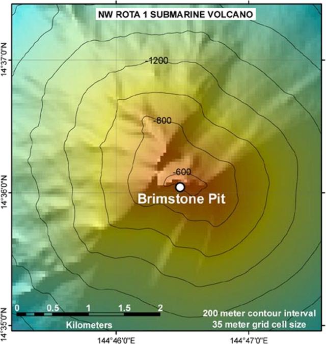 |
Figure 2. Bathymetry of NW Rota 1 showing the location of Brimstone Pit, [March 2004]. Courtesy of Bob Embley, NOAA. |
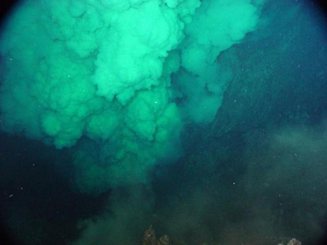 |
Figure 3. At NW Rota 1, the 555-m-deep submarine crater called Brimstone Pit discharged a dense, yellowish, particle-laden plume. This [30 March] 2004 photo was taken from a remote submarine vehicle, which captured the plume from the submarine vantage point, a relatively rare circumstance for shallow-depth submarine eruptions. At other times during the exploration, venting slowed or ceased, allowing views of the vent itself. Courtesy of W. Chadwick, NOAA. |
During the ROPOS dive, the activity at the crater was variable. At the beginning of the dive there was only a wispy plume escaping, allowing the observers to see into the crater. Later in the dive, the crater returned to pulsing activity with bigger, more vigorous plumes and small rocks raining down on the crater rim. Over the summit, which was still at a depth of ~ 517 m below sea level (as it was in 2003), the ROPOS images depicted a lot of diffuse venting of clear fluids. Intense geyser-like discharges flowed from the vents with jets rising to several ten's of meters. Cloudy water rose to form a plume several hundred meters above the summit. The pulsating jets carried sand- to gravel-size particles (a few centimeters across), ejecta that rained down on the crater rim out to a distance of ~ 10 m. Droplets of molten sulfur in the jets gave a yellowish cast to the billowing clouds, suggesting a temperature of at least 100°C (figure 3). The ROPOS came up from the last dive covered in sand and gravel, and in sulfur droplets, which had solidified and adhered to the submersible's body!
In overview, the [30-31 March 2004] dives with ROPOS documented NW Rota 1 in a magmatic phase of activity. The active vent showed time-varying behavior that included precipitation of sulfur droplets from the venting fluids, pulses of ejecta from the vent, and large amounts of fresh, glassy ejecta surrounding the crater. In addition, the study identified a turbid plume extending ~ 0.7-2.0 km from the volcano, reflecting an intensity unseen in 2003, and presumably the result of the vigorous summit activity.
The large amount of sulfur was believed to be forming by interaction of magmatic SO2 with water to form elemental sulfur and sulfurous acids. Bob Embley suggested that this magmatic event was in the early stages, as evidenced by negligible alteration of glassy lavas in spite of incredibly corrosive hot fluids. Team biologists noted that biota had only begun to colonize the impacted area.
Volcanic seismicity may accompany this event, although its detection may require a network of near-source ocean-bottom seismometers. At least from initial looks at their data, geophysicists at the NOAA Vents Program failed to detect any T-phase hydroacoustic signals coming from this vicinity. It should be noted, however, that their real-time hydrophones are located in the NE Pacific at a great distance from the volcano.
In an effort to enlist other seismic and acoustical instruments, Olivier Hyvernaud (Laboratoire de Détection et de Géophysique, CEA/DASE/LDG; with access to the French Polynesian network), and Roderick Stewart (CTBTO, the Preparatory Commission for the comprehensive nuclear-test-ban treaty, with access to Juan Fernandez island data) have been contacted. Thus far it appears that their systems lacked signals clearly attributable to NW Rota 1.
West Rota. During early April 2004 the RV Thompson also visited another newly identified submarine volcano that the 2003 survey group named "West Rota" (~ 56 km W of the island of Rota). It appeared inactive, and lacked a strong hydrothermal plume in the waters above it. However, it contained features indicative of a violent explosive eruption at some unknown time in the (geologically) recent past; namely, felsic volcanic rocks and the formation of a big caldera. The West Rota caldera is comparable in size to Crater Lake, Oregon (figure 4). The cruise scientists suspect that this volcano erupted violently a few thousand, to ten's of thousands, of years ago.
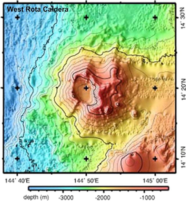 |
Figure 4. Although the erupting submarine volcano NW Rota 1 sits ~ 64 km NW of the island of Rota; slightly more to the W of Rota lies the recently identified and apparently quiet submarine caldera named West Rota. West Rota is elongate in the NW-SE direction and bears approximate size resemblance to the scenic lake-filled, 10-km-diameter caldera in the Cascade range of Oregon (USA), Crater Lake. West Rota's caldera floor lies at ~ 1.6 km depth below sea level. Courtesy of NOAA. |
References. Embley, R.W., Baker, E.T., Chadwick, Jr., W.W., Lupton, J.E., Resing, J.A., Massoth, G.J., and Nakamura, K., 2004, Explorations of Mariana Arc volcanoes reveal new hydrothermal systems: EOS-Transactions of the American Geophysical Union, v. 85, no. 4, p. 37 and 40.
Geological Summary. A submarine volcano detected during a 2003 NOAA bathymetric survey of the Mariana Island arc was found to be hydrothermally active and named NW Rota-1. The basaltic to basaltic-andesite seamount rises to within 517 m of the ocean surface SW of Esmeralda Bank, 64 km NW of Rota Island and ~100 km N of Guam. When Northwest Rota-1 was revisited in 2004, a minor submarine eruption from a vent named Brimstone Pit on the upper south flank about 40 m below the summit intermittently ejected a plume several hundred meters high containing ash, rock particles, and molten sulfur droplets that adhered to the surface of the remotely operated submersible vehicle. The active vent was funnel-shaped, about 20 m wide and 12 m deep. Prominent structural lineaments about a kilometer apart cut across the summit of the edifice and down the NE and SW flanks.
Information Contacts: William W. Chadwick, Jr., Cooperative Institute for Marine Resources Studies (CIMRS), NOAA Pacific Marine Environmental Laboratory (PMEL), 2115 SE OSU Drive, Newport, OR 97365 USA; Robert W. Embley, NOAA Pacific Marine Environmental Laboratory (PMEL), 2115 SE OSU Drive, Newport, OR 97365 USA (URL: http://oceanexplorer.noaa.gov/explorations/04fire/welcome.html); Douglas Wiens, Department of Earth and Planetary Sciences, Washington University, Campus Box 1169, One Brookings Drive, Saint Louis, MO 63130-4899, USA (URL: http://epsc.wustl.edu/seismology/).