Report on Kilauea (United States) — June 2004

Bulletin of the Global Volcanism Network, vol. 29, no. 6 (June 2004)
Managing Editor: Richard Wunderman.
Kilauea (United States) Surface lava flows and renewed ocean entries; lava tubes in June
Please cite this report as:
Global Volcanism Program, 2004. Report on Kilauea (United States) (Wunderman, R., ed.). Bulletin of the Global Volcanism Network, 29:6. Smithsonian Institution. https://doi.org/10.5479/si.GVP.BGVN200406-332010
Kilauea
United States
19.421°N, 155.287°W; summit elev. 1222 m
All times are local (unless otherwise noted)
During mid-2004 lava flows erupting from Kīlauea once again began reaching the ocean, where they slowly added new land to the SE coast of Hawai`i Island (figure 164). Lava began spilling into the ocean on 30-31 May 2004. Nearly a year before that, on 9 July 2003, the lava tube system feeding flows to the ocean ceased carrying lava, which instead escaped in a series of breakouts and numerous surface flows between the Pu`u `O`o vent and the coast. Hundreds of breakouts occurred between July 2003 and May 2004 within ~ 5 km of the vent.
 |
Figure 164. Map of lava flows on the S coastal part of Kīlauea as of 21 May 2004. The key at the right distinguishes 9 map units, lava flows erupted at various times. The Mother's Day flow began erupting on 12 May 2002 and continues to the present. More recent lava flows that erupted in November 2003 through 21 May 2004 included the Banana flow (labeled), which developed gradually, starting in the middle of April 2004. Stars indicate centers of formerly active, but now dead, rootless shields that formed along one or more lava tubes in the Mother's Day flow. The Kuhio flow (named for Prince Kuhio Kalaniana`ole and abbreviated on the map as PKK), was active most of the time from 20 March to 21 May 2004. As of May 21, most activity was located S of the rootless shield complex in the Banana flow. Courtesy U.S. Geological Survey Hawaiian Volcano Observatory. |
One of these flows, termed the Banana flow (see figure 164), started to advance down Pulama pali in April 2004. The Banana flow developed from breakouts from part of the Mother's Day lava tube, centered near the former Banana Tree kipuka (an "island" of undisturbed land completely surrounded by one or more lava flows). The breakouts became prominent in the middle of April, and lava started down Pulama pali shortly thereafter. The Banana Flow eventually reached the coastal flat on 2 May. It took nearly a month for the Banana flow to creep across the flat and enter the sea off Wilipe`a lava delta on 30 May. Interaction of the lava and water was not explosive. A spectacular set of photos of lava pouring into the ocean at this time appears on the Hawaiian Volcano Observatory website (figure 165, for example).
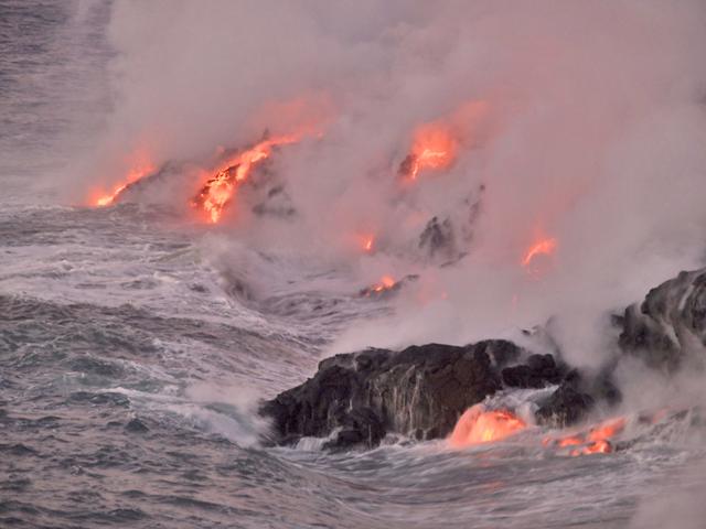 |
Figure 165. Lava entering the ocean on 23 July 2004 at the Wilipe'a delta. As waves broke upon the delta, the lowermost entry points of the advancing lava became totally submerged and quenched, forming a dark crust. As the water receded, the crust ruptured and molten lava spilled out. This cycle continued with each incident wave. Courtesy U.S. Geological Survey Hawaiian Volcano Observatory. |
On 13 June, two collapses occurred at Kīlauea's lava delta along its W sector, sending sizable chunks of the delta into the sea (figure 166). On 14 June, most lava was being supplied to the ocean through lava tubes, but several surface lava flows were visible on the delta and traveling down the old sea cliff behind the Wilipe`a delta. The larger eastern part of the lava delta had several active lava entries into the ocean, in general larger than those on the western part of the delta. All vents were active in the crater of Pu`u `O`o.
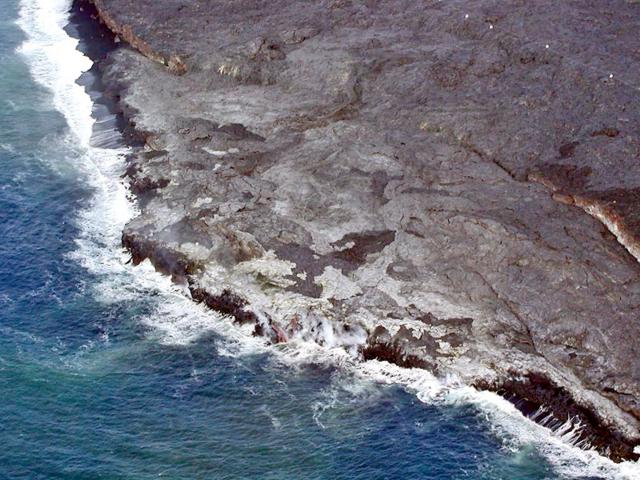 |
Figure 166. Aerial view on 23 July of the eastern part of the Banana flow lava delta, looking W. Streams of molten lava enter the ocean in the lower center part of the photo. The patchwork pattern on the delta partly results from numerous surface breakouts of lava from tubes during several previous days. A rope barrier cuts across the photo's upper right-hand corner. The barrier marks the limit of visitor access to the delta for their safety. Courtesy U.S. Geological Survey Hawaiian Volcano Observatory. |
Since March 2004, very weak background tremor continued at Kīlauea's summit along with a few long-period earthquakes. Tremor at Pu`u `O`o remained at its typical moderate levels through early June 2004, after which some higher levels were observed. Several episodes of inflation and deflation occurred during this time. One deflation-inflation event began 20 March and culminated 23 March with lava emerging from the S base of Pu`u `O`o cone. A weak swarm of low-frequency earthquakes and a 2-hour period of moderate-to-strong volcano tectonic earthquakes were recorded during 24-25 March.
Geological Summary. Kilauea overlaps the E flank of the massive Mauna Loa shield volcano in the island of Hawaii. Eruptions are prominent in Polynesian legends; written documentation since 1820 records frequent summit and flank lava flow eruptions interspersed with periods of long-term lava lake activity at Halemaumau crater in the summit caldera until 1924. The 3 x 5 km caldera was formed in several stages about 1,500 years ago and during the 18th century; eruptions have also originated from the lengthy East and Southwest rift zones, which extend to the ocean in both directions. About 90% of the surface of the basaltic shield volcano is formed of lava flows less than about 1,100 years old; 70% of the surface is younger than 600 years. The long-term eruption from the East rift zone between 1983 and 2018 produced lava flows covering more than 100 km2, destroyed hundreds of houses, and added new coastline.
Information Contacts: Hawaiian Volcano Observatory (HVO), U.S. Geological Survey, PO Box 51, Hawaii National Park, HI 96718, USA (URL: https://volcanoes.usgs.gov/observatories/hvo/).