Report on Guagua Pichincha (Ecuador) — June 2004
Bulletin of the Global Volcanism Network, vol. 29, no. 6 (June 2004)
Managing Editor: Richard Wunderman.
Guagua Pichincha (Ecuador) Phreatic explosions in November 2001 and October-December 2002
Please cite this report as:
Global Volcanism Program, 2004. Report on Guagua Pichincha (Ecuador) (Wunderman, R., ed.). Bulletin of the Global Volcanism Network, 29:6. Smithsonian Institution. https://doi.org/10.5479/si.GVP.BGVN200406-352020
Guagua Pichincha
Ecuador
0.171°S, 78.598°W; summit elev. 4784 m
All times are local (unless otherwise noted)
This report is a summary of notable activity at Guagua Pichincha since September 2001 (BGVN 26:09). On 26 November 2001, seismic data indicated that an ~ 20-minute-long phreatic explosion began around noon and that continuous tremor was recorded for ~ 16 hours after the eruption. This was the first explosion since 25 May 2001 (BGVN 26:09). Seismic signals from a relatively high number of rockfalls were also recorded. Two new craters were formed N of the 1981 crater by the 26 November 2001 event. Volcanic and seismic activity returned to low levels after 27 November, with only low-level fumarolic activity occurring.
The next event of note occurred on 11 October 2002 following 6 months with no explosions, as reported by the El Universo newspaper. Four phreatic eruptions were presumably triggered by groundwater encountering the magmatic system after several days of heavy rainfall. The eruption sent ballistic blocks to distances of 100-200 m from the vent. Subsequently, long-period and volcano-tectonic earthquakes and continuous background tremor were recorded until 17 October.
The Washington VAAC reported explosions at 2056 and 2115 on 3 November 2002 and at 2120 on 7 December. The Washington VAAC was unable to determine the heights of the plumes produced from the explosions in November, or state if they contained ash, because ash was already in the atmosphere from a large eruption that day at Reventador, ~ 100 km E of Guagua Pichincha.
On 17 April 2003, the Instituto Geofísico (IG) detected seismic signals indicating a possible minor eruption, but there were no visual signs of ash venting. Similar seismic signals in the previous few days were thought to result from outgassing. Several volcano-tectonic earthquakes, one long-period earthquake, and seismic signals of rockfalls were also reported. During the week of 23-29 April 2003, seismic unrest continued. Typically several earthquakes were detected per day, but 16 long-period earthquakes occurred on 26 April. Subsequently, the volcano exhibited low-to-moderate seismicity, including two earthquakes with M < 3 on 30 April and 1 May. Both had epicenters within an earthquake swarm centered N of Quito. Episodes of harmonic tremor appeared, most noteworthy on 4 and 5 May, with each episode lasting over 40 minutes. Cloud cover obscured the crater area for much of the week but improved visibility on 3 May enabled observers to see fumaroles sending condensate up to heights of 100 m.
During the afternoon of 7 January 2004, strong rains occurred and seismic signals attributed to rockfalls and lahars were recorded. A visit to the area by IG scientists on 13 January confirmed that a lahar had traveled down the NNE wall of the volcano's crater. In addition, there were small fractures in the SE sector of the volcano and in the crater but IG noted that this activity did not indicate a change in volcanic activity at Guagua Pichincha.
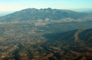
Geological Summary. Guagua Pichincha and the older Pleistocene Rucu Pichincha stratovolcanoes form a broad volcanic massif that rises immediately W of Ecuador's capital city, Quito. A lava dome grew at the head of a 6-km-wide scarp formed during a late-Pleistocene slope failure ~50,000 years ago. Subsequent late-Pleistocene and Holocene eruptions from the central vent consisted of explosive activity with pyroclastic flows accompanied by periodic growth and destruction of the lava dome. Many minor eruptions have been recorded since the mid-1500's; the largest took place in 1660, when ash fell over a 1,000 km radius and accumulated to 30 cm depth in Quito. Pyroclastic flows and surges also occurred, primarily to then W, and affected agricultural activity.
Information Contacts: Instituto Geofísico (IG), Escuela Politécnica Nacional, Apartado 17-01-2759, Quito, Ecuador (URL: http://www.igepn.edu.ec/); Washington Volcanic Ash Advisory Center (VAAC), Satellite Analysis Branch, NOAA/NESDIS E/SP23, NOAA Science Center Room 401, 5200 Auth Road, Camp Springs, MD 20746, USA (URL: http://www.ssd.noaa.gov/).

