Report on Asamayama (Japan) — February 2005
Bulletin of the Global Volcanism Network, vol. 30, no. 2 (February 2005)
Managing Editor: Richard Wunderman.
Asamayama (Japan) Maps of 2004 tephra deposits; radar images of the crater's interior and a dome
Please cite this report as:
Global Volcanism Program, 2005. Report on Asamayama (Japan) (Wunderman, R., ed.). Bulletin of the Global Volcanism Network, 30:2. Smithsonian Institution. https://doi.org/10.5479/si.GVP.BGVN200502-283110
Asamayama
Japan
36.406°N, 138.523°E; summit elev. 2568 m
All times are local (unless otherwise noted)
Setsuya Nakada and Yukio Hayakawa provided follow-up information on events at Asama since our last report (BGVN 30:01). Asama's largest recent explosion occurred on 1 September 2004, and the second largest, on 14 November 2004. Subsequent eruptions have been absent except for a small one in early December 2004.
The eruption that started on 1 September 2004 was characterized by an increase in the number of A-type earthquakes occurring during and after the main phase of explosions (based on data collected by the University of Tokyo's Earthquake Research Institute (ERI) and the Japan Meteorological Agency). Deep seismicity peaked at the end of 2004, but had subsequently remained moderate. GPS (global positioning system) instruments maintained ERI and the Geographical Survey Institute (GSI) disclosed inflation of the edifice. This inflationary trend has continued since mid-October 2004.
ERI undertook detailed analysis of earthquake hypocenters and the pressure source for the observed GPS data. This showed the existence of a dike-shaped magma reservoir trending WNW-ESE. The reservoir occurred just W of the summit and 1-2 km below sea level.
Around October 2004 the height of the lava filling the summit crater reached a maximum. Around that time the dome attained a height just ~70 m below the crater's lowest notch (an opening along the N rim). By the end of January 2005, in contrast, the center of the lava pool had deepened, possibly due to draining of the lava body back into the conduit.
A sequence of radar images provided glimpses into changeable features inside the steamy crater. Two images appear here, from 16 September and 15 December 2004 (figures 28 and 29). The former shows a flat-looking disk-shaped extrusion in the crater. The latter shows that the earlier extrusion had by this time become disrupted or perhaps buried.
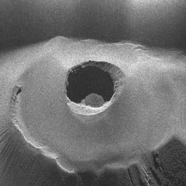 |
Figure 28. Radar image of Asama's summit crater taken from a Cessna airplane on 16 September 2004 by the Geographical Survey Institute, Japan. N is up. Radiated microwaves were transmitted from the N, at 4,290 m altitude, 2 km from the crater, with the off-nadir angle of 55 degrees. Courtesy of the Geographical Survey Institute. |
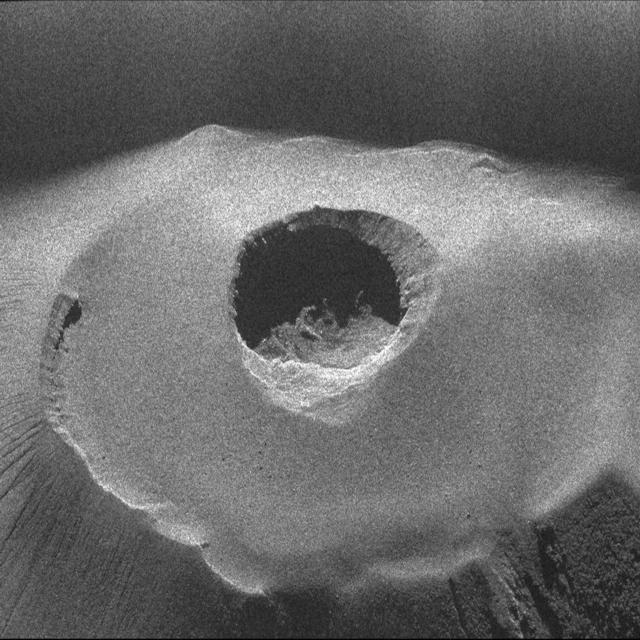 |
Figure 29. Radar image of Asama's summit crater taken from a Cessna on 15 December 2004 by the Geographical Survey Institute, Japan. N is up. Radiated microwaves were transmitted from the N, 2 km from the crater, with the off-nadir angle of 55 degrees. Courtesy of Geographical Survey Institute. |
Strong glowing at the summit was considered to be due to significant degassing after the main explosive phase. SO2 flux peaked around October (at ~5,000 metric tons a day) and has continued at a relatively high level, as much as 2,000 to 3,000 metric tons a day.
The eruptions emitted andesite (SiO2 ~61%), with high crystallinity, and containing partially melted sedimentary and other rock (felsic tuff?). The rock chemistry has remained uniform throughout the eruptions of the past several thousand years, though the inclusion of melted sedimentary rock was absent in products erupted prior to 2004.
Yukio Hayakawa provided a composite isomass map of 2004 Asama tephra deposits (figure 30). By far the largest deposit of the year erupted on 1 September. The smallest documented deposit occurred on 10 October. Ash deposits from activity on 1 September drifted NE, deposits from 16 September drifted SSE; 23 September, NNE; 29 September, N; 10 October, NE; and 14 November, E.
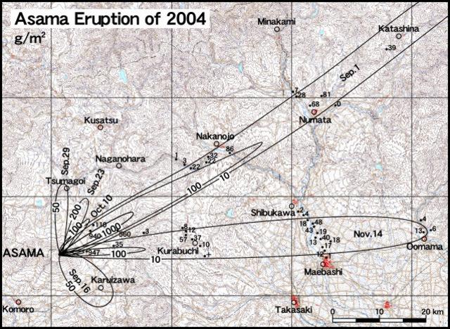 |
Figure 30. Isomass map of 2004 Asama tephra deposits erupted during September-November 2004. Open circles indicate cities; dots indicate sampling points where g/m2 of ash were measured; contours are in the same units. Courtesy Yukio Hayakawa. |
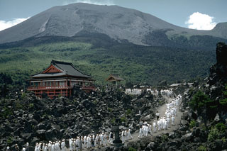
Geological Summary. Asamayama, Honshu's most active volcano, overlooks the resort town of Karuizawa, 140 km NW of Tokyo. The volcano is located at the junction of the Izu-Marianas and NE Japan volcanic arcs. The modern Maekake cone forms the summit and is situated east of the remnant of an older andesitic volcano, Kurofuyama, which was destroyed by a late-Pleistocene landslide about 20,000 years before present (BP). Growth of a dacitic shield volcano was accompanied by pumiceous pyroclastic flows, the largest of which occurred about 14,000-11,000 BP, and by growth of the Ko-Asamayama lava dome on the east flank. Maekake, capped by the Kamayama pyroclastic cone that forms the present summit, is probably only a few thousand years old and has observed activity dating back at least to the 11th century CE. Maekake has had several major Plinian eruptions, the last two of which occurred in 1108 (Asamayama's largest Holocene eruption) and 1783 CE.
Information Contacts: Setsuya Nakada, Volcano Research Center, Earthquake Research Institute (ERI), University of Tokyo, Yayoi 1-1-1, Bunkyo-ku, Tokyo 113, Japan (URL: http://www.eri.u-tokyo.ac.jp/VRC/index_E.html); Yukio Hayakawa, Faculty of Education, Gunma University, Aramaki 4-2, Maebashi Gunma 371-8510, Japan (URL: http://www.hayakawayukio.jp/English.html); Geographical Survey Institute, Ministry of Land, Infrastructure and Transport, 1, Kitasato, Tsukuba-shi, Ibaraki-ken 305-0811 Japan (URL: http://www.gsi.go.jp, with radar data (text in Japanese): http://www.gsi.go.jp/BOUSAI/ASAMA/); Japan Meteorological Agency, Otemachi, 1-3-4, Chiyoda-ku Tokyo 100-8122, Japan (URL: http://www.jma.go.jp/).