Report on Lopevi (Vanuatu) — March 2005

Bulletin of the Global Volcanism Network, vol. 30, no. 3 (March 2005)
Managing Editor: Richard Wunderman.
Lopevi (Vanuatu) Several lines of data confirm ongoing eruptions at this frequently erupting volcano
Please cite this report as:
Global Volcanism Program, 2005. Report on Lopevi (Vanuatu) (Wunderman, R., ed.). Bulletin of the Global Volcanism Network, 30:3. Smithsonian Institution. https://doi.org/10.5479/si.GVP.BGVN200503-257050
Lopevi
Vanuatu
16.507°S, 168.346°E; summit elev. 1413 m
All times are local (unless otherwise noted)
Previously, Bulletin reports for 2003 chiefly discussed either aviation-related reports about ash plumes or satellite data, such as the spectroscopic sensing of SO2 or infrared data in the form of MODVOLC thermal alerts (BGVN 27:12; v. 28, nos. 1 and 6; v. 29, no. 6). Since those reports more first-hand observations of conditions on the ground have emerged regarding Lopevi during 2003. Numerous thermal anomalies were detected by the MODIS satellite at Lopevi during July 2003 to March 2005 [table with incorrect data deleted]. Other observations also indicate activity continuing in 2005. Lopevi erupts nearly continuously, but, because it is an uninhabited island, activity often goes unreported.
Lopevi remains a danger for the region, and particularly for Paama Island, the closest inhabited island (6 km away). The explosive eruption of 2001 turned day into night for several hours, and the ashfall polluted the islanders' water supply to the point where the Australian Navy had to send a ship to bring residents drinking water. Since then, wells equipped with hand-operated pumps have been installed on Paama's N side, the flank threatened most directly. Lardy suggested that evacuating 1,633 inhabitants (the number cited in a 1999 census) is not realistic, but that the population could be supplied with dust-filtering face masks prior to the next eruption. The majority of Paama Island residents live on the W coast and even for the closest residents on Paama's N coast, the view of Lopevi is often limited.
Observations during 2003. Michel Lardy summarized the activity during 2003. The major volcanic events of June 2001 (BGVN 26:08) and of June 2003 (BGVN 28:06) appear to have originated at the adventive crater and through fractures in the island's N and W sides (figures 19 and 20). In particular, vents on the N, NW, and W opened in 2001 and 2003. Vent opening in 2001 occurred at 16° 31.879'S, 168° 19.846'E. A 2001 lava flow was prominent on the N flank. Radar interferometry depicted lava in 2001 on the volcano's N side, in the crater, and at several places on the N and W flanks.
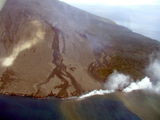 |
Figure 19. Lava flows down Lopevi's N flank and entering the sea during June(?) 2003. Note multiple lava flows, distinct vent areas, and the presence of at least two active points of entry into the ocean at the time of the photo. Photo credit, Shane Cronin (Massey University). |
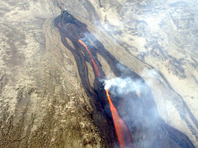 |
Figure 20. A closer look at the vents feeding lava flows down Lopevi's N flank during June(?) 2003. The vents formed along radial fractures. Photo credit, Shane Cronin (Massey University). |
Observations during 2004. During September 2004 thermal anomalies were detected four times, as many times as any month during the interval shown on table 2. However, none of the 28 September anomalies were unusually strong (~ 1 W m-2 sr-1 mm-1) and the spectral radiance of some other observations were several-fold larger (up to ~ 3.8 W m-2 sr-1 mm-1).
Volcano tour guide John Seach visited SE Ambrym volcano in November 2004. At that time he received reports from residents about previously unreported eruptions of Lopevi that occurred during 2004. Specifically, during September 2004, five large booming noises were heard coming from Lopevi by villagers in S Ambrym. Explosions were separated by 2 minutes. The next day there was ashfall on N and W Ambrym.
Observations during 2005. According to Seach, local observers in Vanuatu indicated ongoing eruptive activity at Lopevi beginning at the end of January 2005 and continuing into February.The Wellington VAAC is the key group providing aviators with reports on Lopevi eruptions and ash plumes. Their website posted all Volcanic Activity Advisories during 90 days prior to 28 March, but there were no reports for Lopevi during that interval. This absence of reports could be for a variety of reasons, such as relatively few if any plumes during that interval. Other reasons might also include extensive weather clouds screening satellite and pilot observations, or an absence of reports from pilots or people in the field to pass observations to the VAAC.
On 21 March 2005 IRD staff members observed Lopevi in usually clear weather conditions (figures 21 and 22). These two photos highlight Lopevi's summit crater and its off-axis NW-flank (adventive) crater. The adventive crater has been a feature of the edifice since the early 1960s (BGVN 24:02 and 24:07; the latter issue contains a map showing the then-recent crater).
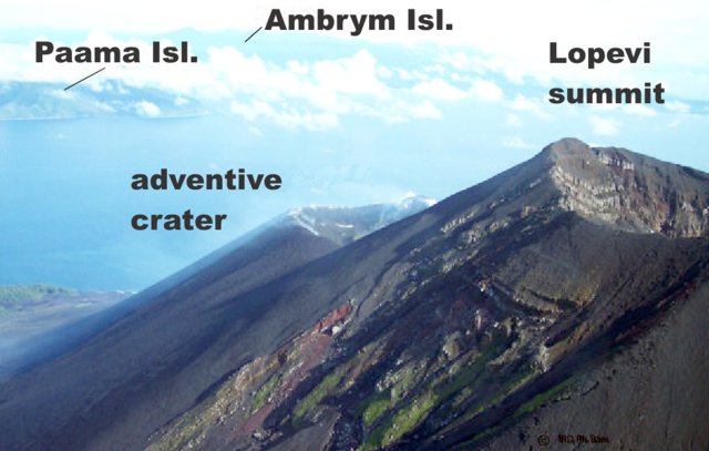 |
Figure 21. Annotated, N-looking view of Lopevi showing summit crater and adventive crater, and two other islands in the background. Copyrighted photo taken 21 March 2005 by P. Bani, IRD. |
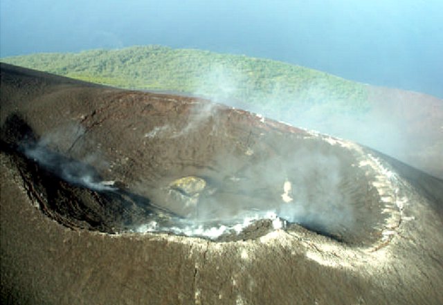 |
Figure 22. A photo of Lopevi's adventive NW-flank crater taken looking S from an altitude of ~ 1 km. White deposits occur along considerable portions of the larger crater's rim. The color version of this photo indicates a yellow region lies on the internal crater (the crater inside the larger crater and in the middle of the photo). Other areas of yellow color were also visible farther to the right, although in this shot it was masked by a hazy plume. The yellow color was attributed to sulfur deposits. Copyrighted photo taken 21 March 2005; provided courtesy of M. Lardy, IRD. |
The close-up photo (figure 22) shows a circular fracture along the crater's rim and circumferential fractures along its walls, probably the result of subsidence caused by the constant release of gas from the magma reservoir. White hydrothermal deposits were thought to have been associated with this gas release. The observers also saw yellow sulfur deposits near the internal crater and between it and the northern rim (to the right on the photo).
The perpendicular fractures visible just outside the crater (bottom center on the photo) were also judged most likely related to this subsidence associated with gas release. The small inner crater was a zone of active deposition (building up that crater). This pattern, apparently cyclical, has been visible since 1998, when Lopevi resumed an active phase following a quiet period of about fifteen years during which only fumaroles were observed. The summit crater (1,367 m elevation, figure 22) appears little changed when compared with the same crater 1995 photos taken in 1995. The major volcanic events of June 2001 (BGVN 26:08) and of June 2003 (BGVN 28:06) originated in the adventive crater and through fractures in the island's N and W sides.
Lardy also commented that "observations made since the 19th century suggest an activity cycle of 15 to 20 years, yet it remains difficult to forecast the occurrence of major eruptive phases within the cycle. Although there appears to be a recurrence of events in the month of June, it would be rash to attempt to predict the next eruption given the current state of our knowledge. Since November 2004, a micro-barometer has been set up on Paama Island. It is connected to the SSI network (which monitors compliance with the international ban on nuclear explosions) and has been recording the explosive volcanic events occurring on Lopevi and Ambrym Islands. Real time measurements should complement this monitoring system."
Reference. Le Pichon, A., and Drob, D., 2005, Probing high-altitude winds using infrasound from volcanoes: Jour. of Geophys. Res. (in press)
Geological Summary. The small 7-km-wide conical island of Lopevi, known locally as Vanei Vollohulu, is one of Vanuatu's most active volcanoes. A small summit crater containing a cinder cone is breached to the NW and tops an older cone that is rimmed by the remnant of a larger crater. The basaltic-to-andesitic volcano has been active during historical time at both summit and flank vents, primarily along a NW-SE-trending fissure that cuts across the island, producing moderate explosive eruptions and lava flows that reached the coast. Historical eruptions at the 1413-m-high volcano date back to the mid-19th century. The island was evacuated following major eruptions in 1939 and 1960. The latter eruption, from a NW-flank fissure vent, produced a pyroclastic flow that swept to the sea and a lava flow that formed a new peninsula on the western coast.
Information Contacts: Michel Lardy and Philipson Bani, Institut de Recherche pour le développement (IRD), CRV, BP A 5 Nouméa, New Caledonia; Morris Harrison, Department of Geology, Mines, and Water Resources, PMB 01, Port-Vila, Vanuatu (URL: http://www.suds-en-ligne.ird.fr/fr/volcan/vanuatu/lopevi1.htm); Shane Cronin, Soil and Earth Sciences Group, Institute of Natural Resources, Massey University, Private Bag 11 222, Palmerston North, New Zealand; John Seach, PO Box 16, Chatsworth Island, NSW 2469, Australia (URL: http://www.volcanolive.com/); Hawai'i Institute of Geophysics and Planetology, University of Hawaii and Manoa, 168 East-West Road, Post 602, Honolulu, HI 96822 (URL: http://modis.higp.hawaii.edu); Wellington Volcanic Ash Advisory Center (VAAC), MetService, PO Box 722, Wellington, New Zealand (URL: http://www.metservice.co.nz/).