Report on Soufriere St. Vincent (Saint Vincent and the Grenadines) — March 2005
Bulletin of the Global Volcanism Network, vol. 30, no. 3 (March 2005)
Managing Editor: Richard Wunderman.
Soufriere St. Vincent (Saint Vincent and the Grenadines) Anomalous winds spread sulfurous odors, causing unwarranted fears
Please cite this report as:
Global Volcanism Program, 2005. Report on Soufriere St. Vincent (Saint Vincent and the Grenadines) (Wunderman, R., ed.). Bulletin of the Global Volcanism Network, 30:3. Smithsonian Institution. https://doi.org/10.5479/si.GVP.BGVN200503-360150
Soufriere St. Vincent
Saint Vincent and the Grenadines
13.33°N, 61.18°W; summit elev. 1220 m
All times are local (unless otherwise noted)
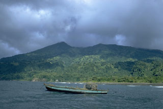
Widespread sulfurous odors and haze during mid-February 2005 on the island of St. Vincent and as far as the Grenadines (50-75 km S) led some people to conclude that the smells reflected increased output of volcanic gases from the Soufrière volcano, St. Vincent, a possible harbinger of an eruption. Sulfurous odors are common on the volcano's W flank, but less frequent on other parts of the island. Scientists determined that typical winds diminish the sulfurous odors over much of the island, and the onset of the odors resulted from changes in wind patterns rather than increased gas output or other demonstrable changes.
The Seismic Research Unit (SRU) collaborates with a small local unit called the Soufrière Monitoring Unit (which operates from the Ministry of Agriculture in Kingstown). The following report on the subject comes from SRU's Richard Robertson.
"During the night of 16 February and most of the day of 17 February there were widespread reports of sulfurous smells throughout southern St. Vincent and as far as the Grenadines. The day of the 17th was hazy; people put these two things together and came up with the conclusion that the volcano was acting up. The sulfur smell is unusual since the wind direction is such that most of the smell from the fumaroles at the summit of the volcano gets blown out to sea and is usually only smelt by a few residents on the eastern flank of the volcano.
"[SRU] . . . worked with Ms. Aisha Samuels, the head of the local volcano monitoring unit, to first investigate the report and later to quell fears that the volcano was doing anything unusual. We determined very early on that nothing serious was happening, since we have seismic stations both on the volcano and throughout the island [figure 3], none of which had recorded any increased seismicity. Further, we had just completed a GPS campaign on the island during January 2005, which revealed nothing unusual. It also involved two days of measurements on the summit of the volcano during which scientists were in very close proximity to the vent from which future eruptions will [likely] originate.
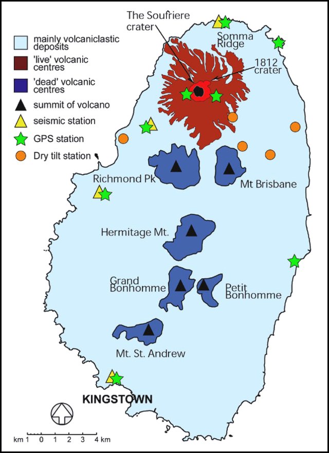 |
Figure 3. A sketch map showing the island of St. Vincent, including Soufrière volcano, other volcanic centers, geographic features, and Seismic Research Unit monitoring instrumentation (as of February 2004). January 2005 discussion of the instrumentation noted that it then included five seismic stations, eight GPS stations, and several dry-tilt sites. Courtesy of SRU. |
"We quickly determined that the reported 'activity' was due to an unusual southerly wind combined with the phenomena of Sahara dust which is common around this time of the year in St. Vincent and which results in very hazy conditions. However, to completely rule out the possibility of anything unusual happening in the crater that may not have been possibly detected by our various measurements, we advised the local Unit that they should visit the crater summit the next day (18 February)."
That visit found nothing out of the ordinary. Accordingly, SRU did not think it necessary to update their website since it was so insignificant—"'a 10 day wonder' as they say in the West Indies, or a 'pseudo-crisis.'" Such reports are common for St. Vincent and the entire region.
Geological Summary. Soufrière St. Vincent is the northernmost and youngest volcano on St. Vincent Island. The NE rim of the 1.6-km wide summit crater is cut by a crater formed in 1812. The crater itself lies on the SW margin of a larger 2.2-km-wide caldera, which is breached widely to the SW as a result of slope failure. Frequent explosive eruptions after about 4,300 years ago produced pyroclastic deposits of the Yellow Tephra Formation, which cover much of the island. The first historical eruption took place in 1718; it and the 1812 eruption produced major explosions. Much of the northern end of the island was devastated by a major eruption in 1902 that coincided with the catastrophic Mont Pelée eruption on Martinique. A lava dome was emplaced in the summit crater in 1971 during a strictly effusive eruption, forming an island within a lake that filled the crater. A series of explosive eruptions in 1979 destroyed the 1971 dome and ejected the lake; a new dome was then built.
Information Contacts: Richard Robertson, Seismic Research Unit, The University of the West Indies, St. Augustine, Trinidad (URL: http://www.uwiseismic.com/); Aisha Samuel, Soufriere Monitoring Unit, Ministry of Agriculture, St. Vincent.