Report on St. Helens (United States) — December 2005

Bulletin of the Global Volcanism Network, vol. 30, no. 12 (December 2005)
Managing Editor: Richard Wunderman.
St. Helens (United States) 2005 dome building amid comparative seismic, deformational quiet
Please cite this report as:
Global Volcanism Program, 2005. Report on St. Helens (United States) (Wunderman, R., ed.). Bulletin of the Global Volcanism Network, 30:12. Smithsonian Institution. https://doi.org/10.5479/si.GVP.BGVN200512-321050
St. Helens
United States
46.2°N, 122.18°W; summit elev. 2549 m
All times are local (unless otherwise noted)
Throughout the period covered by this report, August 2005 to December 2005, growth of the lava dome inside the crater of Mount St. Helens continued, accompanied by low rates of seismicity, low emissions of steam and volcanic gases, and minor production of ash. This report came from those posted on the website of the Cascades Volcano Observatory (CVO, part of the U.S. Geological Survey). The hazard status remained at Volcano Advisory (Alert Level 2); aviation color code Orange. During the month of August 2005, growth of the lava dome produced rockfalls, resulting in ash plumes that occasionally rose above the rim (figure 57). A rockfall on 21 August at 2056 generated a bright glow of hot rock and a thick ash plume. The induced atmospheric conditions temporarily affected radio transmissions from instruments in the crater.
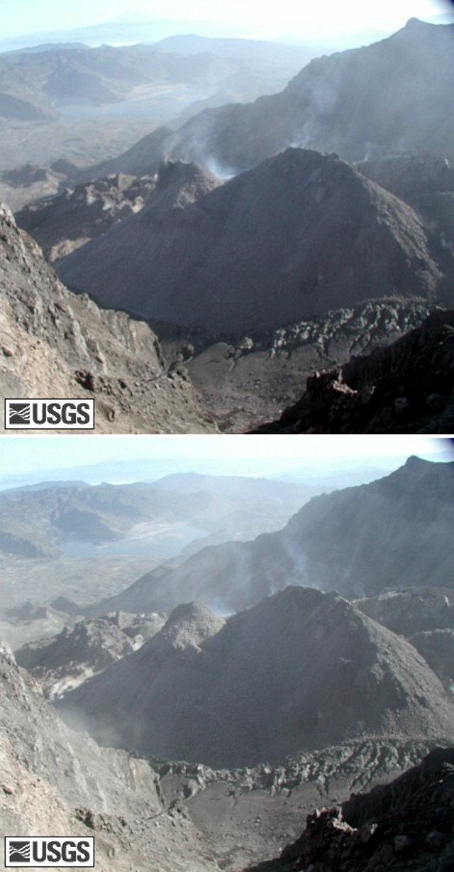 |
Figure 57. Before and after views of a rockfall that removed the upper portions of a spiny ridge on the growing St. Helens dome. View as seen from remote camera on the SW crater rim. Both photos were taken on 21 August 2005. Courtesy of USGS Cascades Volcano Observatory. |
A digital elevation model of the active lava dome, which was created from aerial photographs taken on 10 August, showed that the volume had grown to 62 million cubic meters with the average growth during late July and early August at about 2 million cubic meters per second.
During 31 August-6 September 2005, the new lava dome inside the crater of St. Helens continued to grow, accompanied by low rates of seismicity, low emissions of steam and volcanic gases, and minor production of ash. Images of the crater showed continued westward motion of the new lava dome.
On 6 September 2005, dry conditions and rockfalls from the lava dome generated occasional ash plumes that rose above the volcano and rapidly dissipated. During the week of 7-13 September 2005, growth of the lava dome continued and photos showed continued slumping of the central part of the dome and W motion of the presently active area. This movement continued throughout September 2005 and is illustrated in a time-series of images showing the active NW portion of the new lava dome as it continued to move W, butting into the W arm of a glacier, spawning rockfalls. This time-series of images is available on the CVO website.
During 28 September-4 October 2005, growth of the new lava dome inside the crater continued to grow, accompanied by low rates of seismicity, low emissions of steam and volcanic gases, and minor production of ash. Reanalysis of late September time-series photographs of the active part of the new lava dome indicated that points on the dome then moved NW and upward at about 5.5 m per day as extrusion continued.
Images taken on 10 of October showed that the pattern of dome growth established during the previous few months continued. The actively growing portion of the dome moved NW; pushing the W arm of the glacier against the W crater wall, causing the glacier to narrow, thicken, and become increasingly fractured. From the end of October to 21 November there were no significant changes in seismicity or edifice deformation.
During the previous few weeks, a prominent linear feature developed on the disintegrating "whaleback" that grew during the previous spring and summer and was currently located E of the actively growing part of the new lava dome (figure 58).
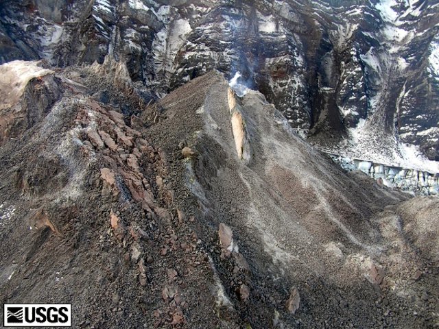 |
Figure 58. Linear feature developed at St. Helens on the Spring/Summer 2005 spine. Photo taken on 18 October 2005. Courtesy of USGS CVO. |
On 22 of November two notable rockfalls occurred at 1200 and shortly after 1500. Both produced dilute ash clouds that rose a few hundred meters above the crater rim, which are common during lava-dome growth (figure 59).
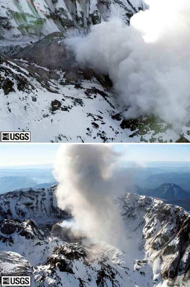 |
Figure 59. Two photos of dense local plumes created as a result rockfalls from St. Helens' dome on 22 November 2005. The photo on the top was taken from the NE; the photo on the bottom was taken from the NW. Courtesy of USGS CVO. |
The well-established pattern of tiny "drumbeat" earthquakes continued at a rate of one every 1-2 minutes; other monitoring data remained in typical ranges. Despite the continuing procession of earthquakes, the overall seismic energy release was very low compared to that during early phases of the eruption. Small rockfalls continued from the growing lava dome, with larger ones producing ash plumes that were visible above the crater rim.
The volume of the lava dome measured on 24 October was 70 million cubic meters?about 90% of the volume of the 1980-1986 dome. Repeat images taken on 15 December from fixed cameras within the crater and at the crater rim showed the seventh lava spine to emerge during the current activity. It continued to push upward and SW from a source just S of the 1980-186 dome (figure 60).
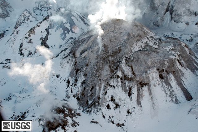 |
Figure 60. St. Helens' recent dome complex as seen from the NW. Four different stages of growth are visible in this image. They were given these sequence numbers: 4, 5, 6, and 7 (the latter for the one currently extruding). All occurred as whalebacks or spines in 2005. Photo was taken 8 December 2005 by Willie Scott. Courtesy of USGS CVO. |
During 21-27 December 2005, seismicity was marked by the repetitive small earthquakes, occurring every 2-3 minutes, that have come to characterize the past 15 months. Tiltmeters within 500 m of the new lava dome showed minute ground deformation; whereas the volcano's flanks were quiet. At the end of December 2005, St. Helens remained at Volcano Advisory (Alert Level 2); aviation color code Orange.
Table 8 gives a summary of the growth of the dome since October 2004. It was reported on 26 January 2006 that initial analysis of recent photographs from fixed cameras in the crater showed that the top of the currently active part of the new lava dome is at ~ 2,240 m elevation, which is about 90 m higher than it was in early November 2005. On several occasions during the eruption, parts of the dome have been considerably higher, for instance 2,365 m in July 2005. Those high points have since been lowered by disintegration, but still are higher than the top of the currently active part.
Table 8. St. Helens dome summit elevations and volumes compiled at a series of times during October 2004-January 2006. The dome summit elevations have decreased due to repeated failure of the unstable blocks, spires, and protrusions along the dome summits. Also, the method of assessing dome volumes changed in April 2005 (indicated by the asterisk). Courtesy USGS Cascades Volcano Observatory.
| Date | Volume (106 m3) | Elevation of dome top (m) |
| 04 Oct 2004 | 5 | -- |
| 13 Oct 2004 | 12 | -- |
| 04 Nov 2004 | 20 | -- |
| 01 Feb 2005 | -- | 2,332 |
| 21 Feb 2005 | -- | 2,341 |
| 10 Mar 2005 | 58 | 2,339 |
| 12 Apr 2005 | 47.5* | -- |
| 15 Jun 2005 | 54 | -- |
| Jul 2005 | 58 | 2,365 |
| 10 Aug 2005 | 62 | -- |
| 24 Oct 2005 | 70 | -- |
| Early Nov 2005 | -- | 2,150 |
| 26 Jan 2006 | -- | 2,240 |
Geological Summary. Prior to 1980, Mount St. Helens was a conical volcano sometimes known as the Fujisan of America. During the 1980 eruption the upper 400 m of the summit was removed by slope failure, leaving a 2 x 3.5 km breached crater now partially filled by a lava dome. There have been nine major eruptive periods beginning about 40-50,000 years ago, and it has been the most active volcano in the Cascade Range during the Holocene. Prior to 2,200 years ago, tephra, lava domes, and pyroclastic flows were erupted, forming the older edifice, but few lava flows extended beyond the base of the volcano. The modern edifice consists of basaltic as well as andesitic and dacitic products from summit and flank vents. Eruptions in the 19th century originated from the Goat Rocks area on the N flank, and were witnessed by early settlers.
Information Contacts: Cascades Volcano Observatory (CVO), U.S. Geological Survey, 1300 SE Cardinal Court, Building 10, Suite 100, Vancouver, WA 98683-9589, USA (URL: https://volcanoes.usgs.gov/observatories/cvo/).