Report on Tanaga (United States) — January 2006
Bulletin of the Global Volcanism Network, vol. 31, no. 1 (January 2006)
Managing Editor: Richard Wunderman.
Tanaga (United States) Weak, moderate depth seismicity
Please cite this report as:
Global Volcanism Program, 2006. Report on Tanaga (United States) (Wunderman, R., ed.). Bulletin of the Global Volcanism Network, 31:1. Smithsonian Institution. https://doi.org/10.5479/si.GVP.BGVN200601-311080
Tanaga
United States
51.885°N, 178.146°W; summit elev. 1806 m
All times are local (unless otherwise noted)
The Alaska Volcano Observatory (AVO) detected an increase in seismic activity beneath Tanaga beginning on 1 October 2005, with 15-68 earthquakes occurring daily. Previously, less than one earthquake had occurred per month since the seismic network was installed in 2003. The earthquakes were centered roughly 2 km NE of the summit at depths of 10-20 km below sea level. The largest event was M 1.7, with most earthquakes at M 0.5-1.5. Tanaga was at Concern Color Code Green on 5 October.
During 5-7 October, there was a marked increase in the rate of seismicity. The located earthquakes ranged in magnitude from 0.5 to 1.9 and ranged in depth from 6 to 12 km beneath the summit. In response, AVO raised the Concern Color Code to Yellow on 7 October. AVO reported that while the seismic activity represented a significant increase in rate, the size, depth, and character of the events were not indicative of imminent eruptive activity.
Elevated seismic activity below the young vents continued through 28 October 2005, although the rate of small earthquakes decreased slightly from the previous week. The activity that began on 1 October was at the highest level recorded since the seismic network was installed in 2003, so the Concern Color Code remained at Yellow. An unusual seismic signal on 17 October that persisted for several minutes may have been a landslide or small phreatic explosion, but satellite images detected no airborne ash. Beginning on 24 October, AVO observed weak, nearly continuous volcanic tremor in the vicinity of Takawangha volcano of the Tanaga volcano cluster. This was the first recorded tremor of this type. The daily number of small earthquakes continued to diminish from its peak in early October, but stayed above background levels.
AVO reported on 25 November 2005 that for several weeks seismicity beneath young volcanic vents on Tanaga Island decreased significantly from levels recorded in early October. Satellite images showed no anomalous temperatures or evidence of ash emissions. AVO reported that, based on the decrease in earthquake counts and frequency of tremor episodes, the likelihood of an eruption had diminished. Therefore, AVO downgraded the Concern Color Code to Green. According to AVO, the most recent eruptive activity at Tanaga was a lava flow observed in 1914.
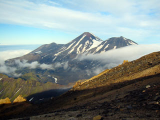
Geological Summary. Tanaga volcano, the second largest volcanic center of the central Aleutians, is the central and highest of three youthful stratovolcanoes oriented along a roughly E-W line at the NW tip of Tanaga Island. Ridges to the east and south represent the rim of an arcuate caldera formed by collapse of an edifice during the Pleistocene. Most Holocene eruptions originated from Tanaga volcano itself, which consists of two large cones, the western of which is the highest, constructed within a caldera whose 400-m-high rim is prominent to the SE. At the westernmost end of the complex is conical Sajaka, a double cone that may be the youngest of the three volcanoes. Sajaka One volcano collapsed during the late Holocene, producing a debris avalanche that swept into the sea, after which the Sajaka Two cone was constructed within the collapse scarp.
Information Contacts: Alaska Volcano Observatory (AVO), a cooperative program of the U.S. Geological Survey, 4200 University Drive, Anchorage, AK 99508-4667, USA (URL: http://www.avo.alaska.edu/), Geophysical Institute, University of Alaska, PO Box 757320, Fairbanks, AK 99775-7320, USA, and Alaska Division of Geological & Geophysical Surveys, 794 University Ave., Suite 200, Fairbanks, AK 99709, USA.