Report on Cleveland (United States) — January 2006
Bulletin of the Global Volcanism Network, vol. 31, no. 1 (January 2006)
Managing Editor: Richard Wunderman.
Cleveland (United States) 6 February 2006 eruption on remote, non-instrumented island
Please cite this report as:
Global Volcanism Program, 2006. Report on Cleveland (United States) (Wunderman, R., ed.). Bulletin of the Global Volcanism Network, 31:1. Smithsonian Institution. https://doi.org/10.5479/si.GVP.BGVN200601-311240
Cleveland
United States
52.825°N, 169.944°W; summit elev. 1730 m
All times are local (unless otherwise noted)
According to the Alaska Volcano Observatory (AVO), Mount Cleveland, a volcano on an uninhabited island in the central Aleutian chain, erupted at 0757 on 6 February 2006, sending a cloud of ash to 6.7 km (22,000 ft) altitude. Officials at AVO issued a Code Red warning for the volcano because the ash cloud was near a level where it could interfere with jet traffic, said Chris Waythomas, a U.S. Geological Survey geologist. There were no reports of falling ash. The nearest community is Nikolski, a tiny Aleut village of 31 people 73 km E of the volcano.
Cleveland's last major eruptive period was in March 2001 when three explosions occurred and the volcano produced significant ash plumes (BGVN 26:04). Discussion of that episode was renewed briefly at the end of the Augustine report in this issue (BGVN 31:01). That discussion (and cited references) noted that the ash cloud from a Cleveland eruption on 19 February 2001 had a modeled path that carried the cloud S, passing over Northern California. Two days after the eruption, aviators flying near San Francisco, California, smelled sulfurous gases, presumably from the Cleveland eruption. There were also minor ash emissions from July to October 2005 (BGVN 30:09).
AVO downgraded the level of concern color code for Cleveland from Red to Orange on 7 February 2006 at 1655 hours. No new ash emissions or thermal anomalies have been detected in clear to partly cloudy satellite views from the morning of 8 February. AVO noted that Cleveland does not have a real-time seismic network and therefore it is unable to monitor seismic changes.
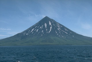
Geological Summary. The beautifully symmetrical Mount Cleveland stratovolcano is situated at the western end of the uninhabited Chuginadak Island. It lies SE across Carlisle Pass strait from Carlisle volcano and NE across Chuginadak Pass strait from Herbert volcano. Joined to the rest of Chuginadak Island by a low isthmus, Cleveland is the highest of the Islands of the Four Mountains group and is one of the most active of the Aleutian Islands. The native name, Chuginadak, refers to the Aleut goddess of fire, who was thought to reside on the volcano. Numerous large lava flows descend the steep-sided flanks. It is possible that some 18th-to-19th century eruptions attributed to Carlisle should be ascribed to Cleveland (Miller et al., 1998). In 1944 it produced the only known fatality from an Aleutian eruption. Recent eruptions have been characterized by short-lived explosive ash emissions, at times accompanied by lava fountaining and lava flows down the flanks.
Information Contacts: Alaska Volcano Observatory (AVO), a cooperative program of the U.S. Geological Survey, 4200 University Drive, Anchorage, AK 99508-4667, USA (URL: http://www.avo.alaska.edu/), Geophysical Institute, University of Alaska, PO Box 757320, Fairbanks, AK 99775-7320, USA, and Alaska Division of Geological & Geophysical Surveys, 794 University Ave., Suite 200, Fairbanks, AK 99709, USA; Washington Volcanic Ash Advisory Center (VAAC), Satellite Analysis Branch (SAB), NOAA/NESDIS E/SP23, NOAA Science Center Room 401, 5200 Auth Road, Camp Springs, MD 20746, USA (URL: http://www.ospo.noaa.gov/Products/atmosphere/vaac/).