Report on Montagu Island (United Kingdom) — March 2006
Bulletin of the Global Volcanism Network, vol. 31, no. 3 (March 2006)
Managing Editor: Richard Wunderman.
Montagu Island (United Kingdom) January 2006 visit documenting steam and new lava flows
Please cite this report as:
Global Volcanism Program, 2006. Report on Montagu Island (United Kingdom) (Wunderman, R., ed.). Bulletin of the Global Volcanism Network, 31:3. Smithsonian Institution. https://doi.org/10.5479/si.GVP.BGVN200603-390081
Montagu Island
United Kingdom
58.445°S, 26.374°W; summit elev. 1370 m
All times are local (unless otherwise noted)
Recent volcanism on Montagu Island was discovered based on satellite information (BGVN 30:11). Thanks to a visit from the South African icebreaker MV SA Agulhas, the first photographs of the island are now available, taken from just offshore. The Agulhas is an Antarctic supply and oceanographic research vessel built in the late 1970s; it is affiliated with the South African Department of Environmental Affairs and Tourism, Antarctica and Islands Division. She left Cape Town on 1 December 2005, and her journey was the focus of several reports (e.g., Hunter, 2005). The westerly position of pack ice during the course of this voyage enabled the Agulhas to visit Penguin Bukta, an indentation (bay) in the coastal ice shelf (figure 13).
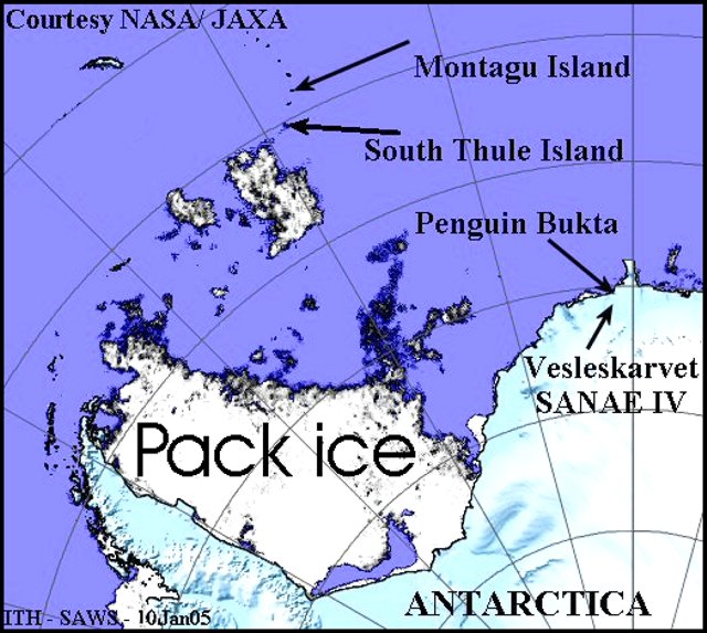 |
Figure 13. A map indicating the location of Montagu island with respect to features in the region. The pack ice is mobile and the position shown refers to conditions on 10 January 2006 as mapped by satellite radar (NASA/JAXA). Courtesy of Ian Hunter, South African Weather Service. |
The Agulhas departed Penguin Bukta on 8 January to deploy drifting weather buoys and to install an automatic weather station on South Thule island at the extreme S end of the South Sandwich Islands. Besides the usual hazards of Antarctic travel and navigation, the South Sandwich Islands were the scene of some severe undersea earthquakes as the Agulhas entered those waters. This was of concern because such earthquakes can cause significant bathymetric change. The US Geological Survey posted detailed information on two large 2006 earthquakes to the E of the islands. The first, on 2 January, had M 7.3 and, fortunately, a moderately deep focal depth of 46 km.
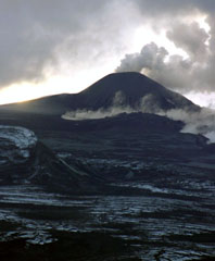
The ship reached offshore of the remote, uninhabited Montagu island in mid-January 2006 (figures 14 and 15). These pictures were forwarded to the Smithsonian by Ian Hunter who received them from Frikkie Viljoen (the ice navigator), and Dave Hall (the ship's Master) after the Agulhas returned from Antarctica on 19 February 2006.
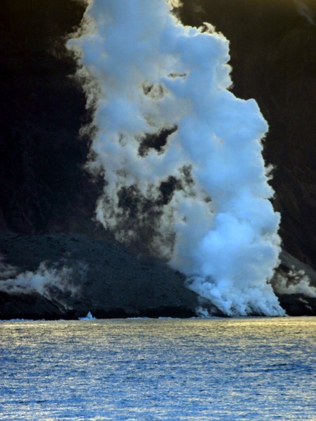 |
Figure 14. Lava from Montagu Island eruption entering the sea. The photo was taken on 13 January 2006 from the SA Agulhas while lying to the N of the Island. The geometry of the setting given here is based on the MODIS photo taken on 9 September 2005 (BGVN 30:11) that clearly indicates the lava flow streaming N into the sea. Courtesy of Dave Hall and Frikkie Viljoen, SA Agulhas, and Ian Hunter, South African Weather Service. |
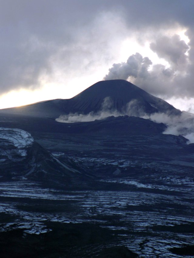 |
Figure 15. Photo taken on 13 January 2006 from the SA Agulhas from N of Montagu Island showing the lava field formed by the recent eruption. Courtesy of Dave Hall and Frikkie Viljoen, SA Agulhas, and Ian Hunter, South African Weather Service. |
In an e-mail message to Hunter on the return leg of the voyage (on 16 January), Hall noted the following. "By now you will have heard that we successfully deployed the new weather station at Thule Island and had a good look at the eruption on Montagu. We got to within 1.5 miles [2.4 km] of the lava flow, but it was strangely disappointing. Although it was during the evening it was still full daylight so the lava flow was just the same colour as the surrounding rock, not dramatic at all! The most visible feature was the steam plume as the hot lava entered the sea. The top of the island was covered in cloud but that did part long enough to get a quick sighting of the summit, emitting the smoke and ash cloud."
John Smellie of the British Antarctic Survey reported hearing from a Falklands contact that an RAF flight sent at Christmas 2005 had taken photos and reported the eruption was "over." In addition, there could also be first-hand news from a yacht that was to be in the area during January 2006.
Reference. Hunter, Ian, (12 January) 2006, International Support for the SA Agulhas's mission in Antarctica, in Ports & Ships, Shipping News?reporting from the harbours of South Africa & Southern Africa (URL: http://www.ports.co.za/didyouknow/)
Geological Summary. The largest of the South Sandwich Islands, Montagu consists of a massive shield volcano cut by a 6-km-wide ice-filled summit caldera. The summit of the 11 x 15 km island rises about 3,000 m from the sea floor between Bristol and Saunders Islands. Around 90% of the island is ice-covered; glaciers extending to the sea typically form vertical ice cliffs. The name Mount Belinda has been applied both to the high point at the southern end of the summit caldera and to the young central cone. Mount Oceanite, an isolated peak at the SE tip of the island, was the source of lava flows exposed at Mathias Point and Allen Point. There was no record of Holocene activity until MODIS satellite data, beginning in late 2001, revealed thermal anomalies consistent with lava lake activity. Apparent plumes and single anomalous pixels were observed intermittently on AVHRR images from March 1995 to February 1998, possibly indicating earlier volcanic activity.
Information Contacts: Ian T. Hunter, South African Weather Service, Private Bag X097, Pretoria 0001, South Africa (URL: http://www.weathersa.co.za/); Department of Environmental Affairs and Tourism, Antarctica and Islands Division, Private Bag X447, Pretoria 0001, South Africa; John Smellie, British Antarctic Survey, Natural Environment Research Council, High Cross, Madingly Road, Cambridge CB3 0ET, United Kingdom (URL: https://www.bas.ac.uk/).