Report on Augustine (United States) — April 2006
Bulletin of the Global Volcanism Network, vol. 31, no. 4 (April 2006)
Managing Editor: Richard Wunderman.
Augustine (United States) Dome building eruptions continuing through late March 2006 and later
Please cite this report as:
Global Volcanism Program, 2006. Report on Augustine (United States) (Wunderman, R., ed.). Bulletin of the Global Volcanism Network, 31:4. Smithsonian Institution. https://doi.org/10.5479/si.GVP.BGVN200604-313010
Augustine
United States
59.3626°N, 153.435°W; summit elev. 1218 m
All times are local (unless otherwise noted)
Although the previous report (BGVN 31:01) noted Augustine's events through 22 February 2006, this one overlaps and further discusses some aspects of behavior during late January through 1 February 2006. This report then continues with summaries of Alaska Volcano Observatory (AVO) reports during 24 February to 26 March 2006.
After eight months of increasing seismicity, gas-and-steam emissions, and phreatic eruptions in December 2005, Augustine began magmatic eruptions on 11 January 2006 (BGVN 30:12). Eruptions continued throughout January, producing ash clouds up to ~ 9 km altitude. The eruption was described by Jon Dehn (University of Alaska Fairbanks, personal communication) as occurring in the following three phases: I) 11-28 January; II) 29 January-4 February; and III) 5 February and into at least late March.
During 11 January to 21 March 2006 (70 days), the Anchorage Volcanic Ash Advisory Center (VAAC) issued text reports (Volcanic Activity Advisories) on Augustine 567 times (averaging 8.1 reports per day). These alerted the aviation community to the ongoing airborne-ash hazards.
Augustine lies ~ 277 km SW of Anchorage's airport, a key hub for flights across the North Pacific. According to the US Department of Transportation, during 2003 Anchorage's airport supported the largest tonnage of any in the US, and functioned as the 8th busiest in the US by value of shipments. Augustine's eruptions can potentially impact aviation and operations at the airport, and more generally, they complicate North Pacific air travel.
Plumes, 28 January-1 February. AIRS SO2 retrievals for Augustine plumes on 28 and 29 January were provided by Fred Prata (figure 27). He commented that the SO2 "blobs" seem to spread out rather than elongate into a plume shape, possibly because of calm winds or intermittent ejections.
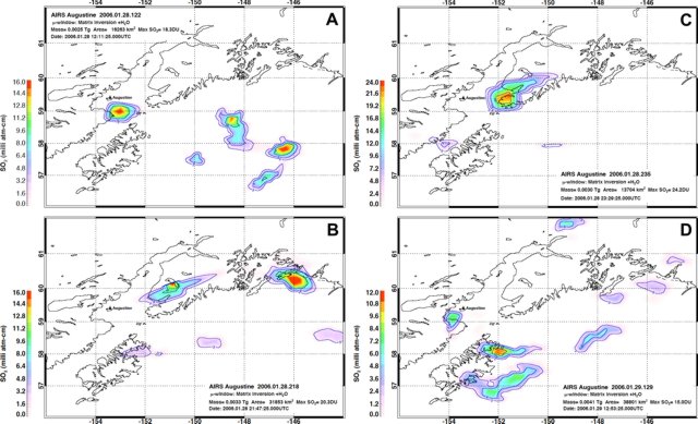 |
Figure 27. Atmospheric SO2 from the AIRS instrument for Augustine plumes on 28 and 29 January 2006. Details of the processing and resulting analysis are included on the four panels, which correspond to these dates and times (UTC): a) 12:11:25 on 28 January, b) 21:47:25 on 28 January, c) 23:29:25 on 28 January, and d) 12:53:25 on 29 January. All images provided courtesy of Fred Prata (Norwegian Institute for Air Research). |
Shortly after the 28-29 January plumes mentioned above, on 30 January, an overflight by AVO confirmed a ~ 5-km-tall volcanic cloud and small explosions and associated pyroclastic flows. The airborne observations indicated that a considerable amount of ash was being produced during this time period from small explosions and associated pyroclastic flows. Figures 28 and 29 show images from 30 January. AVO also presented 31 January thermal infrared images similarly indicative of vigorous eruptions and fresh pyroclastic flows (figure 30).
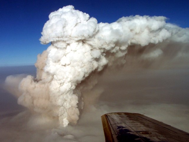 |
Figure 28. Aerial view of Augustine during an eruption on 30 January 2006. The volcano was shrouded in ash cloud. The plume blew NE. Courtesy of Pavel Izbekov, AVO/UAF-GI. |
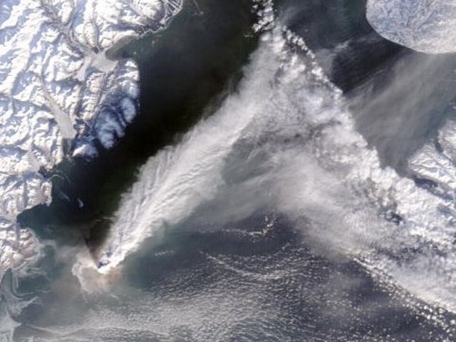 |
Figure 29. A MODIS satellite image for 30 January at 12:30:00 showing an Augustine ash and steam plume. This image was collected at approximately the same time as an AVO overflight, and shows the volcanic cloud moving NE at ~ 4.8 km altitude. Processing and interpretation courtesy of Dave Schneider, USGS-AVO. Image courtesy of MODIS Rapid Response Project at NASA/GSFC. |
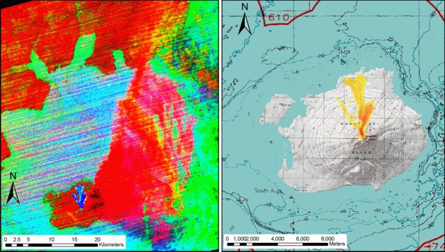 |
Figure 30. Two 31 January 2006 (at 22:50:44 AST; 1 February 2006 UTC) night-time ASTER thermal infrared (TIR) images showing hot pyroclastic flow deposits on Augustine's N flank. The image on the left also shows a broad ash and SO2 plume extending ENE. Image processing and interpretation courtesy of Rick Wessels (AVO-USGS); ASTER data courtesy of NASA/GSFC/METI/ERSDAC/JAROS, and US/Japan ASTER Science Team. |
René Servranckx looked at several images from 1 February 2006 and sent associated messages and links to the Volcanicclouds listserv. He found a hotspot at Augustine and identified various cloud features from plumes. Using a NOAA-12 IR image taken at 1542 UTC, Servranckx could not detect an ash signature in the split window.
On 4 February, Ken Dean (UAF) posted a message on the Volcanicclouds listserv discussing Augustine for 28 January-1 February. He noted that, regarding SO2 detection in northern Alaska, they had been monitoring the atmospheric transport direction using Puff, a modeling routine for predicting the atmospheric dispersal of ash clouds. Generally speaking, trajectories were to the N and over Fairbanks. Accordingly, lidar systems at both the UAF's Geophysical Institute and ~ 50 km N of Fairbanks at the Poker Flat Rocket Range were turned on to see if they could detect volcanic aerosols from the eruption. Lidar uses laser energy to probe the atmosphere, where it can detect suspended material such as volcanic aerosols in identifiable regions. Preliminary results indicated volcanic aerosols at 4.6-6.6 km altitude in the atmosphere above both Fairbanks and Poker Flats. There could also have been volcanic aerosols at lower altitudes in the weather clouds.
Dean also noted that ground-based event-monitoring collectors set out by Cathy Cahill (UAF) sampled volcanic aerosols and possible traces of ash at Fairbanks. He noted that these observations and trajectories were consistent with Prata's SO2 observations and Servranckx's back trajectories.
24 February-26 March 2006. On 24 February, AVO noted repeated and ongoing unrest during the past week. This included relatively low but above-background seismicity that indicated small, intermittent rockfalls and avalanches from the lava dome. Satellites detected a persisting thermal anomaly in the summit area. These data, along with a 20 February visit to the island, indicated continued slow growth at the summit lava dome. A veil of fresh, light ash dressed Augustine's flanks. The ongoing AVO reports into March noted similar processes and observations, and soon included mention of ash plumes, a lava flow, and a pyroclastic flow.
An overflight of the volcano on 1 March revealed a short, stubby lava flow that extended NE from the dome, terminating at ~ 1 km elevation. AVO noted a small dilute ash plume as well as a 20-minute interval of elevated seismicity at 1010 on 5 March, interpreted as a small explosion with associated ash emission, although low clouds obscured web-camera views. On 6 March AVO reported seismic signals and the low-light camera in Homer suggested rockfalls and avalanches. Although Augustine's plumes in this time frame were generally characterized as local, dilute, and under ~ 1 km above the summit, pyroclastic flows were also seen on 6 March.
Early on the morning of 8 March, AVO's seismometers began recording periods of discrete, repetitive, small events. These signals were taken to indicate ongoing dome growth, observations consistent with those from web cameras, which revealed minor ash emissions and mass wasting. Reports on 8 and 9 March discussed seismicity sufficiently elevated as to sometimes saturate several instruments. In addition, cameras portrayed two areas of high thermal flux. AVO initially interpreted these observations as including elevated rates of lava extruding into the dome, possibly with vigorous lava movement, and block-and-ash flows.
Later reports disclosed further details from around 9 March. AVO's 8-10 March reports noted that the summit was steaming more vigorously than the previous 3-4 weeks. A brownish-orange plume rose from the top of the summit lava dome. Fumaroles on the S and W side of the dome were the source of the most vigorous steaming. Areas of bare ground on the upper W and S flanks had substantially enlarged since 1 March. The greatest amounts of steam came from bare areas on the upper NW flank. Web-camera images and observations from overflights on 8 and 9 March indicated regular small-scale collapses of the summit lava dome. Usually these collapse events produce block-and-ash flows and small diffuse ash clouds. Block-and-ash flows to the E to NE sectors extended to within about 1 km of the coastline. Dilute ash clouds were observed rising from the block-and-ash flows to about the level of the summit and drifting away with the wind.
10 March seismicity included prolonged volcanic tremor and an increase in the frequency of small volcano-tectonic earthquakes. Block-and-ash flows, rock avalanches, and rockfalls originating from the summit lava dome continue to be recorded by the seismic network, particularly at the E flank station.
The 10 March report stated that "Satellite and low-light camera images obtained intermittently throughout the week show that thermal anomalies in the summit area and on the upper NE flank persist. On several evenings this past week, a low-light camera at the AVO site in Homer captured hot avalanches in progress and prolonged periods of incandescence. AVO also received several reports from observers in Homer and Nanwalek of summit glow in the evening hours. Airborne measurements of gas emissions made on March 9 indicate both SO2 and CO2 gas in the plume. This is the first time since the fall of 2005 that CO2 has been a component of the gas plume and likely indicates the presence of new magma entering the volcanic system."
The AVO report for 17 March chronicled low-level eruptive activity. It said that the past week's seismicity changed from periods of prolonged tremor and closely spaced discreet events to episodic short-duration events. Observers interpreted the change as indicating that steady effusion of lava and dome growth had given way to slower effusion of lava and intermittent block-and-ash flows, rock avalanches, and rock-falls from the summit lava dome. On several evenings during the week, clear atmospheric conditions enabled low-light cameras at the AVO site in Homer to capture hot avalanches and prolonged periods of incandescence in both the summit area and on the upper NE flank. Satellite images also showed thermal anomalies.
The 17 March report said that overflights indicated two lava flows were seen on the N and NE flanks. They advanced slowly. Occasional collapses of the lava flow fronts shed hot blocks and produce minor ash emissions. Estimates using photographs indicated that the new lava dome stood ~ 70 m higher than the one formed in 1986.
Little new information was discussed in AVO reports issued on 20-26 March. The 26 March report included the remark that satellite views were then obscured by cloud cover; however, vigorous steaming from the summit was visible with the on-island web camera.
Correction. A previous Augustine report (BGVN 30:12; issued in early 2006) had a typographic error in the title: "Eruptions begin 11 January 2005 and eight outbursts occur by late January)." The year has since been changed on our website to 11 January 2006.
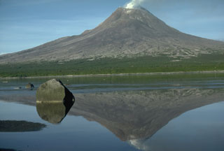
Geological Summary. Augustine volcano, rising above Kamishak Bay in the southern Cook Inlet about 290 km SW of Anchorage, is the most active volcano of the eastern Aleutian arc. It consists of a complex of overlapping summit lava domes surrounded by an apron of volcaniclastic debris that descends to the sea on all sides. Few lava flows are exposed; the flanks consist mainly of debris-avalanche and pyroclastic-flow deposits formed by repeated collapse and regrowth of the summit. The latest episode of edifice collapse occurred during Augustine's large 1883 eruption; subsequent dome growth has restored the edifice to a height comparable to that prior to 1883. The oldest dated volcanic rocks on Augustine are more than 40,000 years old. At least 11 large debris avalanches have reached the sea during the past 1,800-2,000 years, and five major pumiceous tephras have been erupted during this interval. Recorded eruptions have typically consisted of explosive activity with emplacement of pumiceous pyroclastic-flow deposits followed by lava dome extrusion with associated block-and-ash flows.
Information Contacts: Jon Dehn, Cathy Cahill, Ken Dean, and Pavel E. Izbekov, Geophysical Institute, University of Alaska Fairbanks, 903 Koyukuk Drive, PO Box 757320 Fairbanks, AK 99775-7320, USA; Anchorage VAAC, Alaska Aviation Weather Unit, National Weather Service, 6930 Sand Lake Road, Anchorage, AK 99502, USA (URL: http://aawu.arh.noaa.gov/vaac.php); Fred Prata, Norwegian Institute for Air Research, P.O. Box 100, 2027 Kjeller, Norway; René Servranckx, Montreal Volcanic Ash Advisory Centre, Canadian Meteorological Centre, Meteorological Service of Canada, 2121 North Service Road, Trans-Canada Highway, Dorval, Quebec, H9P 1J3 Canada; Alaska Volcano Observatory (AVO), a cooperative program of the U.S. Geological Survey, 4200 University Drive, Anchorage, AK 99508-4667, USA (URL: http://www.avo.alaska.edu/), Geophysical Institute, University of Alaska, PO Box 757320, Fairbanks, AK 99775-7320, USA, and Alaska Division of Geological & Geophysical Surveys, 794 University Ave., Suite 200, Fairbanks, AK 99709, USA.