Report on Masaya (Nicaragua) — April 2006

Bulletin of the Global Volcanism Network, vol. 31, no. 4 (April 2006)
Managing Editor: Richard Wunderman.
Masaya (Nicaragua) Intermittent ash eruptions November 2003-March 2005; continuing incandescence
Please cite this report as:
Global Volcanism Program, 2006. Report on Masaya (Nicaragua) (Wunderman, R., ed.). Bulletin of the Global Volcanism Network, 31:4. Smithsonian Institution. https://doi.org/10.5479/si.GVP.BGVN200604-344100
Masaya
Nicaragua
11.9844°N, 86.1688°W; summit elev. 594 m
All times are local (unless otherwise noted)
Previously reported behavior at Masaya through 22 September 2003 consisted primarily of incandescence from Santiago crater (BGVN 28:10). Monthly reports prepared by the Instituto Nicarag?ense de Estudios Territoriales (INETER) since that time noted continuing seismicity and incandescence through March 2005. A small explosions was reported on 29 November 2003. Masaya Volcano National Park workers also reported two ash-and-gas explosions at 0121 on 12 December 2003. A collapse event within the crater was noted on 22 June 2004. A report from the Washington Volcanic Ash Advisory Center (VAAC) noted that on 4 July 2004 at 0015 local time, a narrow plume of steam and/or ash from Masaya was visible on satellite imagery extending to the SW. An hour later the plume had extended ~ 12 km from the summit. The report below notes changes induced in Santiago crater after a landslide in early March 2005. A magnitude 1.9 earthquake at a depth of 2.2 km below Masaya on 30 March 2005 was followed by rumbling noises and gas-and-ash emissions.
Field work during February-March 2005. Patricia Nadeau and Glyn Williams-Jones sent us a report of an intensive, multi-component field campaign conducted at Masaya from 16 February 2005 to 12 March 2005. Two FLYSPEC ultraviolet spectrometers were used in tandem with two Microtops sun photometers to constrain passive SO2 and aerosol fluxes and also to evaluate potential downwind loss of SO2 by conversion to aerosols. Additionally, self-potential geophysical measurements were performed at Masaya's summit in a preliminary attempt to delineate the hydrothermal system of the volcano.
On the morning of 3 March, Park workers reported that a landslide had occurred within Santiago crater the previous night. A visibly diminished plume from the crater's active vent suggested that the landslide may have caused a blockage that reduced the escape of SO2 (figures 20 and 21).
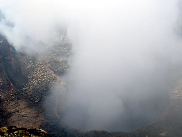 |
Figure 20. A photo taken from the tourist parking lot on 1 March 2005 showing the inner crater at Masaya emitting a large plume prior to the 2-3 March 2005 landslide. The diameter of the crater in this view is estimated to be 150-200 m. Courtesy of Patricia Nadeau and Glyn Williams-Jones. |
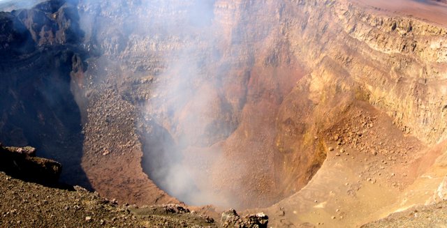 |
Figure 21. A view into the Santiago Crater at Masaya and its diminished plume rising from the inner crater, as taken from the tourist parking lot on 3 March 2005. The diameter of the outer crater is approximately 500 m; the inner crater is about 200 m across. Courtesy of Patricia Nadeau and Glyn Williams-Jones. |
The visual observations were supported by subsequent SO2-flux measurements, which confirmed a significant drop in SO2 emissions from an average of ~ 300 tons/day prior to the landslide to an average of ~ 80 tons/day following the landslide (figure 22). This decrease in emissions led to concerns over the possibility of a small vent-clearing explosion such as the one that occurred on 23 April 2001 (BGVN 26:04). That explosion was preceded by a similar drop in SO2 emissions for several weeks due to a blockage of the vent that was active at the time. The 2001 explosion resulted in the opening of a new vent, which has since been the site of Masaya's degassing. After the 2001 explosion, the previously active vent no longer degassed and was assumed to be completely inactive.
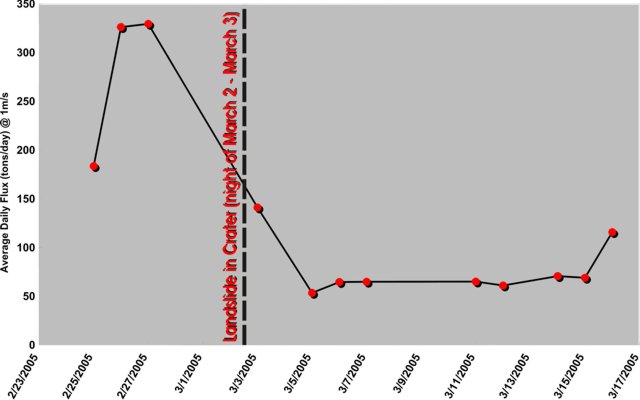 |
Figure 22. Graph showing Masaya's daily SO2 fluxes during 25 February 2005-17 April 2005 (normalized to a wind speed of 1 m/s) before and after the landslide during the night of 2-3 March 2005. Courtesy of Patricia Nadeau and Glyn Williams-Jones. |
In the days following the 2 March 2005 landslide, gas output was monitored closely, both visually and with the FLYSPEC, for any further decreases, which could have been indicative of further blockage and possible pressurization. Visual observations of the crater on the nights of 4 March and 11 March revealed that while the currently degassing vent was not incandescent, the older vent (believed to be inactive after the April 2001 explosion) was indeed incandescent, though not degassing (figure 23).
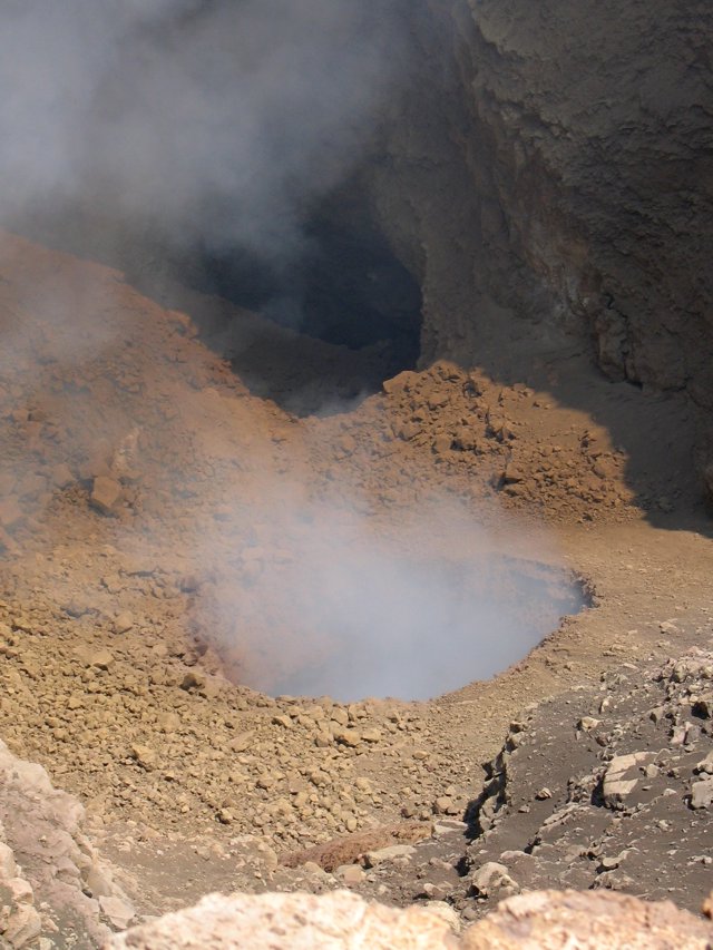 |
Figure 23. A photo taken from the second parking lot overlooking Masaya's Santiago Crater captured the scene at two vents within the inner crater on 10 March 2005. The younger, actively degassing vent and plume are in the foreground; the older, non-degassing vent is in the background. The latter vent was incandescent at night. The diameter of the active vent in this view is estimated to be 30-40 m. Courtesy of Patricia Nadeau and Glyn Williams-Jones. |
As of 10 March, the visible gas emissions were the lowest seen, despite the apparent open conduit, as indicated by incandescence in the old vent. Rumbling and sloshing sounds from within the crater had increased from sporadic to nearly constant. However, the days following were marked by a decrease in acoustical noise, as well as the apparent beginning of a climb back to higher SO2 emission rates (~ 120 tons/day on 16 March). These observations were consistent with devlopments in the upper conduit.
References. Williams-Jones, G., Horton, K. A., Elias, T., Garbeil, H., Mouginis-Mark, P. J., Sutton, A. J., and Harris, A. J. L., Accurately measuring volcanic plume velocity with multiple UV spectrometers: Bulletin of Volcanology, in press.
Williams-Jones, G., Delmelle, P., Baxter, P., Beaulieu, A., Burton, M., Garcia-Alvarez, J., Gaonac'h, H., Horrocks, L., Oppenheimer, C., Rymer, H., Rothery, D., St-Amand, K., Stix, J., Strauch, W., and van Wyk de Vries, B., (2001?), Projecto Laboratorio Geofisico-Geoquimico Volcán Masaya, Geochemical, geophysical, and petrological studies at Masaya volcano (1997-2000), on INETER website at.
Geological Summary. Masaya volcano in Nicaragua has erupted frequently since the time of the Spanish Conquistadors, when an active lava lake prompted attempts to extract the volcano's molten "gold" until it was found to be basalt rock upon cooling. It lies within the massive Pleistocene Las Sierras caldera and is itself a broad, 6 x 11 km basaltic caldera with steep-sided walls up to 300 m high. The caldera is filled on its NW end by more than a dozen vents that erupted along a circular, 4-km-diameter fracture system. The Nindirí and Masaya cones, the source of observed eruptions, were constructed at the southern end of the fracture system and contain multiple summit craters, including the currently active Santiago crater. A major basaltic Plinian tephra erupted from Masaya about 6,500 years ago. Recent lava flows cover much of the caldera floor and there is a lake at the far eastern end. A lava flow from the 1670 eruption overtopped the north caldera rim. Periods of long-term vigorous gas emission at roughly quarter-century intervals have caused health hazards and crop damage.
Information Contacts: Patricia Nadeau and Glyn Williams-Jones, Department of Earth Sciences, Simon Fraser University, Burnaby, Canada; Kirstie Simpson, Geological Survey of Canada, Vancouver, Canada; Washington Volcanic Ash Advisory Center (VAAC), Satellite Analysis Branch (SAB), NOAA/NESDIS E/SP23, NOAA Science Center Room 401, 5200 Auth Rd, Camp Springs, MD 20746, USA (URL: http://www.ospo.noaa.gov/Products/atmosphere/vaac/); Wilfried Strauch and Martha Navarro, Instituto Nicaraguense de Estudios Territoriales (INETER), Apartado Postal 2110, Managua, Nicaragua.