Report on Bulusan (Philippines) — May 2006

Bulletin of the Global Volcanism Network, vol. 31, no. 5 (May 2006)
Managing Editor: Richard Wunderman.
Bulusan (Philippines) Explosive activity continues
Please cite this report as:
Global Volcanism Program, 2006. Report on Bulusan (Philippines) (Wunderman, R., ed.). Bulletin of the Global Volcanism Network, 31:5. Smithsonian Institution. https://doi.org/10.5479/si.GVP.BGVN200605-273010
Bulusan
Philippines
12.769°N, 124.056°E; summit elev. 1535 m
All times are local (unless otherwise noted)
Bulusan erupted at 2258 on 21 March 2006, continuing into April 2006 (BGVN 31:04). Figure 2 shows the location of Bulusan volcano on the SE tip of Luzon. Figure 3 gives satellite measurements of SO2 one day after the eruption.
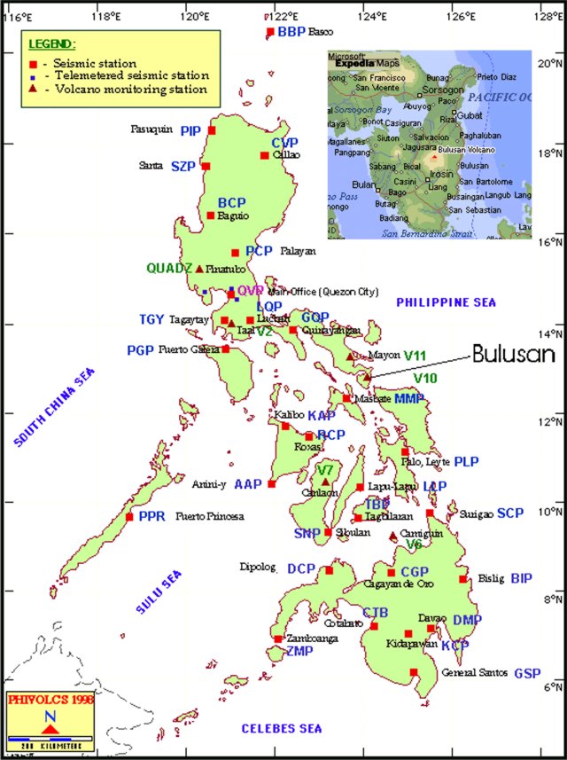 |
Figure 2. Map of the Philippines showing the PHIVOLCS earthquake and volcano monitoring network, and Bulusan's location. Smaller inset focuses on the Bulusan region and indicates some settlements. The smaller map is from Encarta Maps; the larger map, courtesy of PHIVOLCS. |
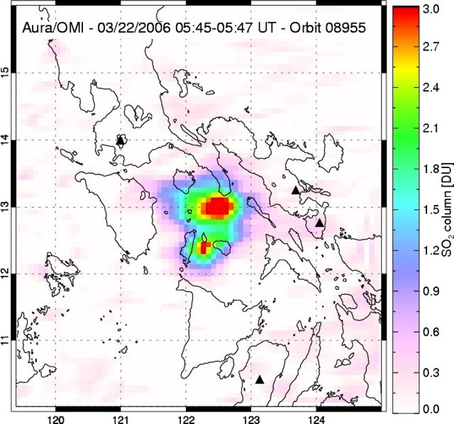 |
Figure 3. Sulfur dioxide (SO2) emissions at 1345-1347 (local) on 22 March 2006 from Bulusan. The eruption was measured by the Ozone Monitoring Instrument (OMI) on NASA's EOS/Aura satellite [OMI detects the total column amount of SO2 between the sensor and the Earth's surface]. This cloud appeared quite significant (estimated total mass ~ 1,000 metric tons) considering that the event was reported as phreatic and that the image was collected about 15 hours after the eruption. Courtesy of Simon Carn. |
An ash eruption on 29 April did not cause any damage, but authorities asked people to avoid the region near the crater (figure 4). The current report stems in large part from information coming from The Philippine Institute of Volcanology and Seismology (PHIVOLCS). Table 2 provides a brief summary of 2006 activity and resulting plumes.
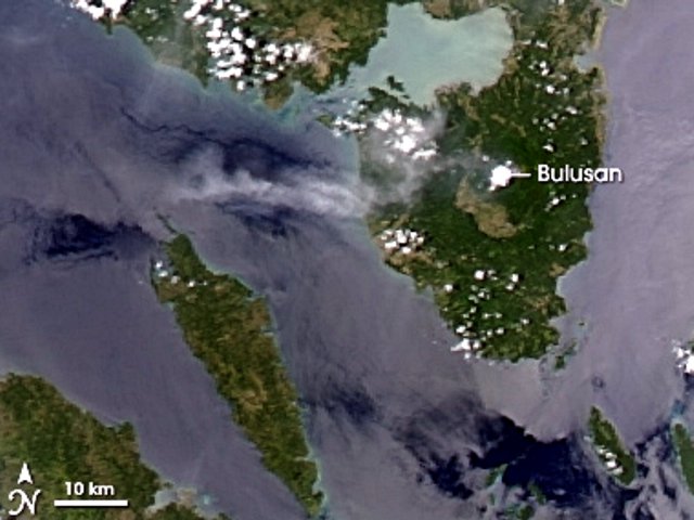 |
Figure 4. Image of a light ash plume snaking W from Bulusan acquired at 1250 on 29 April 2006. The image was made by the Moderate Resolution Imaging Spectroradiometer (MODIS) on the U.S. National Aeronautics and Space Administration (NASA) Terra satellite. Courtesy of NASA Earth Observatory. |
Table 2. Bulusan explosive plumes recorded during 2006. Courtesy of PHIVOLCS.
| Date | Local Time | Plume character | Plume height above summit | Direction(s) of plume drift |
| 21 Mar 2006 | 2258 | ash | 1.5 km | N, W, SW |
| 29 Apr 2006 | 1044 | ash | 1.5 km | WSW, NW |
| 25 May 2006 | 2117 | ash | -- | W, SW |
| 31 May 2006 | 1617 | ash/steam | 1.5 km | W, WNW |
| 07 Jun 2006 | 2017 | ash/steam | 2.0 km | N, W, SW |
| 10 Jun 2006 | 0018 | ash/steam | 1.0 km | N, NE |
| 13 Jun 2006 | 1904 | ash/steam | 1.5 km | NW |
| 18 Jun 2006 | 1556 | ash/steam | 1.5 km | W |
| 20 Jun 2006 | 2013 | cloud-covered summit | -- | -- |
| 28 Jun 2006 | 0206 | cloud-covered summit | -- | -- |
A phreatic ash explosion was recorded by the seismograph network at Bulusan between 2117 and 2130 on 25 May 2006. Light ashfall ranging from trace amounts to deposits 2 mm thick was reported from the W and SW villages of Bacolod, Sankayon, Puting Sapa, Rangas, Mapili, Caladgao, and Buraburan in the municipality of Juban, and Bolos in the municipality of Irosin, province of Sorsogon. PHIVOLCS reported that the ash explosion was more-or-less typical of activity at Bulusan during its current eruptive phase, and they expect more explosions to occur. Bulusan was at Alert Level 1, with a Permanent Danger Zone of 4 kilometers around the summit. The PHIVOLCS volcano alert signals range from Alert Level 1 (low-level unrest, no eruption imminent) through Alert Level 5 (hazardous explosive eruption in progress).
An ash-and-steam cloud emitted from the volcano on 31 May 2006 (figure 5) resulted in light ashfall, from trace amounts to 1.5 mm thickness, in areas W and NW of the volcano. An ash-and-steam cloud from Bulusan on 7 June 2006 resulted in light ashfall 5 km N and trace amounts as far as 20 km N. The Alert Level was raised to 2, which means restricted entry within 4 km of the summit. On 10 June, an ash-and-steam cloud reached a height of ~ 1 km above the summit and drifted N and NE. The Manila Standard Today reported one death caused by an asthma condition aggravated by exposure to ash.
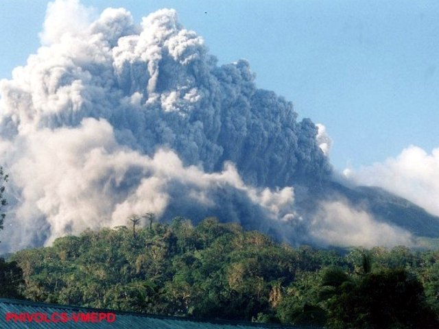 |
Figure 5. A Bulusan ash explosion seen at 1617 on 31 May 2006. The event was photographed from the foot of the volcano, 5- 6 km from the summit, in the town of Irosin. Courtesy of PHIVOLCS. |
On 13 June 2006 at 1904, an explosion lasting ~13 minutes issued from a fissure W of the summit vent of Bulusan. It produced an ash-and-steam cloud (table 2). Ashfall up to 7 mm thick accumulated at the foot of the volcano in neighborhoods in the municipality of Juban.
On 18 June at 1556 , an explosion lasted ~11 minutes; it produced an ash-and-steam cloud (figure 6). This was the 8th explosion since Bulusan reactivated in March. Ash up to 5 mm thick fell on a W-flank village.
 |
Figure 6. Mount Bulusan spews ash on 18 June 2006. Courtesy of Associated Press. |
On 20 June, a mild ash-and-steam explosion lasted approximately 17 minutes. The seismic network around the volcano recorded only one high frequency volcanic earthquake prior to the explosion. The ash and steam emission coincided with heavy rains that generated some lahars and torrential flows. The sulfur dioxide (SO2) emission rate that morning was 469 tons per day (t/d).
At 0800 on 26 June 2006, PHIVOLCS reported that the Bulusan seismic network had recorded four volcanic earthquakes during the past 24 hours. Steaming activity was wispy to moderate and reached an approximate height of 50 m above the summit before drifting WNW. On 28 June 2006, PHIVOLCS reported at 0800 that continuous seismic observation at Bulusan disclosed one small explosion-type earthquake and two volcanic earthquakes for the past 24 hours. The explosion occurred at 0206 on 28 June and lasted for about 4 minutes. However, the event was not observed because the summit was cloud covered all of 27 June until early in the morning of 28 June. No ashfall was reported following the explosion, and no lahar occurred at Gulang-gulang River in Cogon, Irosin. Sulfur dioxide (SO2) emission rates of the volcanic plume measured on 27 June decreased slightly, to 597 tons per day (t/d) in comparison to the 26 June 2006 rate of 942 t/d.
PHIVOLCS summarized the current 2006 activity as follows. In general, the character of explosions evolved only slightly, apparently becoming a little stronger later. The explosions in June were also somewhat longer in duration than earlier ash ejections, based on instrumental records and general visual monitoring. However, the absence of earthquakes, tremor, and generally low SO2 emission rates prior to each explosion suggested an absence of a large or active magmatic intrusion into shallow depths. Instead, they interpreted the sequence of explosions since March 2006 as pointing to interaction of small volumes of magma with an overlying water-saturated zone beneath the summit. These were thought to develop overpressures released during each explosion. It remains to be seen if the recent explosions would provide an "uncorking effect" and induce a major hazardous eruption. The very low earthquake activity was taken to suggests otherwise.
Geological Summary. Luzon's southernmost volcano, Bulusan, was constructed along the rim of the 11-km-diameter dacitic-to-rhyolitic Irosin caldera, which was formed about 36,000 years ago. It lies at the SE end of the Bicol volcanic arc occupying the peninsula of the same name that forms the elongated SE tip of Luzon. A broad, flat moat is located below the topographically prominent SW rim of Irosin caldera; the NE rim is buried by the andesitic complex. Bulusan is flanked by several other large intracaldera lava domes and cones, including the prominent Mount Jormajan lava dome on the SW flank and Sharp Peak to the NE. The summit is unvegetated and contains a 300-m-wide, 50-m-deep crater. Three small craters are located on the SE flank. Many moderate explosive eruptions have been recorded since the mid-19th century.
Information Contacts: Philippine Institute of Volcanology and Seismology (PHIVOLCS), PHIVOLCS Building, C.P. Garcia Avenue, U.P. Campus, Diliman, Quezon City, PHILIPPINES (URL: http://www.phivolcs.dost.gov.ph/); Earth Observatory, National Aeronautics and Space Administration (NASA) (URL: http://earthobservatory.nasa.gov/NaturalHarards/); The Manila Standard Today (URL: http://manilastandard.net/); Simon Carn, Joint Center for Earth Systems Technology (JCET), University of Maryland Baltimore County (UMBC), 1000 Hilltop Circle, Baltimore, MD 21250.