Report on Kama'ehuakanaloa (United States) — August 2006
Bulletin of the Global Volcanism Network, vol. 31, no. 8 (August 2006)
Managing Editor: Richard Wunderman.
Kama'ehuakanaloa (United States) Overview of ~8 years' seismicity; bathymetric images and submarine volcanology
Please cite this report as:
Global Volcanism Program, 2006. Report on Kama'ehuakanaloa (United States) (Wunderman, R., ed.). Bulletin of the Global Volcanism Network, 31:8. Smithsonian Institution. https://doi.org/10.5479/si.GVP.BGVN200608-332000
Kama'ehuakanaloa
United States
18.92°N, 155.27°W; summit elev. -975 m
All times are local (unless otherwise noted)
Our previous report (BGVN 26:09) discussed an earthquake swarm in September 2001; this report lists larger earthquakes near Lōʻihi during 1998-2006. In addition, it presents graphics depicting Lōʻihi morphology and makes reference to some recent research there.
An M 4.7 earthquake occurred with epicenter 24 km NW of Lōʻihi seamount at a focal depth of 40 km at about 1600 hours on 18 January 2006 (according to the U.S. Geological Survey (USGS) Earthquake Information Center (NEIC)). Such a depth would rule out the signal representing an eruption of the volcano. No damage occurred on land. Head scientist Jim Kauahikaua at the Hawaii Volcano Observatory (HVO) said the earthquake was felt as far as Pepeekeo, 16 km N of Hilo.
Table 1 gives a summary of earthquakes of M 4 or greater reported near Lōʻihi since 1998.
Table 1. Summary of earthquakes of M 4 or greater reported near Lōʻihi (within a radius of 25 km from the summit) during 1998 to September 2006. Magnitudes: mb = body wave, MD = duration (coda-length) magnitude, ML = local magnitude. Distance is from the center point of Lōʻihi (18.92°N, 155.27°W) to the epicenter. See BGVN 26:09 for additional details about the 11-13 September 2001 events. The events on 7 December 2005 are the three largest from a swarm of ~100 earthquakes. There were no earthquakes larger than M 4 during 1999-2000 or 2002-2004. Courtesy of USGS-NEIC.
| Date (UTC) | Origin time (UTC) | Latitude | Longitude | Depth (km) | Magnitude | Distance (km) |
| 27 Dec 1998 | 2140 | 18.79°N | 155.23°W | 10 | 4.70 MD | 14 |
| 21 Jul 2001 | 1801 | 18.91°N | 155.25°W | 13 | 4.10 MD | 2 |
| 11 Sep 2001 | 0009 | 18.85°N | 155.24°W | 12 | 4.90 mb | 7 |
| 13 Sep 2001 | 1311 | 18.86°N | 155.24°W | 12 | 5.20 mb | 7 |
| 13 Sep 2001 | 1839 | 18.87°N | 155.18°W | 12 | 4.40 mb | 10 |
| 08 Mar 2005 | 1726 | 19.01°N | 155.36°W | 18 | 4.20 mb | 13 |
| 23 Apr 2005 | 1301 | 18.80°N | 155.19°W | 44 | 4.30 ML | 15 |
| 13 May 2005 | 1006 | 18.87°N | 155.20°W | 44 | 5.10 MD | 9 |
| 17 Jul 2005 | 1915 | 18.78°N | 155.45°W | 32 | 5.4 MD | 24 |
| 07 Dec 2005 | 0902 | 18.92°N | 155.26°W | 13 | 4.00 mb | 0 |
| 07 Dec 2005 | 1142 | 18.92°N | 155.18°W | 28 | 4.70 MD | 9 |
| 07 Dec 2005 | 1158 | 18.87°N | 155.18°W | 12 | 4.00 MD | 10 |
| 19 Jan 2006 | 0204 | 19.05°N | 155.43°W | 40 | 4.70 MD | 22 |
From mid-July through August 1996, instruments had recorded a swarm of thousands of earthquakes (BGVN 21:07 and 21:09). For this period, 84 earthquakes of M 4 or greater were recorded; the largest event, M 4.9 MD, occurred at 0930 UTC on 28 July (2330 local time on 27 July). Observers in a submersible during a cruise from 6-10 August 1996 determined that the swarm was associated with the collapse of Lōʻihi's summit and an eruption (figure 10 and 11).
 |
Figure 10. Bathymetry of Lōʻihi seamount indicating the locations of Pele's Pit (the pit crater formed during the 1996 earthquake swarm) and Pisces Peak. To the N and NE of Pele's Pit are two older pit craters, West Pit and East Pit. Contour interval is 100 m; illumination is from the NE. From Caplan-Auerbach and Duennebier (2001). |
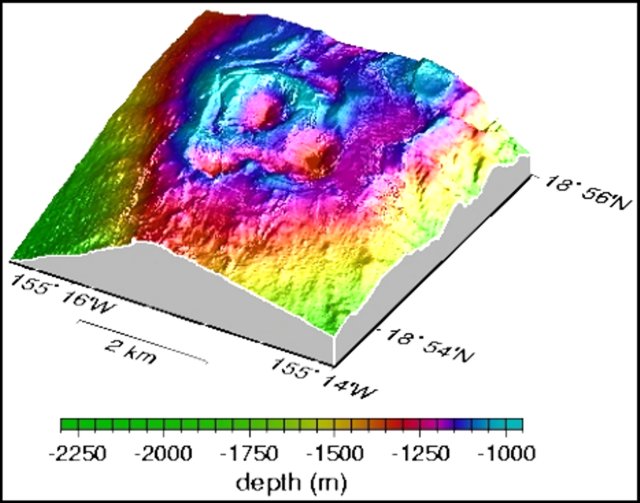 |
Figure 11. Three-dimensional bathymetric map of the southernmost two-thirds of the Lōʻihi summit platform. Courtesy of HVO web site. |
Investigators at the Monterey Bay Aquarium Research Institute (MBARI) have been studying Lōʻihi. When lava comes in contact with seawater, it cools so rapidly that it shatters into glass sand and rubble. When lava enters the sea under confined mixing conditions such as those within a lava tube, rapid expansion of seawater to steam in the tube can produce large basalt glass bubbles that shatter into curved, paper-thin, bubble-wall fragments known as "limu o Pele" (Pele's seaweed, figure 12). Such bubble-wall fragments and thin strands of volcanic glass, known as Pele's hair, have been recovered from Lōʻihi seamount and other deep-sea locations around Hawaii. Layered volcaniclastic deposits up to 11 m thick crop out along faults at the caldera's edge on Lōʻihi's summit. The layers include unconsolidated volcanic gravel, sand, silt, and mud. Fragments in volcaniclastic units include fluidal clasts, limu o Pele, highly vesicular to scoriaceous fragments, and Pele's hair (Clague and others, 2003; Clague and others, 2000).
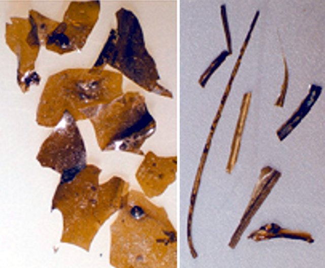 |
Figure 12. Fragments of limu o Pele (upper photo, largest diameters ~ 0.5 mm) and Pele's hair (lower photo, longest specimen is slightly over 1 cm), formed from lava bubbles during eruption (Clague, Davis, Bischoff, Dixon, and Geyer, 2000). Courtesy of MBARI, 2001. |
The high sulfur and carbon-dioxide contents of these basaltic glass shards suggest that they were erupted at great depth. These fragments indicate that submarine eruptions can be more violent than previously thought, and can produce features to depths of at least 4 km similar to those observed in shallow-water environments.
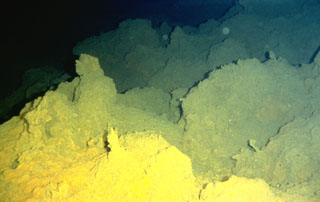
A December 2000 NOAA Research article (Malahoff, 2000) noted that "Three pit craters occupy the summit of Lōʻihi. The southernmost crater, Pele's Pit, formed during a two-week seismic swarm in 1996 that collapsed the hydrothermally active cone Pele's Vents. The new pit has steep walls with the floor located 200 meters below the rim of the crater. The crater floor and north slope are sites of spectacular and extensive hydrothermal venting with water temperatures ranging from 30°C to nearly 200°C. Diverse microbial mats surround the vents and cover the near vertical slopes of Pele's Pit."
New organisms identified at Lōʻihi include the bacteria, L2TR and Idiomarina loihiensis (a halophilic g-Proteobacterium (Donachie and others, 2003) and a shrimp, Opaepele loihi (Williams and Dobbs, 1995).
Embodying both the topic of limu o Pele and marine organisms, David Clague and colleagues at MBARI have identified foraminifera that incorporated volcanic bubble walls in their tests (figure 13). These were discussed on the MBARI website. "Benthic foraminifera often glue particles to their tests, perhaps for protection from predators. These particles may be sponge spicules, sand grains, or other detritus, depending on the materials available and the 'specialty' of the foram. In sediment cores from the Gorda Ridge, we found forams that 'specialized' in volcanic glass grains and others that 'specialized' in limu o Pele. They effectively concentrated the glass samples for us!"
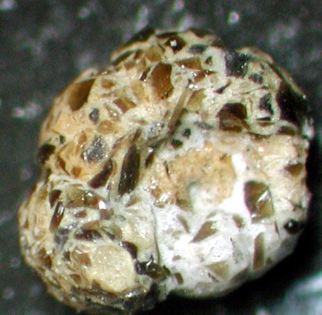 |
Figure 13. Benthic foraminifera with agglutinated limu o Pele (foram ~ 2 mm across). Image © MBARI 2003. |
References. Caplan-Auerbach, J., and Duennebier, F., 2001, Seismicity and velocity structure of Lōʻihi seamount from the 1996 earthquake swarm: Bulletin of the Seismological Society of America, v. 91, no. 2, p. 178-190.
Clague, D.A., Baiza, R., Head, J.W., III, and Davis, A.S., 2003, Pyroclastic and hydroclastic deposits on Lōʻihi Seamount, Hawaii, in Explosive Subaqueous Volcanism, White, J.D.L., Smellie, J.L., and Clague, D.A. (eds.): Geophysical Monograph 140, American Geophysical Union, p. 73-95.
Clague, D.A., Davis, A.S., Bischoff, J.L., Dixon, J.E., and Geyer, R., 2000, Lava bubble-wall fragments formed by submarine hydrovolcanic explosions on Lo'ihi Seamount and Kīlauea Volcano: Bulletin of Volcanology, v. 61, no. 7. p. 437-449.
Davis, A.S., Clague, D.A., Zierenberg, R.A., Wheat, C.G., and Cousens, B.L., 2003, Sulfide formation related to changes in the hydrothermal system on Lōʻihi Seamount, Hawai'i, following the seismic event in 1996: The Canadian Mineralogist, v. 41, p. 457-472.
Donachie, S.P., Shaobin, H., Todd, S.G., Malahoff, A., and Alam, M., 2003, Idiomarina loihiensis sp. nov., a halophilic ?-Proteobacterium from the Lo'ihi submarine volcano, Hawai'i: Int J Syst Evol Microbiol, v. 53, p. 1873-1879, DOI 10.1099/ijs.0.02701-0 (International Union of Microbiological Societies).
Malahoff, A., 2000, Lōʻihi submarine volcano: a natural extremeophile laboratory: U.S. Dept of Commerce, National Oceanic and Atmospheric Administration, Office of Oceanic and Atmospheric Research (http://www.oar.noaa.gov/spotlite/archive/spot_loihi.html), 12 October 2006.
Williams, A.B, and Dobbs, F.C, 1995, A new genus and species of caridean shrimp (Crustacea: Decapoda: Bresiliidae) from hydrothermal vents on Lōʻihi Seamount, Hawaii: Proceedings of the Biological Society of Washington, v. 108, p. 228-237.
Geological Summary. The Kama’ehuakanaloa seamount, previously known as Loihi, lies about 35 km off the SE coast of the island of Hawaii. This youngest volcano of the Hawaiian chain has an elongated morphology dominated by two curving rift zones extending north and south of the summit. The summit region contains a caldera about 3 x 4 km and exhibits numerous lava cones, the highest of which is about 975 m below the ocean surface. The summit platform also includes two well-defined pit craters, sediment-free glassy lava, and low-temperature hydrothermal venting. An arcuate chain of small cones on the western edge of the summit extends north and south of the pit craters and merges into the crests prominent rift zones. Seismicity indicates a magmatic system distinct from that of Kilauea. During 1996 a new pit crater formed at the summit, and lava flows were erupted. Continued volcanism is expected to eventually build a new island; time estimates for the summit to reach the ocean surface range from roughly 10,000 to 100,000 years.
Information Contacts: Hawaii Center for Volcanology, University of Hawaii at Manoa, Honolulu, HI (URL: http://www/soest.hawaii.edu/GG/HCV/loihi.html); U.S. Geological Survey Earthquake Information Center (NEIC) (URL: https://earthquake.usgs.gov/neis); Scripps Institution of Oceanography, Marine EM Laboratory (URL: http://marineemlab.ucsd.edu); Monterey Bay Aquarium Research Institute (MBARI), 7700 Sandholdt Road, Moss Landing, CA 95039-9664, USA (URL: http://www.mbari.org/); Hawaiian Volcano Observatory (HVO), U.S. Geological Survey, PO Box 51, Hawaii National Park, HI 96718, USA (URL: https://volcanoes.usgs.gov/observatories/hvo/); Alexander Malahoff, Institute of Geological and Nuclear Sciences Ltd. (GNS), Avalon, Lower Hutt, P.O. Box 30 368, New Zealand.