Report on Sulu Range (Papua New Guinea) — September 2006
Bulletin of the Global Volcanism Network, vol. 31, no. 9 (September 2006)
Managing Editor: Richard Wunderman.
Sulu Range (Papua New Guinea) Volcano seismicity declines in September and October 2006
Please cite this report as:
Global Volcanism Program, 2006. Report on Sulu Range (Papua New Guinea) (Wunderman, R., ed.). Bulletin of the Global Volcanism Network, 31:9. Smithsonian Institution. https://doi.org/10.5479/si.GVP.BGVN200609-252090
Sulu Range
Papua New Guinea
5.5°S, 150.942°E; summit elev. 610 m
All times are local (unless otherwise noted)
On 31 October 2006 the Rabaul Volcanological Observatory (RVO) issued a followup report to the eruptive activity in the Sulu Range through much of October. Sulu Range was previously discussed in BGVN 31:07, but that report was ambiguous on the nature of the activity that had taken place during July 2006. This report and personal communications establishes that RVO staff are doubtful that the most energetic events were magmatic in character. Furthermore, RVO reported that in the weeks that followed, seismicity continued to decline.
The seismic unrest that began on 6 July declined from over 2,000 daily volcano-tectonic (VT) events to below 50 daily VT events during October (figure 2). The number fluctuated between 35 and 50 from late September to early October and between 5 and 25 during the third week of October.
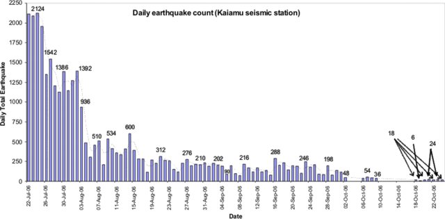 |
Figure 2. Sulu Range seismicity plot of daily VT earthquakes from 22 July 2006 to 24 October 2006 at the Kaiamu Seismic Station. The station did not operate on the days that lack earthquakes. Courtesy of RVO. |
RVO noted that about two to three felt earthquakes with intensity 2 continued to be felt daily at irregular intervals within the Bialla area and that white steam emissions from the Silanga Hot Springs were still visible from Bialla. In addition, a moderately strong sulfur smell from the Silanga and Talopu hot springs continued to be reported.
An analysis by RVO scientists concluded that at no point did magma reach the surface. The declining trend in seismic activity from early to late October may indicate that the new magma that apparently intruded to shallow levels in July is beginning to stall.
A permanent seismic station will be installed at Kaiamu in December 2006 to provide continuous monitoring of activity from the Sulu Range and surrounding areas.
In an extension of elevated regional tectonic seismicity, a strong earthquake, M ~ 6.5, struck the S side of central New Britain on 17 October. The USGS computed the focal depth as ~ 60 km, with epicenter ~ 50 km S of the Sulu Range. According to a USGS machine-generated shaking and intensity map, the Sulu Range lies within the zone of highest computed intensity (VI).
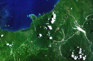
Geological Summary. The Sulu Range consists of a cluster of partially overlapping small stratovolcanoes and lava domes in north-central New Britain off Bangula Bay. The 610-m Mount Malopu at the southern end forms the high point of the basaltic-to-rhyolitic complex. Kaiamu maar forms a peninsula with a small lake extending about 1 km into Bangula Bay at the NW side of the Sulu Range. The Walo hydrothermal area, consisting of solfataras and mud pots, lies on the coastal plain west of the SW base of the Sulu Range. No historical eruptions are known from the Sulu Range, although some of the cones display a relatively undissected morphology. A vigorous new fumarolic vent opened in 2006, preceded by vegetation die-off, seismicity, and dust-producing landslides.
Information Contacts: Steve Saunders and Herman Patia, Rabaul Volcanological Observatory (RVO), Department of Mining, Private Mail Bag, Port Moresby Post Office, National Capitol District, Papua, New Guinea; USGS Earthquakes Hazard Program (URL: http://earthquakes.usgs.gov/)