Report on Montagu Island (United Kingdom) — September 2006
Bulletin of the Global Volcanism Network, vol. 31, no. 9 (September 2006)
Managing Editor: Richard Wunderman.
Montagu Island (United Kingdom) Five years of nearly persistent eruptive activity
Please cite this report as:
Global Volcanism Program, 2006. Report on Montagu Island (United Kingdom) (Wunderman, R., ed.). Bulletin of the Global Volcanism Network, 31:9. Smithsonian Institution. https://doi.org/10.5479/si.GVP.BGVN200609-390081
Montagu Island
United Kingdom
58.445°S, 26.374°W; summit elev. 1370 m
All times are local (unless otherwise noted)
Matthew Patrick reported that the month of October represents the 5-year anniversary of the start of the still-ongoing eruption at Mount Belinda on Montagu Island. The first satellite thermal alert for the volcano occurred on 20 October 2001, and was the first definitive record of historical volcanic activity on the island (BGVN 28:02) (Patrick and others, 2005). The MODVOLC monitoring system uses MODIS (Moderate Resolution Imaging Spectroradiometer) satellite data processed at the University of Hawai'i-Manoa. Current MODVOLC results, shown in figure 16A, indicate more-or-less persistent activity throughout the 5-year period, with radiant heat flux apparently peaking in late 2005 and early 2006.
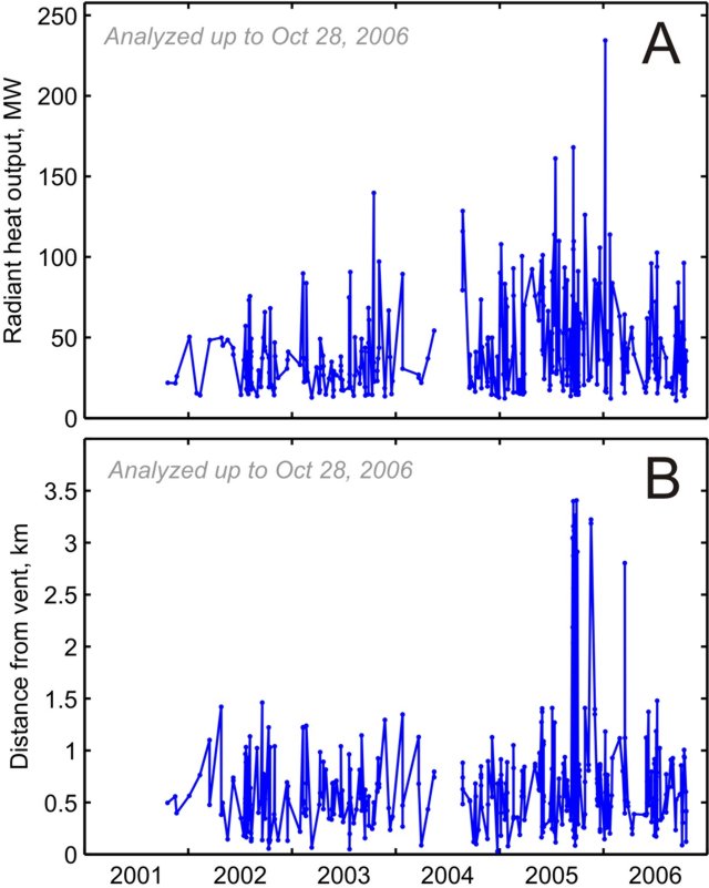 |
Figure 16. Plots of MODVOLC data at Belinda volcano on Montagu Island from 2001 to October 2006. (A) Chronological graph of radiant heat output from Mount Belinda measured from satellite sensors. (B) Chronological plot showing the distance of satellite-measured thermal anomaly pixels from the Mount Belinda vent. Courtesy of HIGP Thermal Alerts Team. |
Landsat and ASTER (Advanced Spaceborne Thermal Emission and Reflection Radiometer) imagery has shown that the eruption consisted of central vent activity producing lava flows. Small-scale explosive activity has also commonly blanketed the E side of the island. Three effusive events have been observed in ASTER/Landsat imagery, with the most recent (September-October 2005) producing a lava flow that traveled 3.5 km and reached the sea to build a 500-m-wide delta of lava (BGVN 30:09 and 30:11).
Figure 16B shows relative location (distance from the vent) comparing Mount Belinda's vent with the locations of MODVOLC alert pixels. This plot clearly shows longer flows during the September 2005 effusive event. Following this period, there were several other long-distance events. It is unclear if these reflect additional effusive events.
In addition, the first two effusive events observed in the ASTER/Landsat images do not appear on the MODVOLC plot (figure 16B), due either to cloud cover or their short flow lengths. Since the beginning of 2006, no cloud-free ASTER images have been available.
Geographic terminology. The nomenclature of volcanic features on Montagu Island, particularly in regard to Mount Belinda, has been quite variable. Although the name Montagu has been applied to the major volcanic edifice forming the island (LeMasurier and Thomson, 1990), the name Mount Belinda has been variously applied to the entire volcano, the currently active young cone on the northern side of the island, the 6-km-wide summit caldera, and a peak on the southern caldera rim that is the island's high point. In consultation with John Smellie of the British Antarctic Survey, we have used Montagu to refer to the volcano forming the island and Mount Belinda for the currently active cone.
References. LeMasurier, W.E., and Thomson, J.W. (eds.), 1990, Volcanoes of the Antarctic Plate and Southern Oceans: Washington, D C: American Geophysical Union, 487 p.
Patrick, M.R., Smellie, J.L., Harris, A.J.L., Wright, R., Dean, K., Izbekov, P., Garbeil, H., and Pilger, E., 2005, First recorded eruption of Mount Belinda volcano (Montagu Island), South Sandwich Islands, Bulletin of Volcanology, v. 67, no. 5, p. 415-422.
Geological Summary. The largest of the South Sandwich Islands, Montagu consists of a massive shield volcano cut by a 6-km-wide ice-filled summit caldera. The summit of the 11 x 15 km island rises about 3,000 m from the sea floor between Bristol and Saunders Islands. Around 90% of the island is ice-covered; glaciers extending to the sea typically form vertical ice cliffs. The name Mount Belinda has been applied both to the high point at the southern end of the summit caldera and to the young central cone. Mount Oceanite, an isolated peak at the SE tip of the island, was the source of lava flows exposed at Mathias Point and Allen Point. There was no record of Holocene activity until MODIS satellite data, beginning in late 2001, revealed thermal anomalies consistent with lava lake activity. Apparent plumes and single anomalous pixels were observed intermittently on AVHRR images from March 1995 to February 1998, possibly indicating earlier volcanic activity.
Information Contacts: Matthew Patrick, Dept. of Geological and Mining Engineering and Sciences, Michigan Technological University, 1400 Townsend Drive, Houghton, MI 49931, USA; HIGP MODIS Thermal Alert System, Hawai'i Institute of Geophysics and Planetology (HIGP), University of Hawaii at Manoa, 168 East-West Road, Post 602, Honolulu, HI 96822, USA (URL: http://modis.higp.hawaii.edu/); John Smellie, British Antarctic Survey, Natural Environment Research Council, High Cross, Madingly Road, Cambridge CB3 0ET, United Kingdom (URL: https://www.bas.ac.uk/).