Report on Home Reef (Tonga) — October 2006
Bulletin of the Global Volcanism Network, vol. 31, no. 10 (October 2006)
Managing Editor: Richard Wunderman.
Home Reef (Tonga) More details on the new island and drifting pumice rafts, including satellite data
Please cite this report as:
Global Volcanism Program, 2006. Report on Home Reef (Tonga) (Wunderman, R., ed.). Bulletin of the Global Volcanism Network, 31:10. Smithsonian Institution. https://doi.org/10.5479/si.GVP.BGVN200610-243080
Home Reef
Tonga
18.992°S, 174.775°W; summit elev. -10 m
All times are local (unless otherwise noted)
An eruption from Home Reef in early August generated large volumes of pumice that floated to Fiji (over 700 km away) in the following two months; an island was also created (BGVN 31:09). Satellite data and imagery have been used to confirm these observations and provide additional information about this event.
Norman Kuring of the MODIS Ocean Color Team identified the earliest clear shot of the pumice raft in a Terra MODIS on 7 August at 2120 UTC (8 August at 1020 Tonga time). The image (figure 11) shows a circular patch of pumice over the eruption site with a small volcanic plume emerging from it. The first indication of pumice raft leaving the eruption site is in the Aqua MODIS image at 0132 UTC on 10 August, but the 9 August overpass was cloudy, so it could have happened earlier. Kuring also compiled other images showing the dispersion of the pumice through 22 August (figure 12).
 |
Figure 11. Terra MODIS image taken on 8 August 2006 (local time) showing the early stages of the eruption at Home Reef. A steam plume is visible rising from the southern end of a mass of floating pumice covering an area larger than Late Island to the NW. Courtesy of the NASA Ocean Color Group. |
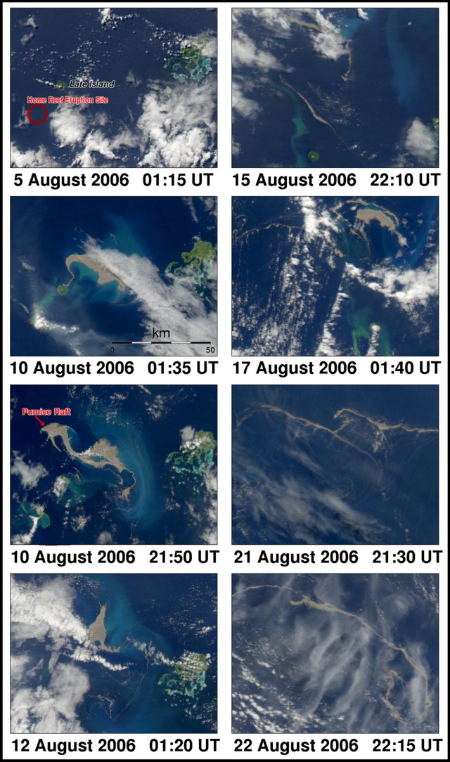 |
Figure 12. Terra and Aqua MODIS satellite images showing the dispersion of the pumice raft generated by the eruption at Home Reef during 7-8 August. By 10 August a large raft was NE of Late Island. Most of the material stayed in that area through 12 August before breaking up into elongate pieces that began moving W towards Fiji. Courtesy of the NASA Ocean Color Group. |
Kuring also made a preliminary estimate of the area of the pumice raft on 11 August (10 August at 2150 UTC), previously encountered by the Maiken (BGVN 31:09). A mask was created to cover identifiable areas of pumice, resulting in an area of 9,338 pixels. Each pixel in the image used covers an area of 0.0468 km2. The calculated total area is approximately 440 km2 for that time. Note that this estimate does not take into account errors caused by pumice being a high-contrast target (allowing linear patches less than the pixel width to be seen), small isolated patches of pumice that could not be recognized, material hidden by clouds, or fragments suspended in the water column under the surface. In the 8 August MODIS image, the circular area was determined by Bulletin editors to be at least 8 km in diameter, so the area covered was more than 50 km2.
Simon Carn (UMBC) used the Ozone Monitoring Instrument (OMI) on NASA's Aura satellite to constrain the timing of the eruption. OMI detected SO2 emissions from the vicinity of Home Reef beginning on 8 August. Emissions appear to have peaked sometime during 8-9 August. The total SO2 mass detected E of Tonga by OMI on 9 August was ~ 25 kilotons. By 12 August there were 3.3 kilotons of SO2 in the area (figure 13). The emission episode was over by 15 August. HYSPLIT forward trajectories indicated that the SO2 released on 8 August may have reached altitudes of 5 km or more. Carn also stated that "To our knowledge this is the first example of satellite detection of emissions from a submarine volcano. Significant scrubbing of SO2 and other soluble volcanic gases is likely during such events."
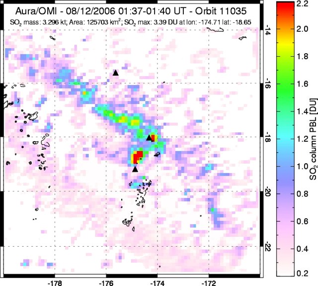 |
Figure 13. Sulfur-dioxide emissions in the vicinity of Home Reef, 12 August 2006 at 0140 UTC. Data obtained from the Ozone Monitoring Instrument (OMI) on NASA's Aura satellite. Courtesy of Simon Carn. |
Terra MODIS data from 4 September 2006 provided by Alain Bernard showed pumice rafts moving SE from Home Reef (figure 14). Pumice that previously followed a similar path was found on beaches in southern Vava'u (BGVN 31:09) by 2 September.
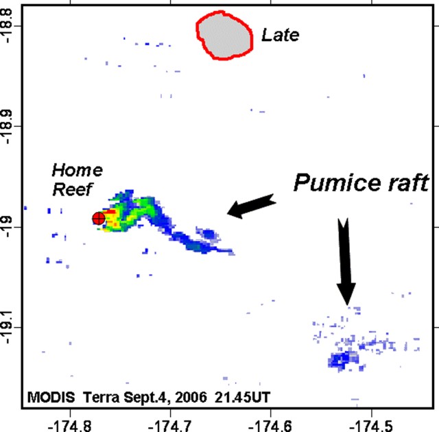 |
Figure 14. Terra MODIS data from 4 September 2006 showing pumice rafts moving SE from Home Reef. Data was obtained with a simple processing of bands 1 and 2; pixel size is 250 meters. Courtesy of Alain Bernard. |
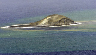
Island evolution. No data or reports are available to determine when the island built by the 1984 eruption (SEAN 09:02 and 09:04) eroded below the ocean surface. Recent reports from mariners and local fishermen noted that this current eruption had built a new island, implying the absence of an island at that location. An ASTER image inspected by Matt Patrick from 18 November 2005 did not show an island.
An ASTER image of the new island taken on 4 October 2006 (figure 15) has been studied by a number of scientists, including Greg Vaughan (JPL), Matt Patrick (Michigan Tech), and Alain Bernard (Univ. of Brussels). The image clearly shows the island (at 18.991°S, 174.762°W) with large ? and NE-directed anomalous areas that are likely caused by volcanic material suspended in the water. The new island is warmer than adjacent Late island. Greg Vaughan provided an annotated version of the image zoomed in on the new island, which he computed then had an area of 0.245 km2. Vaughan also noted that the "daytime image shows considerable activity in the water around the new Home Reef island [and] a thermal plume in the same shape as the pink colored area in the attached VNIR images (ASTER channels 3-2-1 as R-G-B)." Work by Alain Bernard based on the ASTER thermal bands determined that the hot lake on the island had a maximum temperature of 64.7°C on 4 October. Bernard calculated the island area to be 0.230 km2 on 4 October. Comparison with another ASTER image from 12 November showed that the island had changed shape and covered an area of 0.146 km2, a decrease of 0.084 km2 (figure 16).
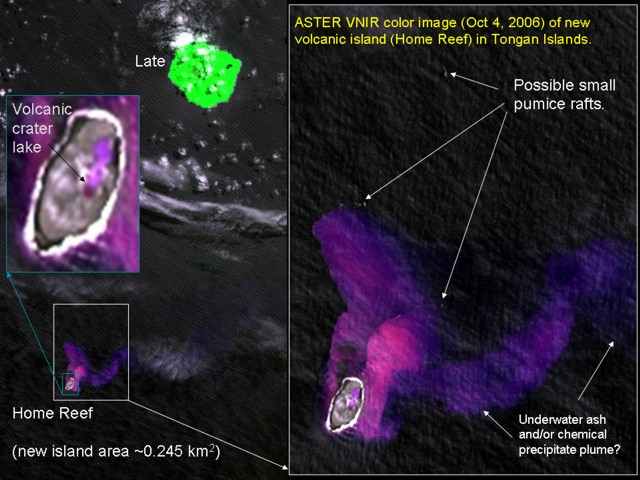 |
Figure 15. ASTER VNIR image showing the new island at Home Reef on 4 October 2006. A volcanic lake is visible on the island, as are submarine plumes originating from the island. Some possible small pumice rafts can also be identified in this 15-m imagery. Modified from original provided courtesy of Greg Vaughan. |
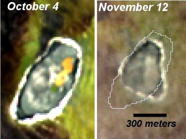 |
Figure 16. Comparison of the island at Home Reef on 4 October (left) and 12 November 2006 (right) using ASTER imagery. The size of the island decreased approximately 0.84 km2 over that time period. Courtesy of Alain Bernard. |
Floating pumice observations. Additional pumice sightings have been reported that supplement those described earlier (BGVN 31:09). Areas known to have been impacted by the pumice now include Suva Point (where the capital of Fiji, Suva, is located) and Yasawa Island (N of Viti Levu and E of Vanua Levu). By early November pumice from Home Reef had reached Efate Island in Vanuatu.
Crew on the SV Sandpiper encountered pumice during transit from Tonga to northern Fiji on 12 September. They went through "large patches" of pumice "all afternoon" while traveling about 200 km over the course of the day. The next evening, after sunset on 13 September, the boat suddenly slowed and the water "looked like a thick chocolate shake." Lights shining down from the rigging (spreader lights) showed that they were surrounded by pumice. The crew observed pumice again on 23 September at the southern end of Vanua Levu.
Wally Johnson was flying from Suva to Taveuni on 19 September and observed large amounts of pumice in the Koro Sea, drawn out into numerous parallel strings in the direction of the prevailing wind and heading towards Taveuni. A fair bit of the pumice had been washed up into ridges on beaches on the NW coast of Taveuni, and up and into pockets on some of the recent basaltic lava flows to the SW. Bernie Joyce forwarded additional reports from Fiji. On 27 October 2006, Rebekah Mue-Soko reported that the Suva Point area of Viti Levu was filled with pumice as of 27 October, and that it had appeared sometime before 8 October. About 6 November 2006 Lyn and Darcy Smith were on the Fijian island of Yasawa, N of Viti Levu, and reported "a heap of pumice on the beach" which apparently arrived during their one-week visit.
While pumice has persisted in Fiji, some reached Vanuatu. Sandrine Wallez reported pumice on the W coast of Efate Island during the night of 4-5 November. A deposit around 10 cm thick was observed along 40 km of coastline. The largest pumice fragments were the size of a tennis ball. Pumice was still on the beaches in early December (figure 17). Shane Cronin was in Vanuatu in early October when a new batch of fresh pumice washed up on northern Efate beaches. Pumice is commonly being deposited on beaches around Vanuatu, and local residents told Cronin that they thought it was coming from up around the Ambrym-Lopevi area. Douglas Charley (DGMWR - Vanuatu) recorded explosion earthquakes on a portable geophone from south Epi (BGVN 29:04) at the beginning of September.
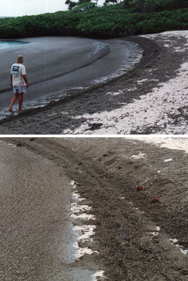 |
Figure 17. Photograph showing beach deposits of pumice from the August eruption at Home Reef on western Efate, Vanuatu, on 3 December 2006. Courtesy of Sandrine Wallez. |
Geological Summary. Home Reef, a submarine volcano midway between Metis Shoal and Late Island in the central Tonga islands, was first reported active in the mid-19th century, when an ephemeral island formed. An eruption in 1984 produced a 12-km-high eruption plume, large amounts of floating pumice, and an ephemeral 500 x 1,500 m island, with cliffs 30-50 m high that enclosed a water-filled crater. In 2006 an island-forming eruption produced widespread dacitic pumice rafts that drifted as far as Australia. Another island was built during a September-October 2022 eruption.
Information Contacts: Simon Carn, Joint Center for Earth Systems Technology, University of Maryland-Baltimore County (UMBC), 1000 Hilltop Circle, Baltimore, MD 21250, USA (URL: https://jcet.umbc.edu/); Norman Kuring, NASA/Goddard Space Flight Center, Code 970.2, Greenbelt, MD 20771, USA; Greg Vaughan, NASA Jet Propulsion Laboratory, California Institute of Technology, 4800 Oak Grove Dr., Pasadena, CA 91109-8099, USA; Alain Bernard, IAVCEI Commission on Volcanic Lakes (CVL), Université Libre de Bruxelles (ULB), CP160/02, avenue F.D. Roosevelt 50, Brussels, Belgium (URL: http://www.ulb.ac.be/sciences/cvl/homereef/homereef.html); Sandrine Wallez, Department of Geology, Mines, and Water Resources (DGMWR), Port-Vila, Vanuatu; R. Wally Johnson, 45 Alroy Circuit, Hawker, ACT 2614, Australia; Shane Cronin, Institute of Natural Resources, Massey University, Palmerston, New Zealand; Tom and Amy Larson, SV Sandpiper (URL: http://sandpiper38.blogspot.com/2006_09_01_sandpiper38_archive.html); E.B. Joyce, School of Earth Sciences, The University of Melbourne, VIC 3010, Australia (URL: http://earthsci.unimelb.edu.au/home).