Report on Likuruanga (Papua New Guinea) — October 2006

Bulletin of the Global Volcanism Network, vol. 31, no. 10 (October 2006)
Managing Editor: Richard Wunderman.
Likuruanga (Papua New Guinea) Tragic CO2-gas accident in open hole at inactive volcano
Please cite this report as:
Global Volcanism Program, 2006. Report on Likuruanga (Papua New Guinea) (Wunderman, R., ed.). Bulletin of the Global Volcanism Network, 31:10. Smithsonian Institution. https://doi.org/10.5479/si.GVP.BGVN200610-252804
Likuruanga
Papua New Guinea
4.953°S, 151.385°E; summit elev. 904 m
All times are local (unless otherwise noted)
Although Likuruanga volcano in West New Britain is thought to be of Pleistocene age (Johnson, 1971, 1970a, b), a boy died of carbon-dioxide (CO2) asphyxiation in a hole at Bakada village on the volcano's N flank on 21 September 2006. Details of the follow-up investigation came out in a report of the Rabaul Volcano Observatory (Mulina and Taranu, 2006). This report is a condensation of that work. The event serves as a reminder of threats from gas release in volcanic regions, even those areas in repose or unlikely to erupt again. In this case, the linkage to biogenic versus volcanogenic origins of the gas remains equivocal. Likuruanga's summit is ~ 13 km NNE of Ulawun's summit (figure 1). The volcano and Bakada village appear in several Google Earth images (figures 2 and 3).
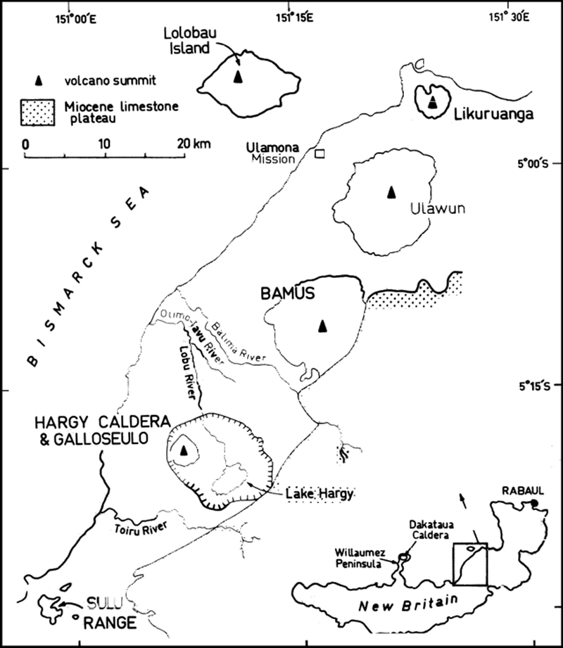 |
Figure 1. Likuruanga sits along the N coast of New Britain island (inset map). The larger figure comprises a sketch map of important features along the coast from Likuruanga to the Sulu Range. By far the most frequently active and reported-on volcano on the map is Ulawun, although recent reports have discussed unrest at both Bamus and the Sulu Range (BGVN 31:09) and regional seismicity has been high in 2006. This figure was scanned from Johnson (1970b) and modified. |
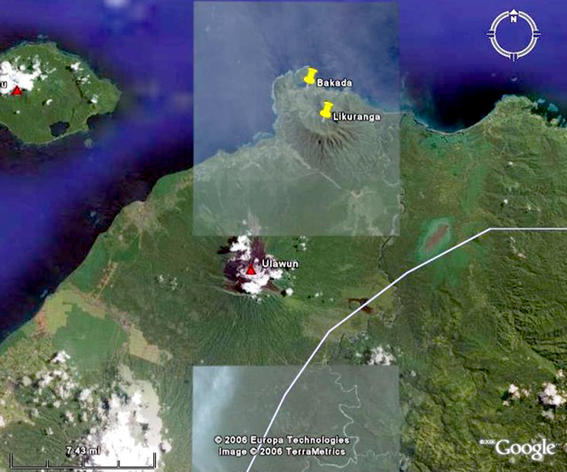 |
Figure 2. The coastal village Bakada on Likuruanga's N flanks. The village, which has few permanent residents but is used as a safe haven by nearby coastal villagers when Ulawun becomes restless. The linked line segments across the image crudely approximate the boundary between East and West New Britain. Courtesy of Google Earth. |
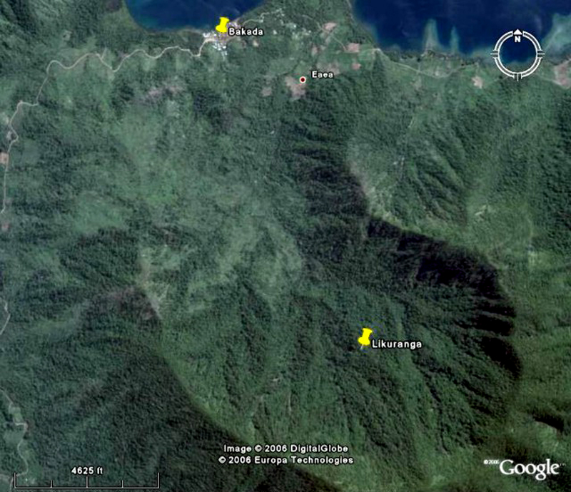 |
Figure 3. A closer view of Likuruanga's N-flank village Bakada. Courtesy of Google Earth. |
In 2004, a logging company dug a number of holes to build latrines but ceased after finding water at shallow depths. The company ultimately left the area without refilling the holes, which are behind some of the remaining buildings (figure 4). A conspicuous disturbed area corresponded with the reported coordinates of the hole on the zoomed-in image of the village ("hole," figure 4).
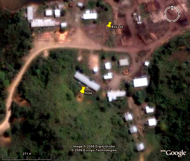 |
Figure 4. Although somewhat fuzzy, this zoomed-in view of Bakada shows the Likuruanga hole, which was labeled based on coordinates provided in the RVO report. Courtesy of Google Earth. |
Background on gas hazards. Natural sources of CO2 include volcanic outgassing, the combustion of organic matter, and the respiration processes of living aerobic organisms. CO2 gas is ~ 1.5 times heavier than air at the same temperature and can collect in depressions, and confined spaces such as caves and buildings. Without wind to ventilate an area, the denser CO2 displaces the typical atmosphere, causing an oxygen deficiency. For adult occupational exposure, one US agency recommends a ceiling limit of 3 percent CO2 for up to 10 minutes. Watanabe and Moritea (1998) studied responses of rats to various gases, including CO2. They discuss various types of asphyxia and the related diagnoses of causes of death.
Although the main component of volcanic gas is usually water vapor, other common volcanic gases can endanger life and property. These can include, as in this case, carbon dioxide (CO2); and, in an elevated temperature environment, a multitude of other gasses such as sulfur dioxide (SO2), hydrogen (H2), hydrogen sulfide (H2S), carbon monoxide (CO), and hydrogen fluoride (HF). The main dangers to health and life results from the effects of the acids and ammonia compounds on eyes and respiratory systems. The volcanic gases that pose the greatest potential hazard to people, animals, agriculture, and property are sulfur dioxide, carbon dioxide, and hydrogen fluoride.
Tragedy at Bakada village. On 21 September 2006, an 8-year-old boy, with his mother nearby, went down a large (2.6 m deep and 3.4 m wide) hole. He entered the hole trying to rescue his dog, which had fallen in. Witnesses recalled that the boy soon started shaking and screamed for help. A nearby woman went down the hole to rescue the boy and she, too, fell unconscious. Both were pulled from the hole by people at the rim with the aid of a long stick and knotted rope. The boy was dead; his hands a pale color. The woman was still breathing but vomited blood. She was rushed to a health center where she soon recovered. It was estimated that the woman was in the hole for 15 minutes and the boy somewhat longer (though this estimation remains crude as it could not be confirmed by anyone with a watch during the incident).
The following day, 22 September, villagers threw five small animals into the hole and noted that they all died immediately. The villagers also recalled that the previous year an employee of the logging company attempted to burn dried vegetation in the same hole and failed, even after adding waste diesel fuel to assist the process.
Investigation and conclusions. On 25 September RVO scientists arrived in Bakada to investigate the incident. It should be noted that for two days before their arrival there was moderate rainfall in the area. The scientists found that a frog and a dog were moving freely in the hole alongside the remains of the original five animals. The RVO report did not indicate when the frog and dog were put into the hole. In addition, a burning paper lowered into the hole continued to burn on the bottom surface.
On 27 September a return visit by RVO with instruments permitted the measurement of CO2 emissions from adjacent soil. The results listed in tables 1 and 2 show that the rate of CO2 emission varied, but generally increased as they approached the hole.
Table 1. Preliminary CO2 soil flux made with approach to the hole where the child died at Bakada village, Likuruanga volcano. The measurements were made ~ 6 days after the tragedy, on 27 September 2006. After Mulina and Taranu (2006).
| Duration (minutes) | Concentration of CO2 (ppm) over period of time (in minutes) as measured from varying distance away from the hole | ||||
| 1 m E | 5 m E | 100 m E | 100 m W | 250 m W | |
| Soil temp=28°C | Soil temp=28°C | Soil temp=27.2°C | Soil temp=29.5°C | Soil temp=27°C | |
| 0.0 | 2000 | 1380 | 1130 | 910 | 850 |
| 0.5 | 2200 | 1490 | 1140 | 930 | 860 |
| 1.0 | 2350 | 1530 | 1160 | 950 | 870 |
| 1.5 | 2400 | 1570 | 1190 | 980 | 900 |
| 2.0 | 2550 | 1700 | 1220 | 990 | 920 |
| 2.5 | 2725 | 1730 | 1250 | 1010 | 940 |
| 3.0 | -- | 1860 | 1290 | -- | 970 |
| 3.5 | -- | -- | -- | -- | 990 |
Table 2. Preliminary CO2 soil flux analyses at various distances from the hole; as measured on 27 September 2006. After Mulina and Taranu (2006).
| Distance from the hole | Soil CO2 flux (ppm per minute) | Soil CO2 flux (ppm per second) |
| 1 m | 270 | 5.4 |
| 5 m | 128 | 2.14 |
| 100 m E | 54.2 | 0.9 |
| 100 m W | 40.6 | 0.676 |
| 250 m W | 41.9 | 0.698 |
The investigators concluded that CO2 in the 2.6-m-deep hole caused the boy to die of asphyxiation and the woman attempting to rescue him to enter a semi-conscious state. It was also noted that whereas air currents may keep CO2 concentrations acceptably low on the land surface, the same does not hold true for deep holes. A final conclusion was that external factors such as rain may be able to wash out trapped CO2 from the air, but the continuing emission of the gas from the soil may lead to further accumulations during dry spells.
The authors recommended that the logging company refill all the holes and that knowledge of this tragedy be made more-widely known to cope with the dangers of toxic gases in volcanic areas. The authors also suggests that carbon isotopic analyses be carried out on the CO2 released at Bakada to determine if it is of magmatic or biogenic origin.
References. Johnson, R.W., 1971, Bamus Volcano, Lake Hargy Area, and Sulu Range, New Britain: Volcanic Geology and Petrology: Bur. Miner. Resour. Aust. Rec. 1971/55.
Johnson, R.W., 1970a, Ulawan Volcano, New Britain: geology,petrology and eruptive history between 1915 and 1967: Bur. Miner. Resour. Aust. Rec. 1970/21.
Johnson, R.W., 1970b, Likuruanga volcano, Lolobau Island, and associated volcanic centres, New Britain: geology and petrology: Bur. Miner. Resour. Aust. Rec. 1970/42.
Mulina, K., and Taranu, F., 2006, Gas related deaths at Bakada village inside Likuruanga volcano, West New Britain on 21st September 2006, report of Rabaul Volcano Observatory.
Watanabe, T. and Morita, M., 1998, Asphyxia due to oxygen deficiency by gaseous substances: Forensic Science International, v. 96, no. 1, p. 47-59.
Geological Summary. Likuruanga is a dissected, low stratovolcano with a large crater breached to the north. In September 2006, a boy died of carbon dioxide asphyxiation in a hole at Bakada village on the volcano's N flank.
Information Contacts: Rabaul Volcanological Observatory (RVO), Geohazards Management Division, Department of Mineral Policy and Geohazards Management (DMPGM), PO Box 3386, Kokopo, East New Britain Province, Papua New Guinea.