Report on Tungurahua (Ecuador) — December 2006

Bulletin of the Global Volcanism Network, vol. 31, no. 12 (December 2006)
Managing Editor: Richard Wunderman.
Tungurahua (Ecuador) Intense ongoing activity in 2006; new bulge on the N flank
Please cite this report as:
Global Volcanism Program, 2006. Report on Tungurahua (Ecuador) (Wunderman, R., ed.). Bulletin of the Global Volcanism Network, 31:12. Smithsonian Institution. https://doi.org/10.5479/si.GVP.BGVN200612-352080
Tungurahua
Ecuador
1.467°S, 78.442°W; summit elev. 5023 m
All times are local (unless otherwise noted)
According to the Instituto Geofísico-Escuela Politécnica Nacional (IG), Tungurahua, located 180 km S of the capital Quito, erupted on 14 July 2006 (BGVN 31:07), and again with great intensity in mid-August, resulting in at least five deaths. The 14 July event marked the beginning of a new energetic phase of activity different from that seen since October 1999. This report was taken from the IG's Special Reports and Bulletins (Numbers 7-15) discussing events from mid-July 2006 through early January 2007.
The new phase that began in July 2006 was characterized by highly explosive activity. It was associated with the arrival of a large volume of magma and the expulsion of hot, sometimes incandescent, pyroclastic flows. These flows traveled downslope with speeds of ~ 40 km/hour from the W, NW, and N flanks of the cone and ended at the Chambo river. The primary route of the flows was via the Achupashal, Cusua, La Hacienda, Juive Grande, Mandur, and Vascún gorges (see maps and figures in BGVN 31:07). Some of these flows were sufficiently large and mobile as to reach the Baños-Penipe road. The settlements of Cusúa, Bilbao, and to a lesser extent Juive Grande, were affected by these flows, which devastated pastures, fields, livestock, and basic infrastructure.
Additionally, small-volume pyroclastic flows descended the Vascún valley (upslope from the western part of Baños) but ended 2.5 km upstream from the hot springs of El Salado. The emission of hot incandescent pyroclastic flows ended one week after the explosive eruptions of 14-15 July.
Volcanic activity decreased significantly several weeks after 14 July, as shown by the seismic-based indicator developed for Tungurahua by the IG (figure 36). The daily indicator value decreased after mid-July and remained consistent until a slight increase during 8-13 August.
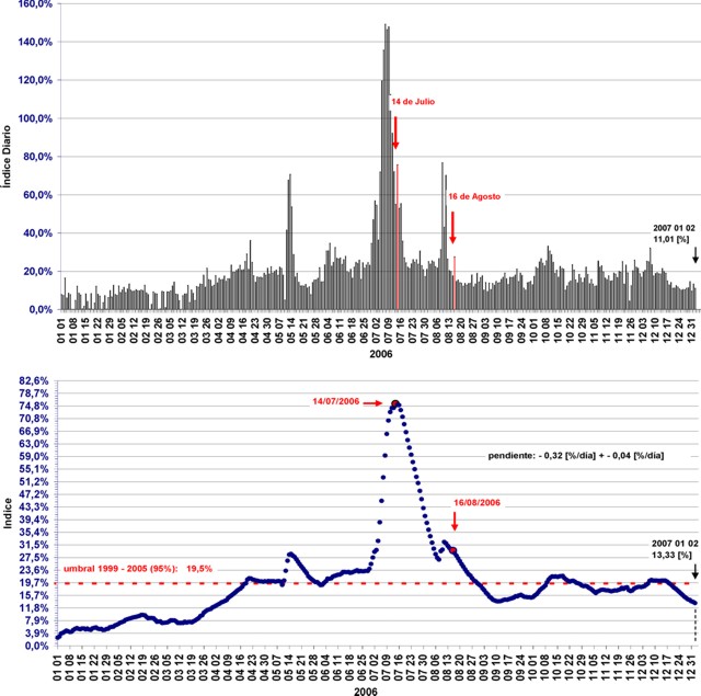 |
Figure 36. Index of daily seismic values (top) and index expressed in percentages (bottom) for Tungurahua from 1 January 2006 to 2 January 2007. Arrows mark the dates of the eruptions mentioned in this report. Courtesy of IG. |
On 1 August, a pyroclastic flow traveled W and SW down the flanks and reached the Rea gorge, where it left deposits an estimated 50 m thick consisting largely of blocks and ash. On 2 August, a small lahar traveled NW and blocked a highway. Strombolian activity was observed at night on 3 August. Small explosions were registered during 3-7 August. On 6 August, light ashfall was reported ~ 8 km SW in the town of Manzano.
During 9-15 August, small-to-moderate explosions produced plumes composed of gas, steam, and small amounts of ash that reached heights of ~ 1 km above the summit. Light ashfall was reported in nearby localities during 9-10 August. On 9 and 13 August, explosions expelled blocks of incandescent material that rolled 100 m down the W flank.
Bulge detected and intense explosive eruptions on 16 August. Clinometer measurements on 16 August indicated a bulge on the N flank as compared to 11 August. Seismic activity increased, as ash-and-gas plumes reached heights of 3 km above the summit and drifted W and NW. About 3,200 people were evacuated from "at-risk" areas. At 1900 on 16 August, a new, intense explosive eruption began that continued throughout the day. A large pyroclastic flow did not reach the road.
The eruption continued through 0145 on 17 August at high levels of intensity, ejecting incandescent rocks and generating pyroclastic flows. Several pyroclastic flows were reported in the Achupashal, Mandur y La Hacienda, Juive and Vascún ravines. On the 17th tephra fall (with pumice clasts ~ 3 cm in diameter) was reported from several areas in a wide zone that extended from Penipe in the SW to ~ 15 km NW. Ash plumes reached estimated heights of 10 km above the summit and covered the central part of Ecuador, forming a cloud ~ 742 km long and ~ 185 km wide trending NNW and SSE.
As of mid-August, about 20 pyroclastic flows had descended the above-mentioned ravines, and possibly others on the SW flank. At 2125 the largest pyroclastic flow of the sequence descended the Achupashal ravine and reached and dammed the Chambo river.
At 0033 on the 18th activity intensified, generating several pyroclastic flows and ashfall in several sectors from Penipe in the SW to the N; hot ashfall was reported in the villages of Pelileo, Cevallos, San Juan, and Cotaló. The large quantity of accumulated ash on roofs in the village of Pillate caused their collapse. The city of Baños lost electrical service. During this period, one of the pyroclastic flows descended near Juive Grande and crossed the Ambato-Baños. A sustained eruption column appeared incandescent and glowing at the base, with an associated ash cloud to 7 km above the crater that was blown W and SW. Continuous sprays and jets of lava rose hundreds of meters above the crater.
The explosive eruption on 16-17 August culminated around 0200 (figure 37), after which time the activity gradually decreased. The IG report stated that on 17 August, although the eruptive activity had ceased, longer lasting events including movement of magma and continuous deformation on the N flank indicated that residual magmatic fluid in the volcanic system was putting pressure on the structure. Additionally, emission of SO2 continued to be detected in moderate amounts. This report (Special Report ##14, 17 August 2006) also reminded authorities that the events of 1918 included five explosive eruptions interspersed with periods of reduced activity and that the entire W flank remained at risk of collapse, which could release a large volume of lava and produce much larger pyroclastic flows. Communities at most risk would be on the NW flank (Juive Grande, Los Pájaros, Cusua, Bilbao), but more distant zones at the bottom of the Chambo and Pastaza valleys (Chacauco, and eventually Puñapí) would also be affected.
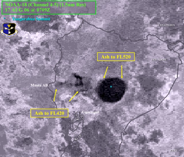 |
Figure 37. An interpreted satellite image of a tall Tungurahua eruption column. The satellite was NOAA-18 (Channel 4-5) (1.5 nautical mile resolution) at 0209 (0709 UTC) on 17 August 2006. Courtesy of the Air Force Weather Agency. |
Dramatic developments. On 18 August, incandescent blocks ejected from the summit descended ~ 1.7 km down the flank. Also that day, based on seismic interpretation, one of the blockages damming part of the Chambo River had been breached.
During 18-19 August, the N flank continued to inflate. During 20-21 August, steam emissions were observed during breaks in the cloud cover and the N flank exhibited deflation. On 23 August, two slow-moving lava flows were identified on the NW slope.
According to news reports, falling ash and debris caused fires and severe damage to five villages. An estimated 20,000 hectares of crops were destroyed. At least five people were dead or missing, and several more were injured. An estimated 4,000 people relocated to shelters.
Relative quiet, late August-October. During 23-27 August, visual observations of Tungurahua were impaired due to inclement weather. Based on seismic interpretation, lava continued to slowly flow NW towards Cusúa and La Hacienda. Seismicity was low and dominated by long-period earthquakes. Inclinometer measurements indicated no additional inflation on the flanks.
During September, seismicity remained low. On 1 September, lava flows on the NW flank were confirmed to have ceased. On 7 September lahars descended the NW gorges of Chontapamba and Mandur. During the month, there were several steam-and-gas plumes with little or no ash content. The emission heights ranged from ~ 0.1 to 2 km above the summit, and the primary wind drift was to the NW and W. Incandescence at the summit was observed at night. On the afternoon of 21 and on 22 September, moderate ash emissions occurred. Three more emissions on 23 September caused ashfall in Penipe; one plume rose 3 km and another 4 km above the summit. Ash plumes were seen again on 25 September.
No ash emissions were reported between 27 September and 2 October; however, on 2 October a slow-moving lava flow was seen descending the NNW flank and some fumarolic activity from the crater was observed. On 3 October an explosion resulted in ash falling in nearby communities to the W. According to the IG and aviation sources, the plume rose to at least 5 km above the summit.
During 4-5 October, Tungurahua's N flank fumaroles were active and steam emissions with minor ash content rose to 1 km above the summit and drifted W. Additional steam plumes possibly originated from the recent lava-flow's front. The IG again reported an increase in emissions and seismicity on 11 and 12 October, when steam plumes with slight to moderate amounts of ash reached 9-12 km altitude. Light ash fell in areas to the NW and W. During 13-17 October, seismicity decreased and plumes reached 7-8 km altitude.
On 16 October a small lava flow spalled off incandescent blocks; gas plumes were observed. Lahars traveled N toward Baños and down the Vazcún and Ulba gorges.
During 18-19 October, ash emissions increased in intensity and seismic tremor was continuous. During the night, lava fountains reached heights of 1 km above the crater rim and blocks rolled 800 m down the flanks. According to the Washington VAAC, around this time a pilot reported an ash plume to an altitude of 8.5 km. Ash plumes drifted NE and E and generated ashfall about 50 km E, in Puyo. According to news articles, about 300 villagers were evacuated.
Emissions continued during 20-24 October, producing plumes to 7-8 km. Ashfall was reported from towns on the N, NW, W, SW, and E flanks. On 28 October, incandescent blocks were expelled from the summit and rolled about 500 m down the W and E flanks. The next day, a lahar traveled NNW down the Mandur drainage and muddy water swelled in the Vazcún drainage. Incandescence from the crater was seen during most of October.
Ash plumes of steam and gas, and moderate ashfalls, were reported from several downwind towns on 5 and 6 November, including Bilbao (8 km W), Cotaló (13 km NW), and Manzano (8 km SW). On 2 November incandescent blocks were expelled from the summit and rolled 700 m down the W and E flanks. Nighttime incandescence was observed during 2-4 November.
On 7 November, a voluminous lahar traveled down gorges to the W and reached as far as the Chambo river, ~ 7 km from the summit. On 8 November, blocks expelled from the summit rolled down the flanks and ashfall was reported from areas including Casúa (7 km NW) and Baños (8 km NE). On 10, 11, and 13 November, ash fall was reported from areas including Penipe (8 km SW). During 12-13 November, lahars traveled down W and NW drainages and the Vazcún river swelled with muddy water.
On 17 November, an ash plume reached an altitude greater than 10 km and drifted NW and NE. During 26-27 November, Strombolian activity propelled incandescent material up to 600 m above the summit. Blocks rolled 2 km down the flanks. Lightning was visible in an ash plume that reached 7 km altitude and ashfall was reported from areas 8 km WSW. On 27 November, an ash plume rose to 9 km and drifted W. These conditions continued on into early December. On 6 December, plumes reached an altitude of 10 km. Ashfall was reported in areas including Cotaló, about 13 km NW, Pillate, about 7 km to the W, and Puela, about 8 km SW. On 9 December, ashfall up to 1 mm thick was reported about 12 km N in Baños.
Around this time seismicity was minimal in both intensity and duration. The plumes drifted in multiple directions. On 14 December, a lahar traveled SW down the Mapayacu gorge. On 21 December, lahars from Tungurahua traveled NW down the Mandur gorge resulting in a road closing and W down the Bilbao gorge. Gas-and-steam emissions produced small plumes on 22, 23, and 25 December. During 27 December-2 January, seismicity at Tungurahua remained moderate to low. On 27 and 28 December, lahars traveled down drainages including Bilbao to the W, Mandur to the NNW, and Mapayacu to the SW. During 3-9 January, seismicity at Tungurahua remained low to moderate.
Geological Summary. Tungurahua, a steep-sided andesitic-dacitic stratovolcano that towers more than 3 km above its northern base, is one of Ecuador's most active volcanoes. Three major edifices have been sequentially constructed since the mid-Pleistocene over a basement of metamorphic rocks. Tungurahua II was built within the past 14,000 years following the collapse of the initial edifice. Tungurahua II collapsed about 3,000 years ago and produced a large debris-avalanche deposit to the west. The modern glacier-capped stratovolcano (Tungurahua III) was constructed within the landslide scarp. Historical eruptions have all originated from the summit crater, accompanied by strong explosions and sometimes by pyroclastic flows and lava flows that reached populated areas at the volcano's base. Prior to a long-term eruption beginning in 1999 that caused the temporary evacuation of the city of Baños at the foot of the volcano, the last major eruption had occurred from 1916 to 1918, although minor activity continued until 1925.
Information Contacts: Geophysical Institute (IG), Escuela Politécnica Nacional, Apartado 17-01-2759, Quito, Ecuador (URL: http://www.igepn.edu.ec/); Washington Volcanic Ash Advisory Center (VAAC), Satellite Analysis Branch (SAB), NOAA/NESDIS E/SP23, NOAA Science Center Room 401, 5200 Auth Road, Camp Springs, MD 20746, USA (URL: http://www.ospo.noaa.gov/Products/atmosphere/vaac/); International Federation of Red Cross And Red Crescent Societies (IFRC) (URL: https://reliefweb.int/); Agence France-Presse (URL: http://www.afp.com/); Associated Press (URL: http://www.ap.org/).