Report on Talang (Indonesia) — January 2007
Bulletin of the Global Volcanism Network, vol. 32, no. 1 (January 2007)
Managing Editor: Richard Wunderman.
Talang (Indonesia) Short eruptive episode in April 2005; elevated activity in late 2006
Please cite this report as:
Global Volcanism Program, 2007. Report on Talang (Indonesia) (Wunderman, R., ed.). Bulletin of the Global Volcanism Network, 32:1. Smithsonian Institution. https://doi.org/10.5479/si.GVP.BGVN200701-261160
Talang
Indonesia
0.979°S, 100.681°E; summit elev. 2575 m
All times are local (unless otherwise noted)
Indonesian volcanologists with the Center of Volcanology and Geological Hazard Mitigation (CVGHM) (previously known by other names, including the Volcanological Survey of Indonesia) maintain an observation post and seismic network at Talang. After intermittent activity during September 2001 (BGVN 26:10) until June 2002 (BGVN 27:06), there was no additional reported activity until 2005 and 2006.
Activity during April 2005. On 12 April 2005 an eruption at Talang during 0340-0600 produced an ash plume that rose to ~ 1 km above the crater. About 4 mm of ash fell in the village of Bukit Sileh, NE of the crater. On the afternoon of 10 April observers had noted a "grey ash cloud" rising ~ 100 m, followed the next day by a diffuse white cloud around the summit. Volcanologist Dalipa, who heads the Batu Bajanjang observation post, told The Jakarta Post that there had been five large eruptions and hundreds of small eruptions before 1200 on 12 April that caused ashfall as far as 10 km away. He added that between the evening of 12 April and 0600 the next morning there were only six small eruptions.
An infrared image (GOES-9) taken at 0425 on 12 April 2005, analyzed by the Darwin VAAC, showed the eruption plume. There was a weak ash signature in the small cloud for a couple of hours before it became difficult to track. Plume height was estimated to be 7.5 km because the upper part of the cloud went NW, and winds below that were more or less westerly. The height of the cloud would have been difficult to see from the ground during the peak activity before dawn.
Simon Carn reported that the Ozone Monitoring Instrument (OMI) on EOS/Aura detected an SO2 plume from Talang on 12 April at 1402, and possible much weaker emissions on 13 April. The plume on 12 April extended roughly ESE towards central Sumatra, so was presumably at a lower elevation than the upper part of the ash cloud imaged earlier by the Darwin VAAC. The preliminary estimated SO2 mass was around 1,000 metric tons. Weak emissions were reported several days prior to the 12 April event, but OMI data only showed SO2 emissions from nearby Kerinci volcano.
A local government official told news media on 14 April that 25,150 residents from five villages in Lembang Jaya and Gunung Talang districts, located within a 5-km radius from the danger zone, had been evacuated. Winds were reportedly carrying ash downslope along with volcanic gases.
On 13 April volcanic and seismic activity decreased in comparison to the previous day. A "white-gray ash plume" rose 250 m from three points inside Kawah Mati crater, and white gas was emitted from Gabuo Atas crater. There was a decrease in the number of deep volcanic, shallow volcanic, and explosion earthquakes. By 0600 on 14 April the only reported activity was a diffuse "white ash" plume rising 250-300 m above the crater. However, news media quoting a government geologist reported that Talang "sent out fresh clouds of dust and continued to rumble" on 15 April.
By 17 April, activity had decreased and volcanologists lowered the hazard status to 3 (on a scale of 1-4). People were permitted to return their homes near the volcano, but no one could enter within 1 km of the summit. Due to a continued decrease in seismicity during 24-28 April (less than 10 volcanic events per day), the Alert Level was dropped to 2 on 28 April. Due to the hazards of minor phreatic eruptions, unstable land, and toxic gases, the area within a 1-km radius of the crater remained closed.
Activity during July 2005. Small phreatic eruptions occurred on 2 and 3 July 2005. The eruptions occurred at the main crater and a crater on the S slope. Ash columns reached 300-500 m above the volcano and caused 0.5-1 mm of ashfall around Kampung Batu, 2 km S of the summit. On the N slope, the Gabuo Atas, Gabuo Bawah, and Kapundan Panjang craters emitted "white-brown steam" to low altitudes. The temperature of Batu Bajanjang hotspring, located below the summit, was 41.9-61.3°C. The hazard status remained unchanged at Alert level 2 (on a scale of 1-4).
Increased seismicity on 18 July prompted an change in the Alert Level to 3. During 15-18 July, the seismic network recorded 93 deep volcanic earthquakes, one low-frequency tremor, and three "felt shocks" around the N slope of the crater. Minor phreatic activity occurred at the S and N slope craters, with dark gray ash plumes rising 0.5-1.5 km above the crater on 18 July.
Activity during September 2006. Increasing seismicity and gas emissions led to the hazard status being raised to Alert Level 3 on 9 September 2006. The next day "brownish smoke" was being emitted to heights of 250 m. The daily number of volcanic earthquakes and tremor fluctuated over the next few months, reaching a high of 33 events on 23 November. After that date seismicity showed a decreasing trend through late January 2007. Weak gas emissions continued during this period from both South Crater and Main Crater. Due to the lowered levels of activity, the hazards status was once again dropped to Alert Level 2 on 27 January.
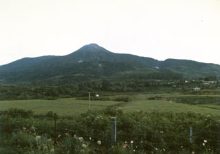
Geological Summary. Talang, which forms a twin volcano with the extinct Pasar Arbaa volcano, lies ESE of the major city of Padang and rises NW of Dibawah Lake. Talang has two crater lakes on its flanks; the largest of these is 1 x 2 km wide Danau Talang. The summit exhibits fumarolic activity, but which lacks a crater. Historical eruptions have mostly involved small-to-moderate explosive activity first documented in the 19th century that originated from a series of small craters in a valley on the upper NE flank.
Information Contacts: Center of Volcanology and Geological Hazard Mitigation, Diponegoro 57, Bandung, Jawa Barat 40122, Indonesia (URL: http://vsi.esdm.go.id/); Andrew Tupper, Darwin Volcanic Ash Advisory Centre, Bureau of Meteorology, Australia (URL: http://www.bom.gov.au/info/vaac/); Simon Carn, Joint Center for Earth Systems Technology (JCET), University of Maryland Baltimore County (UMBC), 1000 Hilltop Circle, Baltimore, MD 21250, USA; Agence France-Presse (AFP) (URL: http://www.afp.com/english/home/); Indahnesia.com (URL: http://news.indahnesia.com/); The Jakarta Post, Indonesia (URL: http://www.thejakartapost.com/); Associated Press (URL: http://www.ap.org/).