Report on Taal (Philippines) — January 2007

Bulletin of the Global Volcanism Network, vol. 32, no. 1 (January 2007)
Managing Editor: Richard Wunderman.
Taal (Philippines) Elevated seismicity, deformation, and hydrothermal activity during 2006
Please cite this report as:
Global Volcanism Program, 2007. Report on Taal (Philippines) (Wunderman, R., ed.). Bulletin of the Global Volcanism Network, 32:1. Smithsonian Institution. https://doi.org/10.5479/si.GVP.BGVN200701-273070
Taal
Philippines
14.0106°N, 120.9975°E; summit elev. 311 m
All times are local (unless otherwise noted)
On 26 September 2006, the Philippine Institute of Volcanology and Seismology (PHILVOLCS) announced ongoing seismic unrest at Taal (a low lying caldera ~ 45 km S of Manila). The Main Crater Seismic Station recorded 29 volcanic earthquakes during the 24 hours after 0600 on 25 September 2006. Five (5) of these occurred at 0233, 0234, 0242, 0247, and 0249 and were felt at Intensities II to III by residents on Volcano Island (figure 7 and 8). These earthquakes were accompanied by rumbling sounds. Initial computations showed epicenters generally dispersed toward northerly locations in the vicinity of Daang Kastila (NE), Tibag (N), Tablas (NE), Mataas na Gulod (NE), and Panikihan (NW).
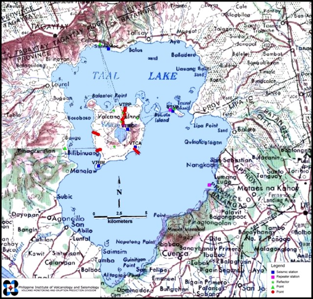 |
Figure 7. A map of Taal volcano indicating the location of components of the monitoring network (seismic stations, telemetry repeater stations, reflector, and various kinds of survey and measuring points). Volcano island (the large island in the N-central part of the caldera lake) is the site of all historical eruptions. Contour interval is 100 m. Courtesy of PHIVOLCS. |
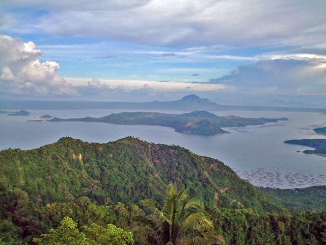 |
Figure 8. Photograph taken from the top of the N topographic margin of Taal, looking S across Lake Taal and Volcano Island, 28 May 2001. The topographic high on the far side of the lake is Mt. Macolod. Copyrighted photograph by Franck Landais (provided by Panoramio.com). |
This seismic activity was notably higher than usual, which during quiet periods is generally only five or less events detected in 24 hours. Surface thermal observations, however, did not indicate significant change in the thermal and steam emission manifestations in the Main Crater Lake area. The increase in seismicity reflected a low-level episode of unrest. However, there is still no indication of an impending eruption.
Taal manifested a sustained moderate level of seismic activity since 18 November 2006, characterized by occasional large amplitude volcanic earthquakes. During one 24-hour period, 10 volcanic earthquakes were detected. Ground deformation surveys conducted during 28 November-6 December 2006 revealed the edifice inflated 14.0 mm, suggesting possible magma intrusion. The Main Crater lake water became more acidic since 12 September 2006, and the newly formed mud geyser, which is now merged with the Crater Lake due to increase in water level, continues to be very active. The increasing acidity and hydrothermal activity are probably caused by the injection of hot gases and fluids coming from below the crater floor.
According to PHIVOLCS in its Taal Volcano Advisory of 14 December 2006, the above observations indicated a significant increase in activity although no eruption is imminent. Alert Level 1 continued, making the Main Crater off-limits to the public because of the chance of sudden steam explosions and high toxic gas concentrations.
Geological Summary. Taal is one of the most active volcanoes in the Philippines and has produced some powerful eruptions. The 15 x 20 km Talisay (Taal) caldera is largely filled by Lake Taal, whose 267 km2 surface lies only 3 m above sea level. The maximum depth of the lake is 160 m, with several submerged eruptive centers. The 5-km-wide Volcano Island in north-central Lake Taal is the location of all observed eruptions. The island is composed of coalescing small stratovolcanoes, tuff rings, and scoria cones. Powerful pyroclastic flows and surges have caused many fatalities.
Information Contacts: Philippine Institute of Volcanology and Seismology (PHIVOLCS), University of the Philippines Campus, Diliman, Quezon City, Philippines (URL: http://www.phivolcs.dost.gov.ph); Panoramio.com, Calle Rosa Zaragoza 8, 03360 Callosa de Segura (Alicante), Spain (URL: http://www.panoramio.com/photo/40914).