Report on Bulusan (Philippines) — April 2007

Bulletin of the Global Volcanism Network, vol. 32, no. 4 (April 2007)
Managing Editor: Richard Wunderman.
Bulusan (Philippines) Continued explosive eruptions and ashfall during October 2006 through May 2007
Please cite this report as:
Global Volcanism Program, 2007. Report on Bulusan (Philippines) (Wunderman, R., ed.). Bulletin of the Global Volcanism Network, 32:4. Smithsonian Institution. https://doi.org/10.5479/si.GVP.BGVN200704-273010
Bulusan
Philippines
12.769°N, 124.056°E; summit elev. 1535 m
All times are local (unless otherwise noted)
Activity declined at Bulusan in late June 2006 after a series of 10 explosions that began on 19 March 2006 (BGVN 31:09). Between 30 August and 1 September steam plumes reached up to 350 m above the summit; the plumes drifted NW and SE. This report summarizes Bulusan's activity from 10 October 2006 through 12 May 2007 (table 4). Hazard maps created by the Philippine Institute of Volcanology and Seismology (PHIVOLCS) illustrate the risks to the large numbers of cummunities in the vicinity of the volcano (figure 7). Review of the available MODIS data indicates no thermal alerts during the year prior to 31 May 2007.
Table 4. An overview of Bulusan's activity, as noted by PHIVOLCS during 10 October 2006 through 12 May 2007. Courtesy of PHIVOLCS.
| Date | Plume altitude | Drift direction(s) | Areas affected by ashfall or lahars | Remarks |
| 10 Oct 2006 | 3 km | SSW and SE | Irosin: San Benon, Sto. Domingo, and Patag, Bulusan: Bulusan Proper, San Roque, San Rafael, San Francisco, and Dangkalan. | Accompanied by rumbling sound. |
| 19 Oct 2006 | -- | -- | Irosin: Monbon, Gulang-Gulang, Cogon (traces of ash); Tinampo (0.5 mm thick ash). | Not observed, but recorded as explosion-type earthquake lasting for 2 minutes. |
| 23 Oct 2006 | 1 km | SE and SW | Irosin: Monbon and Tinampo (0.5 mm thick ash); Gulang-Gulang, and Tinampo (trace). | Accompanied by rumbling sounds. |
| 25-26 Oct 2006 | -- | -- | Irosin: Cogon (sediments 15 cm thick); Lahar (channel-confined muddy stream flow). | -- |
| 30 Oct 2006 | ~1 km | N and NW | Light ashfalls (trace to 1.0 mm): Casiguran: Inlagadian, San Juan, Casay, and Escuala; Gubat-Bentuco, Tugawe, Benguet, Rizal, Buenavista, Ariman, Tabi, Bulacao, Naagtan, Panganiban, Carriedo, and Gubat proper. | Series of three explosion explosion-type earthquakes lasting 35 minutes, accompanied by rumbling sounds. |
| 31 Oct 2006 | 0.7 km | N and NE | Casiguran: Inlagadian. | Small tremor that lasted for ~8 minutes. |
| 31 Oct 2006 | -- | -- | Irosin: Patag and Mapaso. | Not observed due to thick cloud cover; recorded as explosion type earthquake. |
| 21-28 Nov 2006 | -- | -- | -- | Seismic swarm - total of 170 events in three days; majority of epicenters more than 2 km away from the summit; 16-87 earthquakes daily. |
| 20 Dec 2006 | -- | -- | Irosin: ashfall at Monbon (1.5 mm), Buenavista (1.5 mm), Salvacion (2.5 mm), Casini (4.0 mm), Patag (trace), Santo (Sto.) Dmingo (trace), Tulay (3.0 mm), Poblacion (0.5 mm), and Bulan-Trece and Gate (trace). | Explosion-type earthquake for 20 minutes, accompanied by rumbling sound and lightning flashes. |
| 24 Jan 2007 | -- | -- | Traces of ash in Irosin: Cogon, Monbon, San Benon, Gulang-Gulang (including Sito Omagom) and Tinampo. | Explosion-type earthquake for 10 minutes. |
| 26 Jan 2007 | 1.0 km | SW | Irosin: Barangay Monbon. | Explosion-type earthquake lasting for 10 minutes. |
| Feb-Mar 2007 | -- | -- | Areas SW of the volcano. | Dirty white moderate to voluminous steam emission, no seismic record of ash explosion. |
| 07 Apr 2007 | -- | -- | -- | Increase in number of volcanic earthquakes; total of 68 events for two days. |
| 08 Apr 2007 | 4.0 | SW | Irosin: Mombon, Tinampo, Cogon, Gulang-Gulang (including Sitio Omagom), Bolos, and Sangkayon; Juban: Bura-buran and Bacolod; Magallanes: Siuton; Bulan: Cadandanan, Busay, Palale, San Francisco, and Sumagongsong. | Explosion-type earthquake for 27 minutes. |
| 09 Apr 2007 | -- | -- | -- | Not seen, but recorded as explosion-type earthquake lasting for 20 minutes, accompanied by rumbling sounds. |
| 09 Apr 2007 | -- | -- | -- | Not observed, but recorded as explosion-type earthquake for 20 minutes. |
| 17 Apr 2007 | -- | -- | -- | Increase in number of volcanic earthquakes; total of 35 events for 24 hours. |
| 12 May 2007 | 4.0 | WSW, WNW | Trace to 2 mm of ashfall. Irosin: Cogon, Gulang-Gulang, Tinampo, Bolos of Irosin. Juban: Bura-buran, Sangkayon, Bacolod, Puting Sapa, Aniog, and Sitio Cawayan (Bgy. Guruyan). | Event accompanied by rumbling sounds; recorded as explosion-type earthquake lasting for 35 minutes; elevated numbers of volcanic earthquakes. |
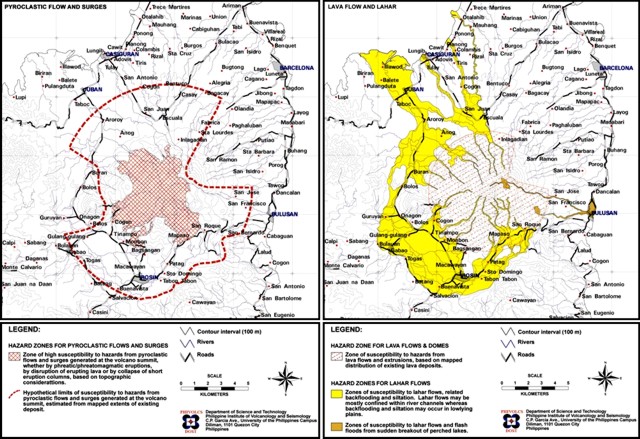 |
Figure 7. Hazards maps for Bulusan showing susceptibility to pyroclastic flows and surges (left), and lava flows and lahars (right). Courtesy of PHIVOLCS. |
PHIVOLCS reported an explosion from Bulusan on 10 October that produced an ash-and-steam plume that rose to 4.5 km altitude and drifted mainly SE and SSW. Light ashfall (1.5-5.0 mm thick) was reported in neighboring towns downwind. Based on seismic data, the activity lasted for 9 minutes. On 11 and 12 October, steam plumes drifted SW and SSW. Another explosion occurred on 19 October. The following day, steam plumes drifted W and WSW. On 23 October, an explosion produced a brownish ash plume that rose to about 2.6 km and drifted SE and SW. Light ashfall (trace to 0.5 mm thick) from the 19 and 23 Cctober explosions was reported from neighborhoods in the municipality of Irosin, about 7 km S of the summit.
During 25-26 October, PHIVOLCS reported a lahar that deposited sediments 15 cm thick along a tributary leading to the Gulang-gulang River. According to news articles, the lahar mobilized boulders as large as trucks and caused at least 96 people to evacuate. During 30-31 October, ash explosions generated a light gray ash-and-steam plume that rose to 2.3 km and drifted NNE. Later field inspection revealed ashfall (trace to 1 mm) N of the volcano, as well as in the municipalities of Casiguran and Gubat, about 12 km SSE and 18 km NNE, respectively, from the summit. Two explosion-type earthquakes recorded late on 31 October were followed by ashfall in Casiguran, Malapatan, and Irosin.
News articles and wire services reported that Bulusan emitted ash accompanied by rumbling noises and lightning flashes on 20 December. Clouds hindered a view of the summit. Ash deposits up to 4 mm thick were noted in several villages in the foothills. A news report in News Balita noted a plume of gas and "white ash" on 22 December.
In January 2007, PHIVOLCS reported that an explosion from the summit on 24 January lasted about 10 minutes, based on seismic interpretation. Observation was inhibited due to cloud cover. Ashfall was reported SW of the volcano.
On 15 March, news media reported that ash fell on Bulusan's SW slopes and nearby villages. A resident volcanologist stated that ashfall was caused by voluminous steaming during 12-15 March, not explosions. Other news articles stated that eruptions on 8 April produced ash plumes that rose to altitudes of 3.1-6.6 km.
PHIVOLCS reported another ash explosion on 12 May 2007 with an eruption column reaching a maximum height of 4 km above the summit before drifting to the WSW and WNW. The activity was accompanied by rumbling sounds and was recorded by the seismic network as an explosion type earthquake that lasted for about 35 minutes. Prior to the explosion, during 9-12 May, an increase in the daily number of volcanic earthquakes was noticed, with 42, 65 and 97 events recorded.
Geological Summary. Luzon's southernmost volcano, Bulusan, was constructed along the rim of the 11-km-diameter dacitic-to-rhyolitic Irosin caldera, which was formed about 36,000 years ago. It lies at the SE end of the Bicol volcanic arc occupying the peninsula of the same name that forms the elongated SE tip of Luzon. A broad, flat moat is located below the topographically prominent SW rim of Irosin caldera; the NE rim is buried by the andesitic complex. Bulusan is flanked by several other large intracaldera lava domes and cones, including the prominent Mount Jormajan lava dome on the SW flank and Sharp Peak to the NE. The summit is unvegetated and contains a 300-m-wide, 50-m-deep crater. Three small craters are located on the SE flank. Many moderate explosive eruptions have been recorded since the mid-19th century.
Information Contacts: Philippine Institute of Volcanology and Seismology (PHIVOLCS), University of the Philippines Campus, Diliman, Quezon City, Philippines (URL: http://www.phivolcs.dost.gov.ph); Tokyo Volcanic Ash Advisory Center, Tokyo, Japan (URL: http://www.jma.go.jp/jma/jma-eng/jma-center/vaac/index/html); Inquirer.net, Philippines (URL: http://www.inquirer.net/); Associated Press (URL: http://www.ap.org/); News Balita, Philippines (URL: http://news.balita.ph/).