Report on Aira (Japan) — April 2007

Bulletin of the Global Volcanism Network, vol. 32, no. 4 (April 2007)
Managing Editor: Richard Wunderman.
Aira (Japan) Eruption from E-slope Showa crater on 4 June 2007
Please cite this report as:
Global Volcanism Program, 2007. Report on Aira (Japan) (Wunderman, R., ed.). Bulletin of the Global Volcanism Network, 32:4. Smithsonian Institution. https://doi.org/10.5479/si.GVP.BGVN200704-282080
Aira
Japan
31.5772°N, 130.6589°E; summit elev. 1117 m
All times are local (unless otherwise noted)
According to the Sakurajima Volcano Research Center (SVRC) at Kyoto University, an eruption started on 4 June 2006 at the Showa crater, a spot that differs from vents active in recent decades at the summit of Minami-dake ("south mountain"; BGVN 31:06 and many previous reports). The Showa crater resides on the E slope of Minami-dake at an elevation of ~ 800 m (figures 23, 24, and 25). Showa crater was formed in a 1946 eruption; the 1946 vent was the source of lava flows that spread E and then branched to travel S and ENE (figure 25).
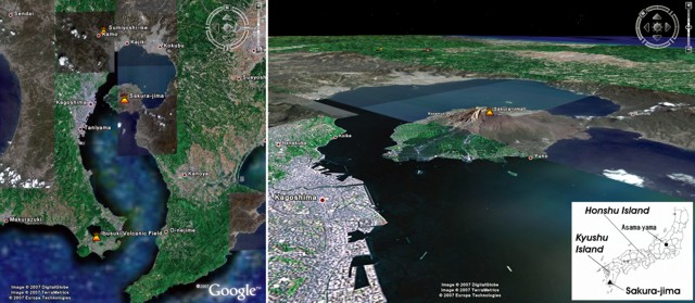 |
Figure 23. Map images showing Sakura-jima stratovolcano and environs on Japan's Kyushu island (~ 1,000 km S of Tokyo). (left) Image from Google Earth showing the S end of Kyushu Island. Population centers are labeled. Sakura-jima forms the dominant topographic feature in Kagoshima Bay. The Osumi Peninsula is to the E; the Satsuma Peninsula to the W. (right) Image from Google Earth showing terrain features looking NW towards the upper portions of Kagoshima Bay. Courtesy of Google Earth. |
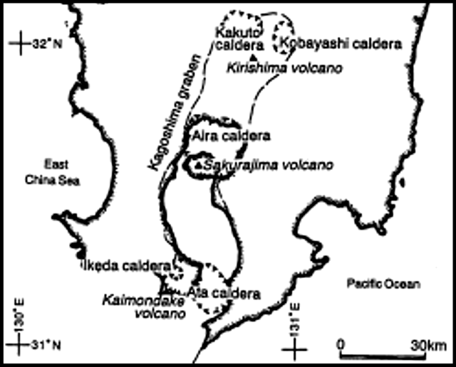 |
Figure 24. A sketch map focused on the geologic context of Sakura-jima, the Aira caldera, and adjacent calderas. The Kagoshima graben forms the Bay of the same name. The graben also lies coincident with several caldera margins. Sakura-jima resides at the S portion of Aira caldera. Modified slightly from Okuno and others (1998). |
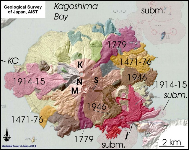 |
Figure 25. A geological map of Sakura-jima shown with several key features and eruptive dates labeled. Topographic highs from N to S include Kita-dake (K), Nika-dake (N), and Minami-dake (M). Craters at the summit of Minami-dake have been the active in past decades, but the eruption that started on 4 June eruption vented at Showa crater (S). An E flank lava flow (the Taisho Lava of 1914-1915) joined what had been an island's SE side to the shore (arrow at lower right labeled "j" aims at the zone of contact). Fringing the roughly circular former island are several areas of submarine volcanic and intrusive deposits (labeled here with the abbreviation "subm."). For example, the large area budding NE from the island consists of submarine and intrusive rocks of 1779-1780. Many of the Holocene eruptive deposits are dacites and andesites. They commonly bear pyroxene (and also sometimes, olivine). Besides lava flows, deposits include welded air-fall and pyroclastic-flow deposits (in some cases showing rheomorphosed textures indicative of movement downslope after forming a welded mass). From the Geologic Survey of Japan, AIST website (after Fukuyama and Ono, 1981 and Kobayashi, 1988). |
Unfortunately, at press time many details still remained unavailable to Bulletin editors regarding the duration and character of the return of venting at Showa crater. It is also unclear to what extent the Minami-dake summit craters continued to participate in the emissions.
The 4 June 2006 eruption continued intermittently, including an evening eruption on 7 June which sent an ash column ~ 1 km above the crater. Figure 26 shows one such eruption on 6 June.
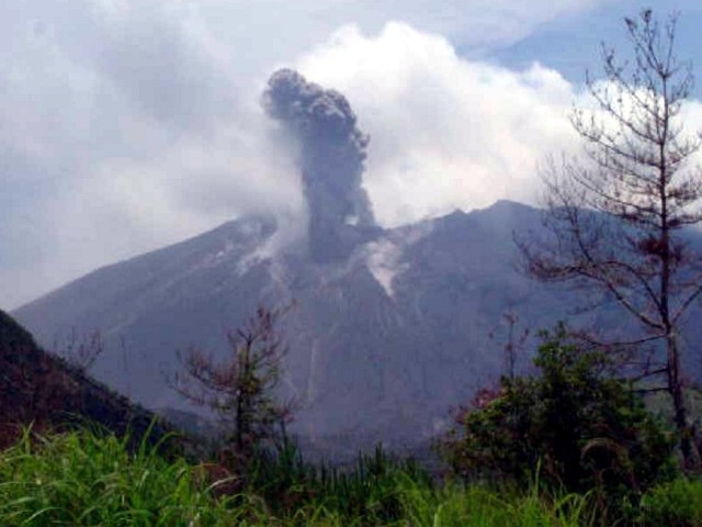 |
Figure 26. A photograph of Sakura-jima erupting at 1231 on 6 June 2006 from Showa crater. Courtesy of SVRC, Disaster Prevention Research Institute, Kyoto University. |
A series of plots describe the short- and long-term seismicity and volume of magma supplied at Sakura-jima (figures 27 and 28). The number of shallow earthquakes had increased since the middle of March 2006 (figures 26 and 27), and small volcanic tremors with a duration shorter than 2 minutes had increased since the middle of May 2006. GPS data showed continued inflation in the N part of the Aira caldera, an observation attributed to incoming magma. Kazuhiro Ishihara, director of SVRC, commented that the present eruption was considered to be related to magma accumulating in the Aira caldera and searching for an exit.
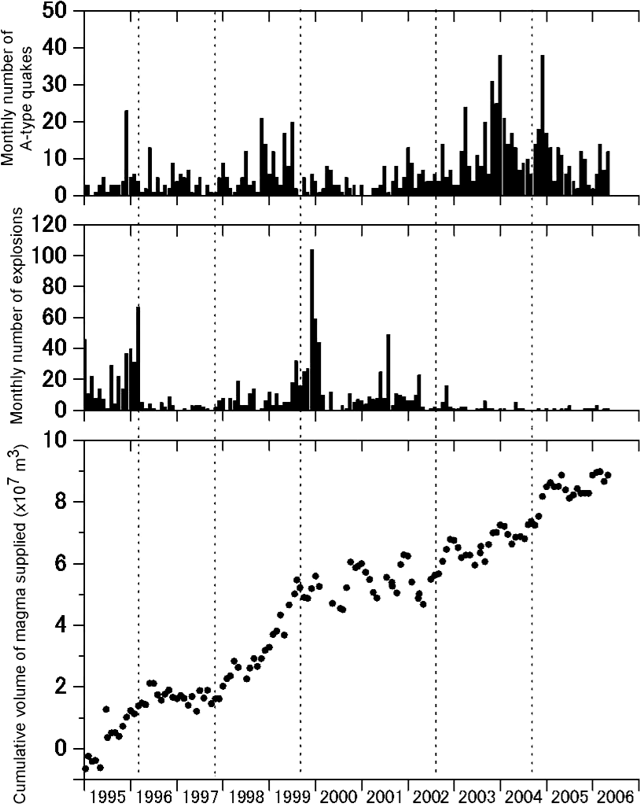 |
Figure 27. A multi-year (1995 to mid-2006) view of Sakura-jima's activity: (top) monthly A-type earthquakes, (middle) monthly number of explosions (determined geophysically, exact method undisclosed), and (bottom) the cumulative volume of magma supplied. Courtesy of SVRC, Disaster Prevention Research Institute, Kyoto University. |
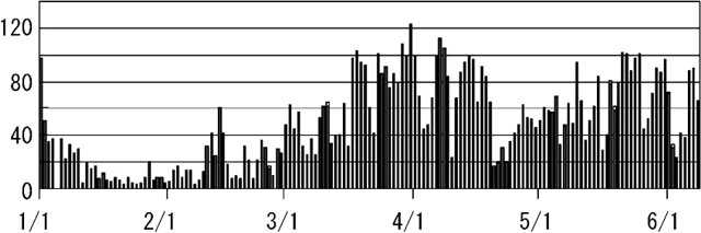 |
Figure 28. Plot of the daily number of volcanic earthquakes at Sakura-jima for the period 1 January-7 June 2006. Courtesy of SVRC, Disaster Prevention Research Institute, Kyoto University. |
Table 14 presents a chronology of ash-plume observations made since the previous Bulletin report (BGVN 31:06). The table is based primarily on reports from Tokyo Volcanic Ash Advisory Center (VAAC) and covers the interval 7 June 2006 to 20 March 2007. Most of the plumes described did not exceed 3 km altitude. The tallest plume recorded on the table, an ash plume on 20 March 2007, rose to 3.7 km altitude.
Table 14. Heights and drift of plumes and their character at Sakurajima from June 2006-March 2007. Some of the data during mid-June 2006 were previously reported, but new information has emerged. Courtesy of SVRC and Tokyo Volcanic Ash Advisory Center.
| Date | Plume altitude/drift | Other observations |
| 07-12 Jun 2006 | 3.4 km | -- |
| 10 Jun 2006 | -- | SVRC reported increase in low-frequency earthquakes since mid-March and in small tremors with a less than 2-minute duration since mid-May 2006; thermal anomaly at the volcano grew in size after February 2006. |
| 14, 16, 19 Jun 2006 | 2.1 km | -- |
| 02 Aug 2006 | 2.4 km/SW | explosion |
| 09 Aug 2006 | 2.4 km/straight up | eruption |
| 22, 23, 26 Aug 2006 | 2.4 km/SW | eruptions |
| 03-04 Sep 2006 | 2.7 km/NW and N | eruptions |
| 06 Sep 2006 | -- | explosion generated eruption cloud |
| 19 Sep 2006 | 3 km/straight up | eruption |
| 20, 21 Sep 2006 | 2.4 km | eruptions |
| 07, 08, 10 Oct 2006 | 1.8-2.4 km/W, S, and SW | eruptions |
| 21 Oct 2006 | 3.4 km/straight up | explosions |
| 25 and 27 Oct 2006 | 2.1-2.4 km/SW and NE | ash plumes |
| 04-05 Nov 2006 | 2.1-2.4 km/NE, SE, E | eruptions |
| 22 Nov 2006 | 2.1 km/W | explosions |
| 26 Nov 2006 | -- | eruption |
| 12 Dec 2006 | 2.1 km/NE | eruption |
| 13 Dec 2006 | -- | explosion |
| 02 Jan 2007 | 3.4 km/SW | eruption |
| 10 Feb 2007 | -- | explosion |
| 13 Feb 2007 | 2.1 km | explosion |
| 15 Feb 2007 | 1.5 km | ash plume |
| 20 Mar 2007 | 3.7 km | ash plume |
Volcanic hazards research. Lee and others (2005) reported the successful remote measurement of significant amounts of ClO (as well as BrO and SO2) in a volcanic plume from Sakura-jima during May 2004. Near the volcano they also observed halogen-catalyzed, local surface ozone depletion. The investigators employed ground-based, multi-axis, differential optical absorption spectroscopy. Their results help document the presence of a wide range of chemical species that have potential health implications for populations living nearby.
The center of Kagoshima City (population ~ 550,000) sits ~ 10 km from Minami-dake's summit and ~ 4 km from Sakura-jima's E shore (just off figure 24, but along the trend of the arrow labeled KC). According to Durand and others (2001), "Since 1955 the city has been subjected to ashfall from Sakura-jima. Until 1990 ashfalls occurred up to twice per week, although this has decreased in frequency in recent years."
Durand and others (2001) comment that "[Kagoshima City] presents a good opportunity to study the impacts of volcanic ash on key services, or 'lifelines.' In addition, the city provides a chance to see how lifelines have been adapted to counter any problems presented by ashfalls." They also noted that, "The advice from Kagoshima would seem to be that during an ashfall event, people should bring in the washing and shut the doors and windows. People who have to go out and work in ashfall should wear goggles and a face mask. In Kagoshima, umbrellas are the only form of protection for many people going to work during ashfall events."
References. Durand, M.; Gordon, K .; Johnston, D. ; Lorden, R. ; Poirot ,T. ; Scott, J. ; and Shephard, B.; 2001; Impacts of, and responses to ashfall in Kagoshima from Sakurajima Volcano?lessons for New Zealand. Science report 2001/30, Institute of Geological & Nuclear Sciences; Lower Hutt, New Zealand, November 2001 53p. (ISSN 1171-9184, ISBN 0-478-09748-4).
Fukuyama, H. and Ono, K., 1981, Geological Map of Sakura-jima, scale 1:25,000
Kobayashi, Tetsuo, 1988, Geological Map of Sakurajima Volcano, A Guidebook for Sakura-jima Volcano, in Kagoshima International Conference on Volcanoes, 1988 (1:50,000).
Lee, C., Kim, Y. J., Tanimoto, H., Bobrowski, N., Platt, U., Mori, T., Yamamoto, K., and Hong, C. S., 2005, High ClO and ozone depletion observed in the plume of Sakurajima volcano, Japan, Geophysical Research Letters, v. 32, L21809, doi:10.1029/2005GL023785.
Okuno, Mitsuru; Nakamura, Toshio, and Kobayashi, Tetsuo, 1998, AMS 14C dating of historic eruptions of the Kirishima, Sakura-jima and Kaimon-dake volcanoes, Southern Kyushu, Japan. Proceedings of the 16th International 14C Conference, edited by W. G. Mook and van der Plicht, RADIOCARBON, Vol. 40, No. 2, 1998, P. 825,832.
Geological Summary. The Aira caldera in the northern half of Kagoshima Bay contains the post-caldera Sakurajima volcano, one of Japan's most active. Eruption of the voluminous Ito pyroclastic flow accompanied formation of the 17 x 23 km caldera about 22,000 years ago. The smaller Wakamiko caldera was formed during the early Holocene in the NE corner of the caldera, along with several post-caldera cones. The construction of Sakurajima began about 13,000 years ago on the southern rim and built an island that was joined to the Osumi Peninsula during the major explosive and effusive eruption of 1914. Activity at the Kitadake summit cone ended about 4,850 years ago, after which eruptions took place at Minamidake. Frequent eruptions since the 8th century have deposited ash on the city of Kagoshima, located across Kagoshima Bay only 8 km from the summit. The largest recorded eruption took place during 1471-76.
Information Contacts: Sakura-jima Volcano Research Center, Disaster Prevention Research Institute (DPRI), Kyoto University, Gokasho, Uji, Kyoto 611-0011, Japan (URL: http://www.dpri.kyoto-u.ac.jp/~kazan/default_e.html); Tokyo Volcanic Ash Advisory Center (VAAC), Japan Meteorological Agency (JMA) (URL: http://ds.data.jma.go.jp/svd/vaac/data/).