Report on Popocatepetl (Mexico) — April 2007

Bulletin of the Global Volcanism Network, vol. 32, no. 4 (April 2007)
Managing Editor: Richard Wunderman.
Popocatepetl (Mexico) Minor explosions and lava dome growth
Please cite this report as:
Global Volcanism Program, 2007. Report on Popocatepetl (Mexico) (Wunderman, R., ed.). Bulletin of the Global Volcanism Network, 32:4. Smithsonian Institution. https://doi.org/10.5479/si.GVP.BGVN200704-341090
Popocatepetl
Mexico
19.023°N, 98.622°W; summit elev. 5393 m
All times are local (unless otherwise noted)
Centro Nacional de Prevencion de Desastres (CENAPRED) reported only sporadic, modest activity at Popocatépetl during early 2006 through April 2007. Based on information from the Mexico City Meteorological Watch Office (MWO), and the Washington Volcanic Ash Advisory Center (VAAC), there were five occasions when ash plumes rose substantially. On 25 and 27 July 2006 ash plumes rose to an altitude of ~ 9.8 km. On 18 and 20 December 2006, ash plumes rose to an altitude of ~ 6.7 km and 7.9 km, respectively. In April 2007, ash plumes rose to ~ 7.6 km on the 1st, and to ~ 7.3 km on the 3rd.
In August 2006, the lava dome that had been irregularly growing since July 2005 covered the floor of the internal crater and began a piston-like growth on the top of the previous dome. The enlarged dome can be seen in an aerial photography taken in 24 November 2006 (figure 51). This formation of the dome was the twenty-sixth such event since 1996.
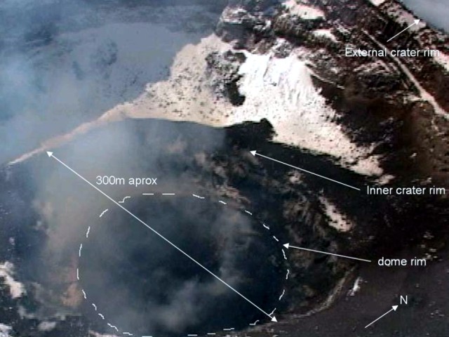 |
Figure 51. Aerial photo taken 24 November 2006 showing the growing lava dome at Popocatépetl.The dashed white line defines the dome edge. The lava dome that started growing in July 2005 has covered the floor of the internal crater and began growing on the top of the previous dome. The white areas outside the inner-crater rim are snow cover. Courtesy of the government of the State of Puebla, Mexico. |
On 4-5 August and 1-3 November 2006 episodes of large-amplitude harmonic tremor (figure 52) were believed to reflect an increased rate of dome growth. The accumulated volume of the lava dome between November of 2005 and November of 2006 was estimated to be 1,299,000 m3. The average rate growth over that interval is around 0.04 m?/s. Assuming that the dome grows only during the tremor episodes, the rate would be ~ 6.75 m3/s.
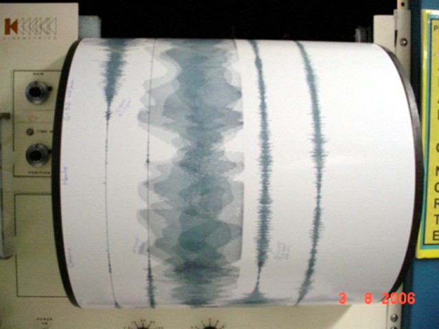 |
Figure 52. Evidence of a large-amplitude, multiband harmonic tremor, showing clear frequency peaks in its spectrum detected in August 2006 at Popocatépetl. The combination of the frequencies appear as moiré shadows in the paper recording.Courtesy of CENAPRED. |
Incandescence at the summit was recorded by the CENAPRED camera on 3 August and 4-5 September 2006. Over 27-29 October 2006, eigth small explosions ejected incandescent debris on the slopes surrounding the crater. During November and December 2006, more episodes of low amplitude tremors were recorded. From August to December 2006, 77 volcano-tectonic micro-earthquakes were detected, with magnitudes ranging between 2.0 and 3.0. From these, 66 were located below the crater at depths ranging between 3 and 7 km (figure 53).
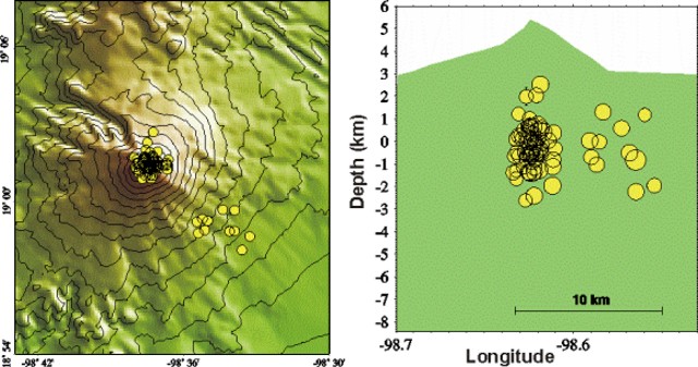 |
Figure 53. Location and depth of micro-earthquakes on Popocatépetl recorded during August to December 2006. Courtesy of CENAPRED. |
Hot spots at the summit were detected on satellite imagery by the Washington Volcanic Ash Advisory Center (VAAC) on 7-8 January 2007. According to the Washington VAAC, a puff with little ash content emitted from Popocatépetl was reported from the MWO and visible from the camera operated by CENEPRED on 14 February 2007. A very diffuse plume was seen drifting to the E on satellite imagery. Base on an aerial photograph taken on 24 January 2007, CENEPRED reported that the lava-dome dimensions have slightly increased since 24 November 2006.
Geological Summary. Volcán Popocatépetl, whose name is the Aztec word for smoking mountain, rises 70 km SE of Mexico City to form North America's 2nd-highest volcano. The glacier-clad stratovolcano contains a steep-walled, 400 x 600 m wide crater. The generally symmetrical volcano is modified by the sharp-peaked Ventorrillo on the NW, a remnant of an earlier volcano. At least three previous major cones were destroyed by gravitational failure during the Pleistocene, producing massive debris-avalanche deposits covering broad areas to the south. The modern volcano was constructed south of the late-Pleistocene to Holocene El Fraile cone. Three major Plinian eruptions, the most recent of which took place about 800 CE, have occurred since the mid-Holocene, accompanied by pyroclastic flows and voluminous lahars that swept basins below the volcano. Frequent historical eruptions, first recorded in Aztec codices, have occurred since Pre-Columbian time.
Information Contacts: Centro Nacional de Prevención de Desastres (CENAPRED), Av. Delfín Madrigal No.665. Coyoacan, México D.F. 04360, México (URL: https://www.gob.mx/cenapred/); Alicia Martinez Bringas and Angel Gómez Vázquez, CENAPRED; Servando de la Cruz Reyna, Insituto de Geofisica UNAM. Ciudad Universitaria, s/n. Circuito Institutos . Coyoacan México D.F. México; Washington Volcanic Ash Advisory Center (VAAC), Satellite Analysis Branch (SAB), NOAA/NESDIS E/SP23, NOAA Science Center Room 401, 5200 Auth Road, Camp Springs, MD 20746, USA (URL: http://www.ospo.noaa.gov/Products/atmosphere/vaac/).